6 things to know about New Jersey’s heavy rain and flooding risk
Wednesday will be windy, warm, and wet in the Garden State, as heavy rain may lead to flooding and poor overall driving conditions.
1.) Background
A strong area of low pressure will push across the Great Lakes and eastern Canada today. New Jersey will first experience a warm front, bumping high temperatures mostly into the near-record 60s. Then, a cold front will spawn a period of steady, heavy rain this afternoon and this evening. Low visibility and flooding could be significant problems during the heaviest rain.
Because of the flooding risk, it will be incredibly important for today and tonight to remain "weather-aware" - it would be wise to check current conditions and consider safety before driving anywhere today.
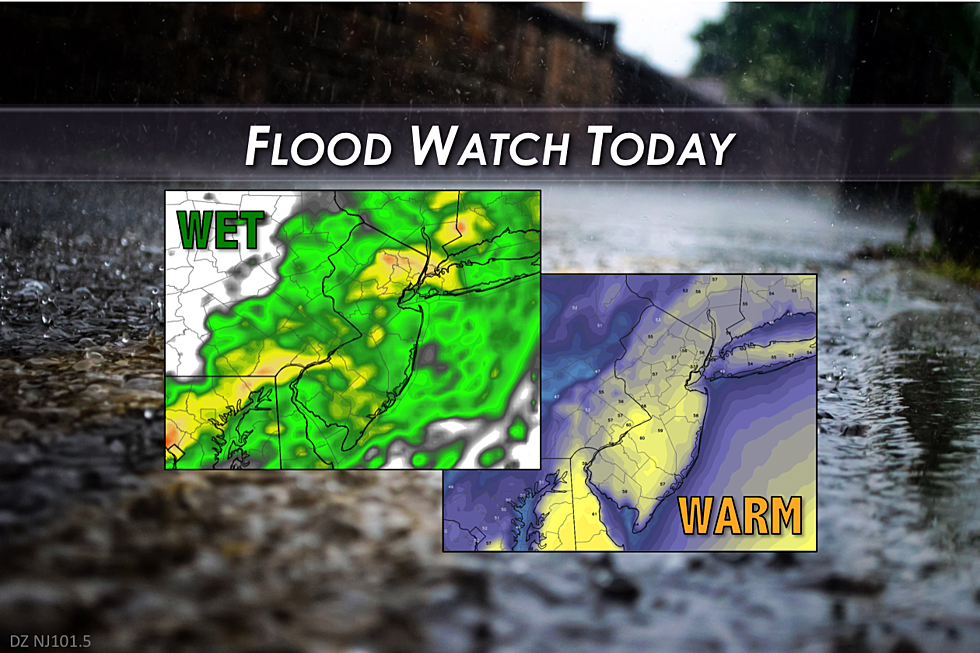
2.) Timing
As you're reading this, the rain is already arriving in the western part of New Jersey. Models show the rain for Wednesday morning will remain scattered - in other words, not everyone in the state will get wet. (This is especially true in far South Jersey and along the Jersey Shore, which may not see raindrops until the afternoon.) As the actual cold front gets closer and closer, the rain is expected to markedly increase in spread and in intensity this afternoon into this evening. Dense fog will be possible as well.
The end of the rain remains a question mark in this forecast, due to some big differences in the model solutions. Ultimately, the speed of the front will directly impact when the rain gets swept out to sea. GFS and Euro push all rain off-shore by about 1 a.m. Thursday morning. The NAM keeps rain around for most of Thursday. I have opted for a middle-ground forecast, keeping the chance for rain over New Jersey through sometime Thursday morning.
3.) Rainfall Totals
This storm system will be tapping into the rich moisture of the Gulf of Mexico, which will help to fuel today's heavy rains. Models have consistently shown generally rainfall totals in the 0.5" to 1.5" range for the Garden State. That's healthy rainfall.
This morning's intermediate (06Z) run of the NAM puts out some very impressive ~3-inch rain totals across a good swath of central and southern New Jersey through Thursday morning. That's some incredibly heavy rain.
4.) The Flooding Situation
Heavy rain by itself can easily spur flooding of streets and streams, as storm drains become inundated and water levels rise. Today, the rapidly melting snow and ice will only exacerbate the potential flooding situation.
The hard-packed snow banks and plow piles still have an incredibly amount of water locked inside. By Thursday morning, almost all snow cover across New Jersey will have melted due to the near-record temperatures and the rain... That melt water has to go somewhere!
The timing of the biggest flooding risk lines up with the timing of the heaviest rain: Wednesday afternoon and evening. The National Weather Service's Flood Watch describes the potential flooding as "minor to moderate". That means large puddles across the road and high fast-flowing streams will be the biggest concerns. The "usual" roadways that flood during almost any torrential rain will probably flood at some point today.
Remember: Never attempt to drive, walk, or swim through flooded areas. Turn Around, Don't Drown!
5.) Severe Weather?
This storm system has a history of some severe, tornadic weather in the southern states on Tuesday. At times, the models have shown a little bit of instability in our atmosphere today. So, yes, thunder and lightning are certainly possible. But the threat for severe wind, hail, and tornadoes is low for New Jersey today.
6.) Beyond the Storm
Our weather will stay fairly active over the coming week, with no fewer than three storms worth watching. The first coastal system looks to clip the Jersey Shore on Friday morning. The precipitation will coincide with the arrival of colder air, so this would be a light snow event. Along the coast, we could see accumulations up to an inch in the early morning hours on Friday.
The weekend looks nice and quiet, as high pressure builds in. Both Saturday and Sunday will feature partly sunny skies with high temperatures in the mid 40s or so. Normal highs for early February are in the lower 40s.
Monday will be another close call, with a storm system passing just off the coast. This should be another miss for the Garden State.
However, in the wake of Monday's storm, another area of low pressure is modeled to form along the Atlantic seaboard. Combined with a low over the Great Lakes, this one could be pretty problematic. Both the GFS and Euro show a wintry solution for New Jersey in the Tuesday to Wednesday time frame. You know the drill - we're still 6 days away, which is still too early to pinpoint exact timing, potential snowfall totals, and other impacts. Just keep Tuesday-Wednesday in the back of your mind for now... As always, we'll be watching and will keep you posted.
Please be safe and be smart today!
More From 94.3 The Point


