
NJ warmup: 50 Tuesday, 50s Wednesday, 60s Thursday, 70s Friday
The overnight batch of rain and snow showers are wrapping up, and the forecast for rest of the week looks fantastically warm. But we have to be patient — the truly warm (i.e. above-normal) temperatures are still a couple of days away.
As expected, there have been some snowflakes mixed into the overnight showers, reported as far south as Burlington County. In colder North Jersey, specifically Sussex County, up to an inch of accumulation has occurred on the grass. Roads are just wet, with no travel or traffic issues reported.

Showers will largely exit by about 9 a.m. Tuesday, although I can't rule out an isolated shower from popping up through Tuesday afternoon. I'm optimistic skies will start to clear by about 4 p.m. Tuesday. Meanwhile, temperatures will be stuck on the cool side for yet another day, with forecast highs around 50. That's about 10 degrees below normal for early-to-mid April.
Skies will continue to clear Tuesday night, allowing for chilly temperatures in the lower to mid 30s.
Wednesday still looks fairly pleasant, although still a bit below seasonal normals. Highs should reach the lower to mid 50s. The morning will be mostly sunny, the afternoon will be partly sunny, and the day looks dry overall. The only weather nuisance will be a stiff southwesterly breeze up to 20 mph.
Our big warmup kicks in Thursday — however, don't expect an incredibly pretty weather day. It will be mostly cloudy and windy, with potential wind gusts over 30 mph. Furthermore, the latest models suggest our "slight shower chance" will be a bit more widespread than I was previously thinking. To be safe, I'd expect a batch of light rain in northern and central NJ, through the Thursday midday hours. I've scaled back temps accordingly, but we should still reach widespread mid 60s by Thursday afternoon.
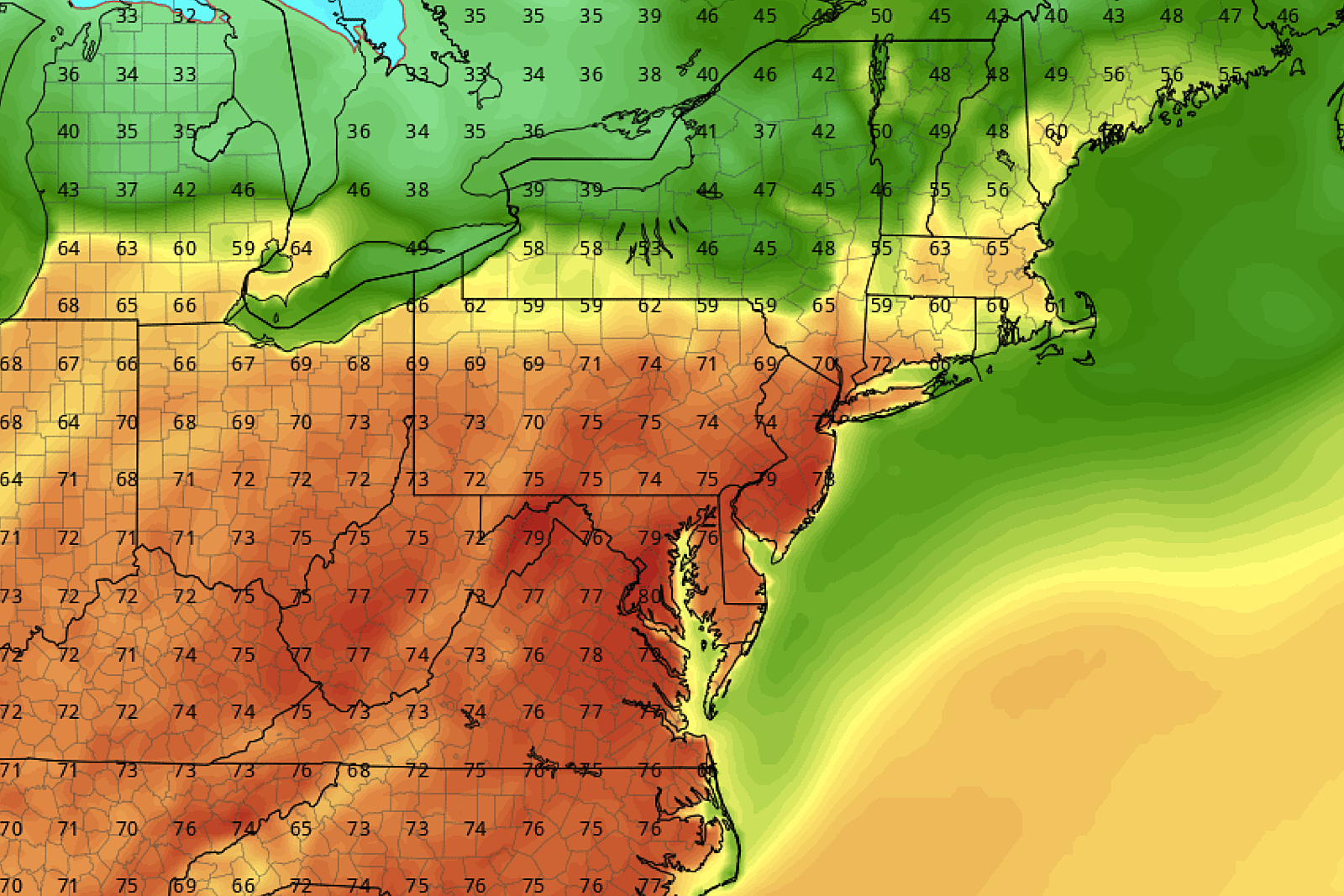
Before we get into the really warm weather at the end of the week, I have to add an important note/disclaimer. The temperatures I note here in my weather blog and in our daily weather forecast represent general conditions over the majority of the Garden State. That fact is especially important here because areas along the Jersey Shore will not experience toasty warm 70s this week. The facts:
1.) The dominant wind direction from Wednesday through Saturday will be southwesterly (from the southwest).
2.) Ocean and bay water temperatures right now are between 43 and 46 degrees — still pretty chilly.
3.) That southwesterly wind will have a significant cooling influence as it blows over the chilly waters.
4.) Therefore, anyone with a large body of water (i.e. a bay) to your southwest — on barrier islands, and along the Delaware Bay — will be warmer (relatively speaking) but not truly warm this week.
Aside from an isolated morning shower Friday morning (the vast majority of NJ will stay dry), we should see abundant sunshine and widespread 70s by Friday afternoon. (Woohoo!) Again, the coast will be significantly cooler — in the 60s if we're lucky. On the flip side, interior southern and central NJ may touch 80 degrees.
Saturday looks about the same. 60s along the coast, 70s inland, maybe an 80 degree reading somewhere. Skies will be a little greyer, in the partly to mostly cloudy range. Still dry, still warmly pleasant.
Sunday will start off warm and breezy, with high temperatures in the lower 70s (at least) for most of the state. However, we'll eventually start to feel the effects of a backdoor cold front draping through the state. We may salvage most of the day, holding off substantial cloud cover and rain chances until Sunday evening. (Although if you asked me yesterday, I'd say Sunday afternoon would turn into a washout.) Forecast details are a little shaky here — just expect some clouds, rain (with potential thunderstorms), and a cooldown heading into early next week.
How much we cooldown is also a really important question. I'm seeing above-normal 60s on Monday. But if we get another shot of cooler air (a very good possibility), temperatures may once again get stuck below-normal for much of next week.
More From 94.3 The Point


