#NoWayJose – minor to moderate coastal and weather impacts for NJ
As Hurricane Jose prepares to make a close pass to the Jersey Shore, we are also watching two additional tropical threats in the Atlantic.
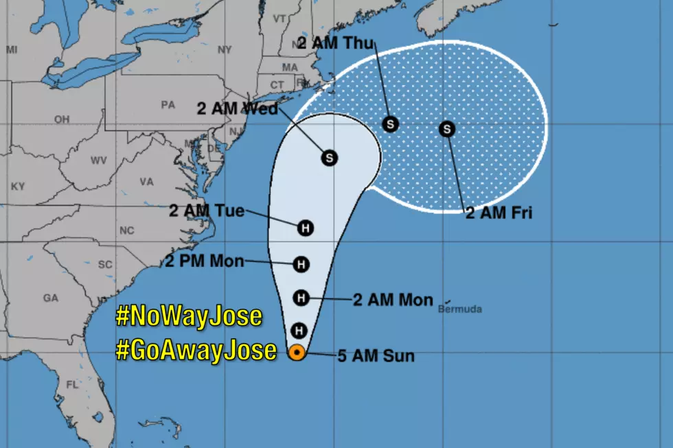
I am pleased to report that the Hurricane Jose forecast has not changed much in the last day or two. The latest thinking is pretty close to the "best-case scenario" I presented on Friday. The official National Hurricane Center storm track has wiggled a bit further east (out-to-sea) since Saturday's epic weather blog post. Not sure if that eastward trend is justified — I would admittedly draw the track a little closer to the Jersey Shore.
As of Sunday morning, Hurricane Jose is centered about 600 miles south-southeast of Cape May. Maximum sustained winds are holding steady at 80 mph. The storm is now moving due north, and will pass neatly between Bermuda and the Carolinas late Sunday through early Monday.
The timing of Jose's visit to New Jersey remains the same: from late Monday night through part of Wednesday.
For the rest of this post, I'm going to focus on 1.) Jose's potential weather and surf impacts on NJ, 2.) one growing concern regarding the track of the storm, and 3.) Lee and Maria, two more tropical storms in the Atlantic basin.
Rough Surf
As Jose churns up the ocean and throws water toward the Jersey Shore, I'm still thinking we'll see waves up to 6 feet breaking along the coast. A High Risk for dangerous rip currents has been posted along all New Jersey beaches. Red flags will be flying through at least the middle of the week.
Coastal Flooding
On Saturday, my initial surge call was 2 to 3 feet. Since the storm's track has shifted off-shore slightly, I'll reduce that to 1 to 2 feet in this forecast. The reduction is good news for coastal communities. But such surge is still enough to cause minor to moderate flooding along tidal waterways at the times of high tide. (Especially given the fact the astronomical tide is a bit higher than usual, due to Tuesday night's New Moon.)
As I've said before, I think the surge level will be akin to a "typical" wintertime nor'easter. The most precarious high tide cycle will be Tuesday afternoon.
Wind
The latest models suggest gusts to 40 mph for inland New Jersey and 50 mph along the coast. Technically, a "severe wind" is 58+ mph. But I think Jose's wind will be high enough to blow around patio furniture, bring down some vulnerable trees and power lines, and cause sporadic power outages. High-profile vehicles (like trucks and vans) may also be difficult to control with such gusts
Rain
The biggest question of all: Will New Jersey see a drop of rain from Jose? The answer appears to be yes, especially if you take stock in the NAM model, which puts a pretty heavy rain band over the Garden State for most of Tuesday.
If a tropical rain band pushes through New Jersey, we'll see rainfall totals between 1 and 3 inches.
If not, rainfall totals will be less than a half-inch.
As you would suspect, the heaviest rain and highest totals will be found along the Jersey Shore.
One Growing Concern
Jose's latest spaghetti plot gets really messy after 72 hours (starting on Wednesday). Several models are suggesting that, instead of rapidly kicking out to sea, the storm will "linger" well off-shore for the second half of the week. An interesting and rare storm track to say the least. However, contrary to some media reports, I doubt Jose will make a second run at the U.S. East coast. For now, just keep in mind that we may very well see elevated winds and surf beyond just Tuesday.
Tropical Storm Lee
Lee is way out in the Atlantic Ocean, on the order of 3,000 miles southeast of New Jersey. Models suggest a northerly track into colder waters over the next five days, and therefore a weakening trend.
Tropical Storm Lee poses no immediate threat to land, and could very well turn into a "fish storm" by driving directly out to sea.
Tropical Storm Maria
On the other hand, the active tropical season continues with Saturday's formation of Tropical Storm Maria. This storm is currently 2,200 miles southeast of New Jersey and 400 miles east of the Caribbean Sea. Rapid intensification is expected, and the National Hurricane Center expects Maria to become a major hurricane as it barrels through the Lesser Antilles, Greater Antilles, Puerto Rico, and Hispaniola. Bad news, as many of these islands are still suffering from the devastation of Hurricane Irma two weeks ago.
Maria could become a threat to the U.S. East Coast in the 7 to 10 day time frame.
Bottom Line
Hurricane Jose will not make a direct hit on New Jersey, but it will be close enough to affect our sky and sea. Tuesday is going to be a yucky day, with some wind-driven rain and high surf. Vulnerable, low-lying areas may experience flooding at the times of high tide — that will probably be Jose's biggest impact on the Garden State.
Unless something changes dramatically, my next weather blog update is scheduled for 7 a.m. Monday morning.
More From 94.3 The Point


