Christmas weekend forecast for NJ: Cold to mild, maybe a sprinkle
The Bottom Line
The big weather story between now and Christmas Day is a transition, from cold to warm. There may be a few raindrops along the way. But I am highly confident the weather will not get in the way of your traveling, last-minute shopping, and/or merriment. No snow, hardly any wind, and no "extreme" weather.
There is another potential soaker of a storm system in the forecast around the middle of next week. Heavy rain is a possibility — but with temperatures in the 60s, wintry weather is unlikely.

Friday
Quiet, but cold.
Friday morning is actually one of the coldest of the season so far, with temperatures mainly in the 20s. Almost the entire state is starting the day frozen.
And high temperatures will only reach about 40 degrees Friday afternoon.
We will see bouts of sunshine, ducking behind clouds often. A light breeze will blow from the north. And our weather will start completely dry, from start to finish. Good news for this big "getaway day".
Friday night will not be quite as cold, as thermometers dip to around 30 degrees. A blanket of increasing clouds will help prevent temps from tanking too much.
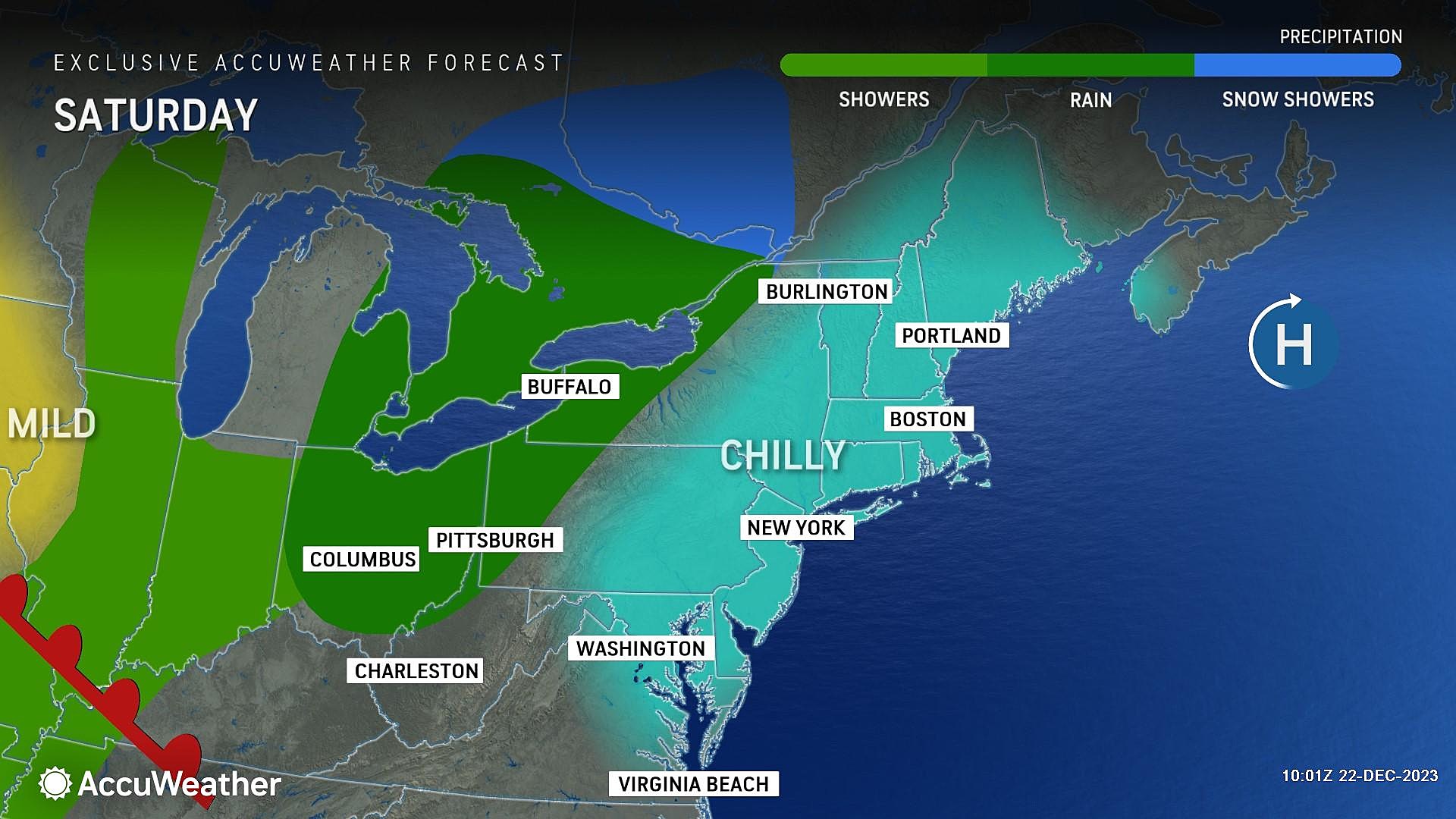
Saturday
Daytime hours look fine. A seasonable, reasonably pleasant December day.
It will be mostly cloudy. But at least temperatures will bump back into the mid 40s.
We will have to watch for a chance of spotty rain showers, starting late Saturday night (around 10 p.m.) It's all light and all liquid — nothing wintry.
Sunday (Christmas Eve)
Christmas Eve begins with brief pockets of damp weather, as those spotty showers may linger as late as Noon-ish. But the afternoon turns dry, as our slow warmup continues.
Sunday will remain mostly cloudy to overcast. High temperatures will end up close to 50 degrees, with a very light southerly breeze.
The forecast for Santa's big ride Sunday night looks great across New Jersey. Temperatures should stay above freezing, with an overnight low around 40 degrees. We'll still have some clouds. And possibly some fog. But it will be a dry and silent night overall.
Monday (Christmas Day)
I was looking at Christmas Day weather statistics from the last decade, and we have really experienced a variety of holiday temperatures. Highs from the 20s to the 70s! This year falls in the middle. Actually, on the mild side, as high temperatures on Monday end up in the lower 50s.
Christmas will be completely dry, with good breaks of sun. No weather problems whatsoever.
Tuesday & Beyond
I just saw a report on the TV news that Tuesday and Wednesday are expected to be the busiest days for air travel this holiday season. And that could be problematic, coinciding with our next "big" weathermaker.
A storm system will come into view through the middle of next week. Once again, it will be a rain maker, with nothing wintry in the forecast at this time. Pockets of steady to heavy rain are possible, centered on Wednesday as the wettest day (for now).
Some models suggest upwards of two inches of rain for part of the state. Having said that, I do not see a huge threat for lightning and/or gusty winds at this time. But that will be something to watch if the atmosphere does become more dynamic.
We will dial in the timing and impacts as it gets a little closer.
Until then, I hope you and yours have a wonderful weekend and the happiest of holidays. The CMDZ weather blog will return early Tuesday morning.
Christmas snow - When it's happened, and the 2023 odds for NJ
Gallery Credit: Mike Brant
Dan Zarrow is Chief Meteorologist for Townsquare Media New Jersey. Follow him on Facebook for the latest forecast and realtime weather updates.
50 of the best holiday lights displays in New Jersey
Gallery Credit: New Jersey 101.5
More From 94.3 The Point
