
Big weather changes for NJ: A warmup, thunderstorms, a cooldown, and frost
The Bottom Line
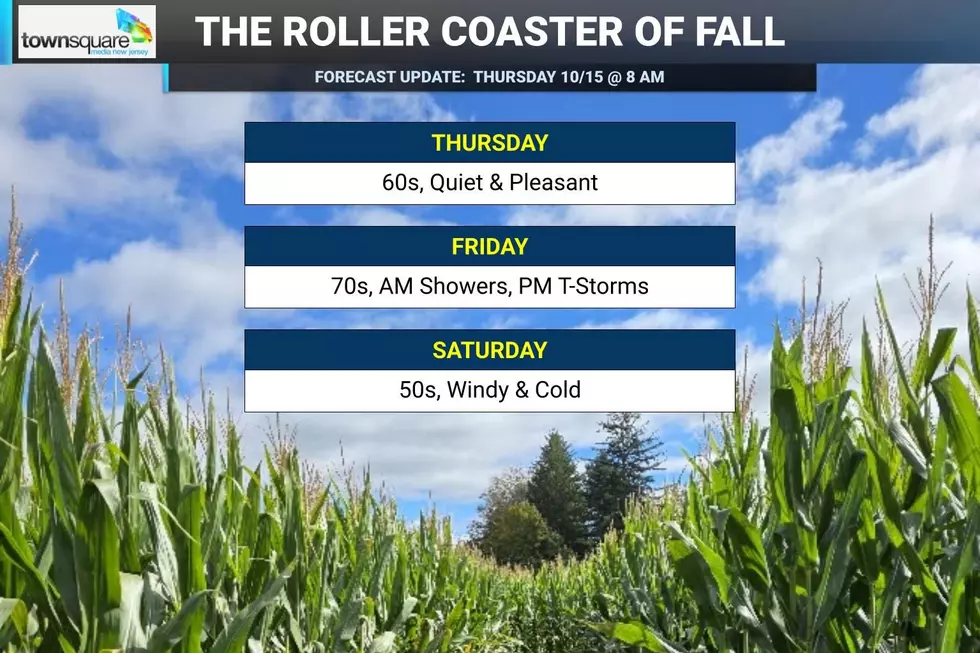
Over the next 48 hours, New Jersey will see more wild weather twists and turns, ending with the arrival of the coldest, driest air of the season so far. Thursday will be about 15 degrees cooler than Wednesday, which felt downright summerlike and broke some temperature records around the state. But it still looks like a pleasant day on balance, with scattered clouds and limited shower chances early and late. Friday turns unsettled, as clouds accompany a surge in warmth and humidity. There will be one push of spotty showers in the morning, and then a bigger line of showers and thunderstorms late-day. Following that cold front passage, the door to much colder air will open this weekend. Saturday will be sunny but windy, with highs only in the 50s — it is going to feel positively November-ish. And by Sunday morning, we are looking at our first widespread 30s of the season, likely leading to the first widespread frost/freeze of the season across inland New Jersey.

Weather Hazards
The Storm Prediction Center has spiked the severe weather potential for Friday’s cold front, putting western New Jersey in a Slight Risk — level 2 of 5 — for damaging wind and/or an isolated tornado. At the very least, some noisy thunderstorms are possible Friday evening as the precursor to our sharp temperature drop.
Wind gusts on Saturday could touch 40 mph, making it feel uncomfortably blustery. And while not “hazardous weather” per se, the season’s first widespread frost/freeze is important for farmers and gardeners, as New Jersey’s growing season likely comes to an end across many inland areas.
Climatological Context
October 15 is the 288th day of 2026. (Happy 1015 Day!)
Normal high temperatures range from 66 to 68 degrees, while normal low temperatures range from 46 to 49 degrees.
October is, on average, New Jersey’s sixth warmest, sixth wettest, and seventh snowiest month of the year.
Thursday
Welcome back to fall, New Jersey.
Wednesday got as warm as 88 degrees (in Cape May Court House). Temperature records were broken and summer vibes were enjoyed. But Thursday will be a very different story.
Cooler, drier air has returned to New Jersey as of Thursday morning. Temperatures have fallen into the 50s across most of New Jersey. Humidity levels have fallen too, making the air crisp and comfortable once again.
We had a few sprinkles early Thursday morning along the southern coast, but they have since exited. The rest of the day should be dry as we are between storm systems at the moment.
Expect partly to mostly sunny skies, an occasional fresh breeze, and afternoon temperatures in the mid 60s. That is roughly 15 to 20 degrees cooler than Wednesday. But that is right in line with typical mid-October weather.
Honestly, there's not much to complain about here. Yet.
Clouds will increase Thursday night. Lows will dip into the upper 50s.
Friday
Friday will not be a “nice” weather day, as our weather turns decidedly unsettled to end the workweek. That doesn't mean washout, it means clouds, humidity, and two rounds of rain.
So baseline forecast: Mostly cloudy, breezy, warmer, and increasingly humid. High temperatures should surge into the mid 70s as New Jersey briefly slides back into a more September-ish air mass.
The day will be bookended by two rain chances:
The first will come Friday morning, as spotty showers lift through the state, associated with a warm front. I don't anticipate anything heavy or dramatic here — just a bit of wet weather between about 4 a.m. and 10 a.m.
Then the atmosphere gets more charged up late Friday afternoon into Friday evening, as a strong cold front barrels toward the state. Scattered showers and thunderstorms are likely.
This is the round that deserves attention.
The Storm Prediction Center has placed western New Jersey in a Slight Risk for strong to severe thunderstorms. Damaging wind gusts would be the primary concern, with an isolated tornado not impossible. Those with Friday evening plans should keep an eye on the sky and remain weather aware.
Lightning and bursts of heavy rain are possible too.
That line of storms also marks the leading edge of a much colder, drier air mass. So once the front clears New Jersey, temperatures will tumble into the weekend.
Saturday
Saturday will feel positively November-ish.
At least the weekend will be sunny and dry for a change!
But do not let that bright sky fool you. Saturday will be blustery: Cold and windy.
High temperatures will only reach about 50 to 55 degrees — a notable change from Wednesday’s 80s, Thursday's 60s, and Friday’s 70s.
Strong north-northwesterly winds will add an extra bite to the air, potentially gusting as high as 40 mph. That is enough to make it feel raw and uncomfortable outside. And those winds could toss around unsecured outdoor objects, cause driving difficulties, bring down small branches, and/or cause sporadic power outages.
This may very well be the start of "permanent" jacket and hoodie weather season.
Sunday & Beyond
By Sunday morning, thanks to the classic combination of cold air, dry conditions, calm winds, and clear skies, temperatures will really bottom out. I think we are apt to see widespread 30s across inland New Jersey. And that would be cold enough for the first widespread frost/freeze of the season. (Note: The surface temperature does not have to hit exactly 32 degrees for frost to form at the surface — I am usually looking for 36 or 37 degrees for that possibility.)
For farmers, gardeners, and anyone still hanging onto sensitive outdoor plants, this could effectively end the growing season.
After that frosty start, the rest of Sunday will be better. Sunshine continues, winds will be considerably lighter, and highs will recover to about the 60-degree mark.
Still chilly. But more comfortable than Saturday.
The extended weekend keeps our weather absolutely silent next week, as dry air keeps a firm grip on New Jersey's atmosphere. Temperatures will likely moderate to seasonable levels, with daily highs in the 60s and lows near 50. Our next substantial chance of rain is likely at least a week away, if not more. (Depending on whether anything fires up in the tropics.)
Get Lost this Fall: Corn Maze 'No-No' Rules
Gallery Credit: Dan Zarrow
Dan Zarrow is Chief Meteorologist for Townsquare Media New Jersey. Follow him on Facebook for the latest forecast and realtime weather updates.
NJ Fall Fun Means Sunflowers, Corn Mazes and Pumpkins
Gallery Credit: Erin Vogt


