
Nasty NJ nor’easter: Moderate flooding, 50+ mph gusts, rain, snow
Our nor'easter has arrived, and we've got some truly nasty weather and rough surf to talk about. This morning's blog post focuses on the highlights and lowlights of Friday's stormy forecast. For more detail and/or meteorological insight, please review my two previous weather blog posts.
Forecast Notes
--This storm is just getting started. We saw about a half-inch of rainfall overnight, with a few reports of localized flooding already.
--Reminder: This is a multi-impact storm: Rain, snow, wind, coastal flooding Forecast confidence is better, but this is still a look out the window storm. My recommendation is to keep your plans flexible as the day goes forward, given the nasty multiple impacts we're going to see all day long.
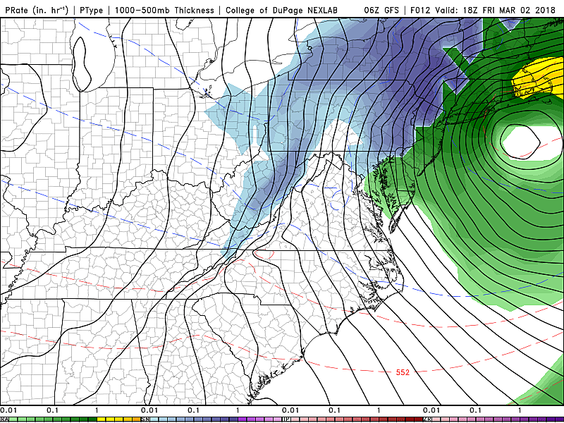
--Storm really ramps up around lunchtime Friday, as wind gusts increase over 40 mph and the transition from rain to mix/snow accelerates.
--Power outages are likely as the combination of fierce winds (as high as 65 mph) and soggy ground bring down trees and power lines.
--Northwest New Jersey will get "thumped" by snow — the higher your elevation, the more you may see on the ground. While there could be some snow and wintry mix through the rest of New Jersey, causing travel troubles, the best guess forecast shows minor accumulations.
--The coastal flooding picture looks ever so slightly better. Latest guidance keeps all Jersey Shore points out of the "major flooding" category. Barely. Surge estimates remain in the 2 to 4 foot range. And "moderate" flooding could still cause some big impacts including road closures and property damage.
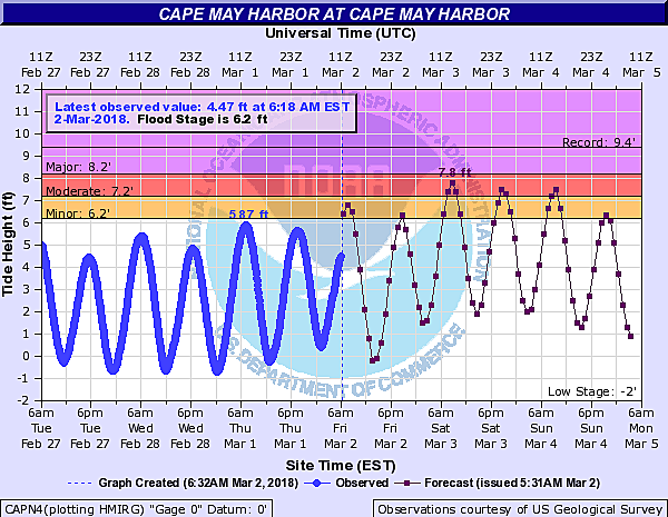
--For the next five high tide cycles,, those along the coast need to keep a close eye on the water level (and hold your breath): Friday morning, Friday evening, Saturday morning (the peak), Saturday evening, and Sunday morning.
Flood Advisories

--Coastal Flood Warning until 2 a.m. Sunday for Cape May and Cumberland counties, calling for minor to moderate flooding at the times of high tide. Spotty major flooding can not be ruled out.
--Coastal Flood Warning until 2 a.m. Sunday for Atlantic, southeastern Burlington, and Ocean counties, calling for minor to moderate flooding at the times of high tide.
--Coastal Flood Warning until 2 a.m. Sunday for Middlesex and Monmouth counties, calling for minor to spotty moderate flooding at the times of high tide.
--Coastal Flood Advisory until 10 p.m. Friday for eastern Essex, Hudson, and eastern Union counties, calling for minor to locally moderate flooding of tidal waterways at the times of high tide.
--Coastal Flood Watch from Saturday morning through Saturday night for eastern Essex, Hudson, and eastern Union counties, which means flooding of tidal waterways is possible. (An upgrade to a warning or advisory may be made later.)
--Flood Watch until 6 a.m. Saturday for Bergen, Burlington, Camden, Essex, Hudson, Hunterdon, Mercer, Middlesex, Monmouth, Morris, Ocean, eastern Passaic, Somerset, Union, and Warren counties, calling for heavy rain and flooding of low-lying and poor drainage areas.
--Several short-fuse Flood Advisories and Flood Warnings have been issued throughout Friday morning, as heavy rain inundates storm drains and causes ponding on roadways.
Wind Advisories

--High Wind Warning until 6 a.m. Saturday for Bergen, Essex, Hudson, eastern Passaic, and Union counties, calling for sustained north winds of 25 to 35 mph with gusts to 60 mph.
--High Wind Warning from 10 a.m. Friday to 6 a.m. Saturday for
Atlantic, Burlington, Camden, Cape May, Cumberland, Gloucester, Mercer, Middlesex, Monmouth, Ocean, and Salem counties, calling for sustained northwest winds of 25 to 35 mph with gusts up to 60 mph.
--Wind Advisory from 10 a.m. Friday to 6 a.m. Saturday for Hunderdon and Somerset counties, calling for northwest sustained winds of 20 to 30 mph with gusts to 55 mph.
Winter Advisories

--Winter Storm Warning until 4 a.m. Saturday for Sussex County, calling for 6 to 12 inches of snow accumulation at elevations above 1000 feet.
--Winter Storm Warning until 6 a.m. Saturday for western Passaic County, calling for 4 to 7 inches of snow with localized amounts up to 11 inches at elevations above 800 feet.
--Winter Weather Advisory from 11 a.m. Friday to 4 a.m. Saturday for Morris and Warren counties, calling for 3 to 6 inches of snow accumulation at elevations above 800 feet.
Yup, a truly nasty day all around! As always, be smart and be safe, New Jersey!
Dan Zarrow is Chief Meteorologist for Townsquare Media New Jersey. Follow him on Facebook or Twitter for the latest forecast and realtime weather updates.
More From 94.3 The Point


