
NJ nor’easter update: Don’t underestimate the wind and surge
Rain arrives first Thursday, and then transitions to mix/snow as temperatures nosedive and the storm strengthens on Friday.
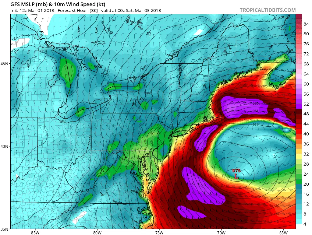
Why So Strong?
In a word, cyclogenesis. It's a pretty typical setup for big storms this time of year — an area of low pressure sliding in from the west "phases" or "merges" with a coastal low. The coastal storm system takes the reins and rapidly intensifies.
Remember the "snow bomb" blizzard of early January? That — although slightly weaker and with a warmer atmosphere.
Those warmer temperatures are a very important part of this forecast, by the way — Thursday's high temperatures are about 60 degrees. The (initially) warm air and warm ground will hopefully (but not definitely) limit significant snow accumulations for most of the state. (Read on...)
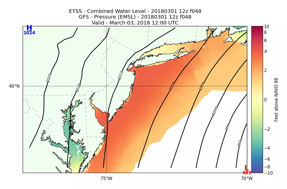
Coastal Flooding
The surge and tide estimates are not getting better, unfortunately. As I mentioned in Thursday morning's weather blog, the next five high tide cycles will be unusually high: Friday morning, Friday afternoon, Saturday morning, Saturday evening, and Sunday morning.
I will mention once again that tide forecasts are highly dependent on the exact wind speed and direction. What I'm about to paint is the picture as it stands Thursday morning.
Saturday morning's high tide looks particularly precarious, as guidance shows a peak in the moderate+ flood category for almost every tide gauge along the Jersey Shore. Here's a roundup of those Saturday morning water level forecasts, according to the Middle Atlantic River Forecast Center:
--Perth Amboy (Arthur Kill)... Forecast crest 8.8 feet... Moderate flooding... Record crest
--Sandy Hook... Forecast crest 8.4 feet... Moderate flooding
--Manasquan (Watson Creek)... Forecast crest 7.8 feet... Major flooding... Notably higher than February 2016 storm (7.00 feet)
--Barnegat Light... Forecast crest 5.3 feet... Moderate flooding
--Atlantic City... Forecast crest 7.9 feet... Moderate flooding (major at 8.0 feet)... Comparable to Blizzard of 2016 surge (7.84 feet)
--Ocean City (Great Egg Harbor Bay)... Forecast crest 7.3 feet... Major flooding... Higher than Irene (6.73 feet)
--Cape May (Harbor)... Forecast crest 8.3 feet... Major flooding... Higher than Irene (7.92 feet), but nowhere near Sandy (8.67 feet) or Blizzard of 2016 (9.36 feet)
--Greenwich (Cohansey River)... Forecast crest 7.8 feet... Minor flooding (moderate at 8.2 feet)
Vulnerable roadways (the "usual spots" and then some) will need to be closed due to flooding. Property damage is possible due to water inundation issues. Remember to never attempt to drive, walk, or swim through flooded areas — it is exceptionally dangerous.
Additionally, expect big waves to batter the beaches, leading to significant erosion.
To be crystal clear, the anticipated surge and subsequent flooding of this nor'easter is nowhere near the severity of Sandy. But if you flooded during Irene in 2011 ("get the hell off the beach"), or perhaps the Blizzard of 2016 ("want me to go down there with a mop"), it would be very wise to take this storm seriously.
Wind
I'm still thinking this storm will spit out some fierce wind gusts, making power outages likely. Strongest winds are forecast to blow in the Friday afternoon and evening time frame.
For inland New Jersey, peak gusts will probably end up around 40 mph. Along the coast, expect 50 mph gusts during the strongest part of the storm, possibly popping over 60 mph at times.
Take time before the storm to batten down the hatches, securing lawn furniture and garbage cans — they can easily become projectiles in such conditions.
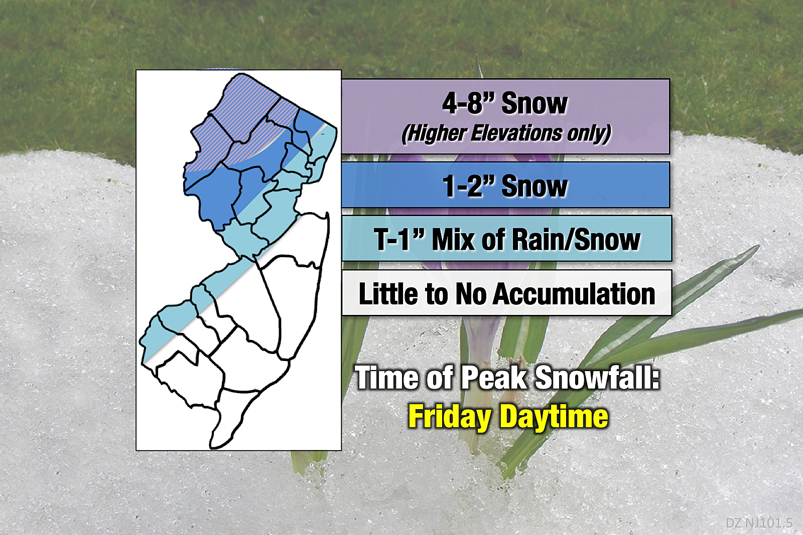
Snow
This remains the big wildcard in this forecast. Will temperatures crash fast enough on Friday to sustain a brief "thumping" of heavy snow? And, if so, how much will be able to accumulate on the ground?
I'm holding steady on my Thursday morning forecast, calling for travel-inhibiting snow in the higher elevations of NW NJ, and nuisance slush/ice/snow/rain for the rest of the state (especially away from the coast). But keep an eye on the ever-changing conditions on Friday, as this is probably going to be a "look out the window" storm in terms of the precipitation type.
Be prepared for driving conditions to deteriorate significantly Friday afternoon and evening, especially the further north and west you are. As we've learned several times this winter, it won't take much ice, slush, and/or snow to make for a very slippery situation.
It's going to be quite a storm, folks. As always, be smart, be safe.
Dan Zarrow is Chief Meteorologist for Townsquare Media New Jersey. Follow him on Facebook or Twitter for the latest forecast and realtime weather updates.
More From 94.3 The Point


