Winter Storm Warning: 60s Wednesday, 6+ inches of snow Thursday
A Winter Storm Warning has been issued for 18 of New Jersey's 21 counties for Thursday morning, as snowfall rates could approach 1 to 2 inches per hour.
Warm Wednesday
The northern half of New Jersey is quite a bit cooler than forecast Wednesday morning, with chilly 30s and 40s on the thermometer. Meanwhile, we're already seeing balmy 60s across the southern half of NJ!
I remain optimistic that the entire state will get a taste of warmer air by Wednesday midday, topping out in the upper 50s to mid 60s. While we've had some fog and showers early Wednesday morning, breaks of sunshine are expected by Wednesday afternoon.
Please enjoy the relatively quiet, mild, springlike weather while it lasts. A strong cold front will begin affecting New Jersey by late afternoon Wednesday. That will cause thermometers to drop sharply through Wednesday night, setting us up for wintry weather by Thursday morning.
Winter Storm Timeline
The first bands of precipitation will pass over the Delaware River between about 1 a.m. and 4 a.m. Thursday morning.
Heavier snow and rain bands should arrive between 4 a.m. and 10 a.m. The "main event" will be all snow across North Jersey. Central Jersey and inland South Jersey will see a quick change from rain to sleet to snow by daybreak Thursday. The southern coast will see mostly rain, but a brief period of heavy snow will be possible after sunrise.
Heavy snow and rain will taper to showers by about 10 a.m.
Showers should exit the Garden State completely Wednesday afternoon.
Winter Storm Warning
The National Weather Service has issued a Winter Storm Warning for 18 of New Jersey's 21 counties. Here is the breakdown:
--Winter Storm Warning from Midnight to 6 p.m. Thursday for Bergen, Essex, Hudson, Passaic, and Union counties.
--Winter Storm Warning from Midnight to 4 p.m. Thursday for Hunterdon, Mercer, Middlesex, western Monmouth, Morris, Somerset, Sussex, and Warren counties.
--Winter Storm Warning from 4 a.m. to 4 p.m. Thursday for Burlington, Camden, Gloucester, eastern Monmouth, Ocean, and Salem.
--Winter Weather Advisory from 8 a.m. to 2 p.m. Thursday for Atlantic, Cape May, and Cumberland counties.
Bottom line? Near-zero visibility and snowy, icy roads will make travel treacherous (if not impossible) for most of Thursday morning. Trains and planes will have major delays and cancellations too. In addition, the heavy, wet characteristic of the snow could contribute to downed trees and power lines, contributing to scattered power outages. Shoveling will also be quite a chore.
Snowfall Totals
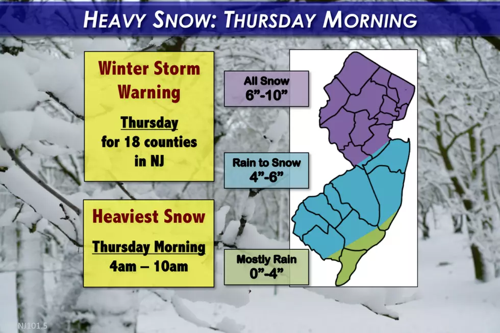
See the map at the top of this post for a graphical depiction of our forecast:
--6 to 10 inches of snow accumulation are expected along and north of the Route 1 corridor
--4 to 6 inches are forecast from the Turnpike corridor in SW NJ to Monmouth and Ocean counties
--Up to 4 inches of snow will be possible along the south coast (Atlantic, Cape May, and Cumberland counties)
Things to watch for:
--I may ultimately decrease the snow forecast around Sussex and Warren counties, as NW NJ will be on the northern fringe of the heaviest snow bands.
--I'm on the fence regarding Monmouth County. I almost swung the higher 6-10" contour further south to encompass that area.
--The forecast for the south coast is highly uncertain. It's going to be a "boom or bust" situation around Cape May County, with either 0" or 4" on the ground by the end of the storm. It all depends on exactly how temperatures and precipitation bands set up.
Forecast Challenges
--It's all about the storm track. Forecast confidence continues to improve with each model run. And there seems to be good consensus supporting the large area of 6 to 10 inch snowfall I have delineated across northern and central New Jersey. But we have to be cognizant that there's a margin of error to any forecast. Any little "wiggle" in the storm's motion could significantly impact the overall outcome.
--It's all about temperatures too. My forecast includes some bold (necessary) assumptions about the rain-to-snow transition. If the north to south cooldown trends slower or faster than I have laid out here, the snowfall forecast will be a bust.
--Could it snow more? Sure, I've seen localized forecast snow totals as high as 15 inches. However, I'm banking on the limited time period and geography of all heavy snow - that's why I've decreased our top snow forecast from a foot to 10 inches (admittedly not a big change).
--Could it snow less? Sure, but I think the chance for a total bust is low, as every major forecast model now clearly shows a snowy solution for the Garden State.
--The European model is a scary outlier. The Euro paints the heaviest snowfall about 50 to 100 miles further south than other models. Even parts of South Jersey could see double-digit snow totals. However, this solution seems to ignore the above-freezing temperatures that seem almost a sure bet at the storm's onset. Additionally, the Euro ensemble trends strongly toward our going forecast.
Beyond the Storm
We'll see clearing skies by Thursday night. Of course, the combo of clear skies, cold air, and snow cover will lead to a frigid night. Lows will fall to the teens by Friday morning, with single digits possible in North Jersey.
Friday afternoon will be cold too, with most thermometers peaking only in the lower 30s. The forecast for the weekend is a bit warmer, with scattered showers (especially on Sunday).
We're officially in full Winter Weather Alert mode until the final flakes fall. Stay tuned for the latest info from our weather, news, and traffic teams. Next weather blog update expected by 5 p.m. Wednesday.
Dan Zarrow is Chief Meteorologist for Townsquare Media New Jersey. Follow him on Facebook or Twitter for the latest forecast and realtime weather updates.
More from 94.3 The Point:
More From 94.3 The Point


