
Winter Storm Watch: How close will powerful snowstorm get to NJ?
Thursday's snow forecast still contains many question marks and potential scenarios, with less than 36 hours to go before first flakes.
This post is an update to my previous forecasts for Thursday's winter storm. For a full picture, you may want to read or skim Monday afternoon's and Tuesday morning's weather blog entries too.
Upping the Forecast
Let me start by insisting that the big snow ("Buried") and little snow ("On the edge/Middle ground") scenarios are both very much still in play for Thursday's winter storm. The no snow option appears to be off the table.
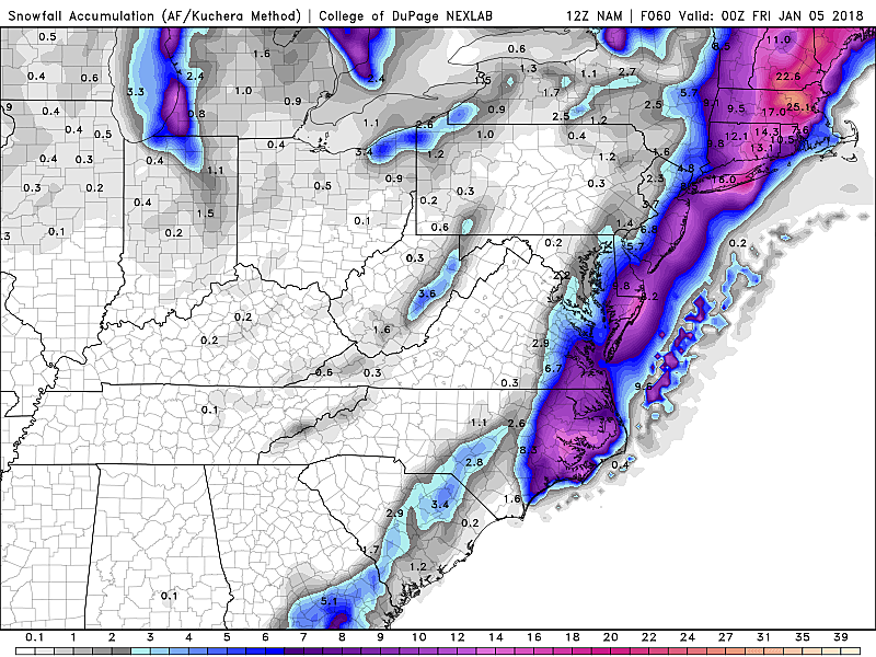
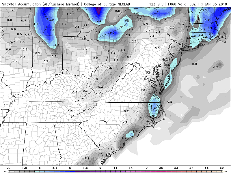
The reality is that each individual model has changed only slightly since this morning. The NAM is still quite aggressive, painting double-digit snowfall totals along the Jersey Shore on Thursday. It's enough to raise an eyebrow, even though all the other primary forecast models remain tepid about potential snow. (The SREF — the NAM ensemble — is more reasonable, and is my favored model at the moment.)
In the end, I decided to generally increase my forecast for one simple reason: We're now within 36 hours of first flakes, and at this point we can't ignore the real possibility of higher, more significant snow totals.
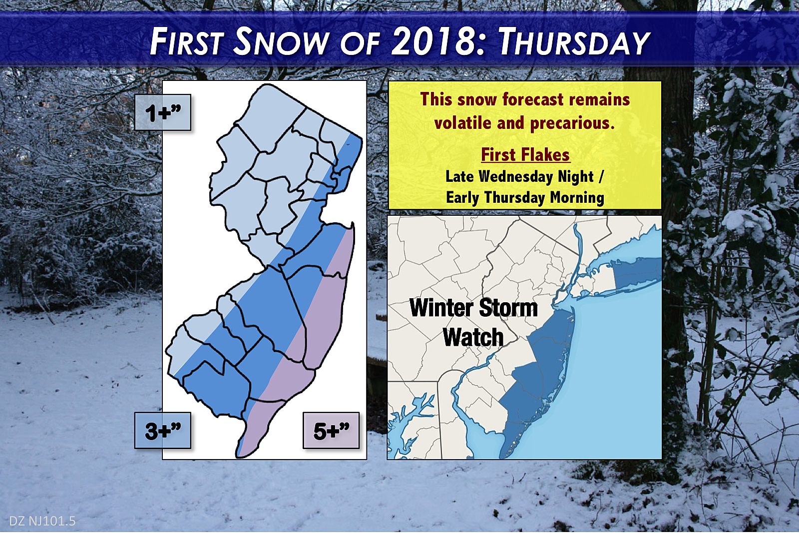
Our latest forecast shows everyone in New Jersey is prone to see at least an inch or two of snow. No matter what, the biggest accumulations will occur along the Jersey Shore. I'm currently saying top totals will end up in the 4 to 6 inch neighborhood, but there's still a chance that number will go even higher (or possibly lower again) as storm time approaches.
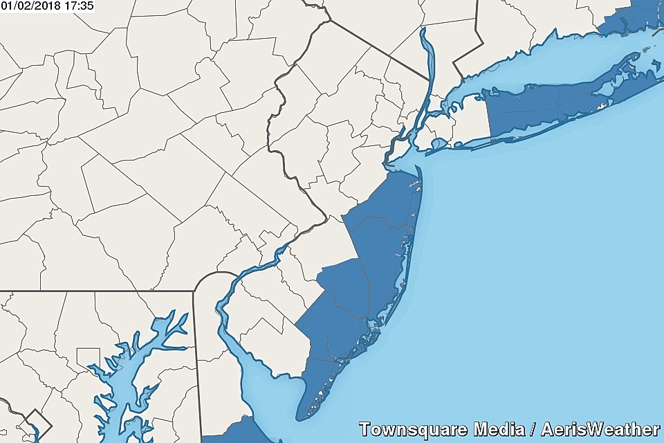
Winter Storm Watch
Because of the timing, and the chance for significant travel impacts, the National Weather Service has issued a Winter Storm Watch for New Jersey's coastal counties: Monmouth, Ocean, southeastern Burlington, Atlantic, and Cape May. The watch specifically calls for wintry conditions between 9 p.m. Wednesday and 7 p.m. Thursday.
I think the NWS got the timing and placement of this watch perfectly right. If the threat remains for a half-foot of snow or more (not a guarantee), look for an upgrade to a Winter Storm Warning around Wednesday afternoon.
The Case for "Big Snow"
As I mentioned, I've seen models spit out upwards of 12 inches of snow for coastal New Jersey. Here are the top three reasons why this very snowy solution could win out:
--Due to the frigid temperatures, there won't be any mixing or icing — this is an all snow event.
--The last few storms have been subject to over-performance due to increased snow ratios. If the forecast is even colder and drier than expected, this one could follow suit.
--This coastal storm is going to become a monster, deepening significant just after after it passes the Jersey Shore. It's not good to underestimate storms that are "bombing out" like this.
The Case for "Little Snow"
I'm still maintaining a conservative, middle-of-the-road forecast. Here are my top three concerns:
--This arctic air mass is huge and powerful in its own right. That big dome of cold air needs to be perfectly placed, to allow this coastal storm to skirt parallel to the Atlantic seaboard. If the cold air mass wins, the center of the storm ends up further out to sea, and we end up with less snow.
--Not only is it cold, it's incredibly dry. Usually, a big storm system like this can overcome even the driest air. But the low dew points may prevent (or at least stall) heavy snow from setting up over the Garden State.
--It is a quick-hitting storm. First flakes early Thursday, peaking Thursday morning, done Thursday afternoon. Not an extended opportunity for snow to pile up and pile up and pile up.
The Wind
While many New Jerseyans are laser-focused on Thursday's snow potential, let's not forget about or ignore the wind and cold that will follow. This reinvigorated arctic chill will rival anything we've seen so far during this post-Christmas arctic blast.
Wind gusts of 40-50 mph.
High temperatures only in the teens.
Wind chills below zero *all day* Friday and Saturday.
That's ridiculous cold. Painful cold. Dangerous cold.
The Coast
I had been concerned about the potential for big waves and coastal flooding along the Jersey Shore — but I'm feeling better now. Initial winds will be out of the north, turning northwesterly (meaning from the northwest) as the storm departs. Not a lot of wind-driven water pushing toward the coast, so not a lot of surge. (If the storm's center were closer to the beaches, we'd have a threat for easterly winds, and this would be an entirely different conversation.) It's still something worth watching, but I think residents of coastal communities can exhale for now.
Action Steps
There's obviously no need to panic over this impending snowstorm — it doesn't spell impending doom. And there's no immediate need to stock up on those "alcoholic french toast" supplies just yet. (Well, only if you want to.)
I've gotten a few questions about air travel on Thursday. If you're planning to fly Thursday morning, you may want to look at alternate options, especially if your airline is letting you change your travel plans for free. This is especially true for flights out of EWR, ACY, and JFK. We might fare a little better at PHL and TTN. Even though flights should resume quickly after the snow ends Thursday afternoon, there may be a big backlog of travelers the airlines need to accommodate.
In general, at this point, you should think about your personal routine and plan for Thursday, in case the "worst-case scenario" snowfall forecast comes true. (i.e. 12+ inches) Will you even attempt to go to work? If you're a decision-maker, how high will the snowfall forecast need to go before you cancel or delay your school or business opening? Do you need to put the plow and/or sander back on the truck? Are your shovel, snow brush, and/or salt ready and handy?
Where We Go From Here
Did you know there are people out there who I think I take joy in sitting on the fence over a forecast? People who believe I play sneaky weather forecast mind games on purpose? People who can't believe that I'm wracking my brain 25 hours a day to try to find some resolution to an incredibly complicated and nuanced forecast?
A few miles may very well make the difference between snow boom and snow bust. Typical of a coastal storm like this, the difference is within a forecast's margin of error — making it incredibly difficult to make an accurate forecast and to communicate it coherently and precisely.
I'm not keeping you on the edge of your seat on purpose — unfortunately, our forecast models have been pretty poor this year, up until the last 24 hours. Let's see where guidance trends on Wednesday, and then I will adjust my forecast accordingly.
Next weather blog update will be posted by 7 a.m. Wednesday. Stay warm!
Dan Zarrow is Chief Meteorologist for Townsquare Media New Jersey. Follow him on Facebook or Twitter for the latest forecast and realtime weather updates.
More From 94.3 The Point


