A phenomenal first weekend of summer for NJ: Warm, sunny, dry
The Bottom Line
Wow. This weekend's forecast really checks all the boxes. It will be warm, but not too hot. It will be humid, but not steamy. Bright skies will accompany dry weather. A delightful sea breeze will keep the coast cooler, keeping beaches busy. And rain stays away until early next week.
Grab the sunglasses and sunscreen, stay hydrated and cool, and enjoy.

Friday
We are battling some fog to begin the day, a symptom of Thursday's rain and the continuing humidity in the air. Visibility has been particularly low around the far northern (Sussex) and southern (Millville and Wildwood) corners of the state.
By 8 or 9 a.m., fog will be done. And the rest of your Friday will be fantastic.
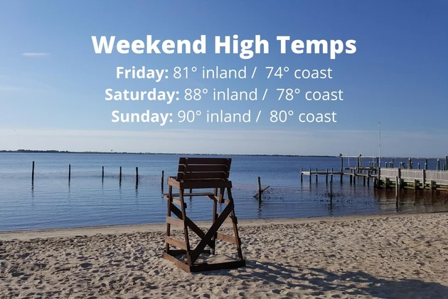
Under mostly to partly sunny skies, temperatures will warm into the lower 80s across most of the state. That is right on the normal high for late June.
Of course, the sea breeze "machine" is a big deal in the forecast this time of year. Sunshine warms up the land mass faster than the ocean. As long as the background wind isn't too strong, that heating difference causes a local circulation to set up. And that's how we get the refreshing easterly breeze that keeps beaches cooler and comfortable than inland areas.
Coastal areas — generally along and east of the Garden State Parkway — will probably see lower to mid 70s Friday afternoon, as that sea breeze kicks in.
If you're going to make it a beach day, be sure to lather up on sunscreen. And keep in mind, we have a Moderate risk of rip currents posted along the Jersey Shore for one more day.
Although I had previously included a shower chance in Friday's forecast, I've ultimate decided to keep it dry. A couple models try to pop a sprinkle Friday evening, but I'm not buying it. Enjoy the dry, seasonably warm weather.
Friday night looks good too. Clear and quiet, with just a hint of stickiness in the air. Low temperatures will bottom out in the mid 60s. Also pretty typical for this point in the season.
Saturday
Temperatures are going to cook. Humidity levels will be moderate — not tropical or dangerous, but certainly enough to make you sweat. But as long as you like it warm and summery, you'll love the weekend forecast.
Saturday will push into the upper 80s across interior New Jersey, with 70s at the Jersey Shore. It will be sunny and dry, with a light southwest breeze. To quote Forrest Gump: "That's all I have to say about that."
Sunday
Sunday looks like the hotter day of the weekend, with inland highs averaging 90 degrees. But because dew points will be reasonable, we do not have to ring alarm bells for potentially dangerous heat — the "heat index" (the "feels like" temperature) will be close to the actual air temperature.
The only change for Sunday is the introduction of clouds in the afternoon. Still a nice summer day.
Some guidance pushes in a shower late Sunday night. (Probably after Midnight, so that would technically be Monday.)
Monday
Monday, we get wet. It's the only rain chance left in the month of June for New Jersey, as a cold front slowly sinks from northwest to southeast.
And "slowly" is the key word there. It looks like this boundary is going to take all day to make it's pass.
The end result: About 6 hours of rain for any given location, during the daytime hours on Monday. Areas north and west would be wettest in the morning. Areas south and east would be wettest in the afternoon.
While I'm not worried about severe wind or flooding, there could be some rumbles of thunder Monday. (Remember: By definition, every thunderstorm contains lightning. Therefore, every thunderstorm is potentially dangerous.)
High temperatures on Monday will depend largely on the timing of the rain. I've settled on a range between the lower 70s (North Jersey) and 80-ish (South Jersey).
The Extended Forecast
Behind the front will come a slight cooldown. Even more prominent will be the "drydown" — a significant (although temporary) drop in humidity.
So next week, we flip right back to awesome weather. Clouds to sun and near 80 on Tuesday. Mostly sunny and lower 80s on Wednesday. Mostly sunny and mid-upper 80s on Thursday.
Our next opportunity for rain could come at the start of the 4th of July Weekend, late next week. But it's still too early and models are still too scatterbrained to make a confident call on that.
Have a wonderful weekend!
Dan Zarrow is Chief Meteorologist for Townsquare Media New Jersey. Follow him on Facebook or Twitter for the latest forecast and realtime weather updates.
An enlightening tour of Washington, NJ ... all six of them!
NJ school holidays with the biggest buzz
More From 94.3 The Point


