
Coastal storm brushes by NJ: Chilly, windy, and damp this weekend
As we've been discussing all week, a strong off-shore storm system — call it a nor'easter if you want — will drive New Jersey's weather this weekend. It's not really making a "direct" impact here, but it will be close enough to bring some noticeable weather changes. Unfortunately, none of those changes are all that pleasant.
I'm writing this special Saturday edition of the weather blog to highlight the variety of weather impacts we're going to see and feel over the weekend. My concerns are growing about the wind and coastal flooding threats in particular. So it's time to ramp up the urgency and language in this forecast a bit, to make sure everyone is informed and prepared as we begin the weekend.
Cold and Blustery
We are already feeling the effects of our visiting storm complex. After a nice day Friday, chilly air returned to the Garden State Friday night.
This cooldown will not be as painful or dramatic as our previous arctic blast. But it's definitely going to feel cold and blustery and raw on Saturday.
Saturday morning's low temperatures are mainly in the 30s. But let's not forget about the brisk northerly wind, gusting to 30-40 mph (especially along the eastern edge of the state). That has been enough to push the wind chill ("feels like" or "apparent" temperature) into the teens and 20s. It's another morning to make use of your winter coat as you open the front door.
Saturday afternoon will only top out in the upper 30s to around 40 degrees. A continuing bitter breeze will keep the wind chill in the mid 20s to lower 30s all day. Nowhere near truly dangerous cold, but it will be wintry and uncomfortable. It's unseasonable too — these temperatures are about 15 to 20 degrees below seasonal normals for mid-November.
At least we'll enjoy some good sunshine and dry weather Saturday.
Wind
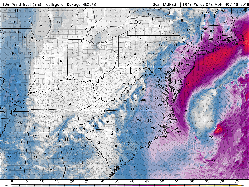
It may get even windier through Sunday, as the aforementioned coastal storm makes its closest pass to the Jersey Shore. Some gust estimates reach as high as 50 mph — that is only for the immediate coast. For most of the state, I think we're facing gusts of 40 mph, peaking late Sunday into Monday. That's enough to make walking and driving difficult, blow around garbage cans, bring down branches, and also cause sporadic power outages. The wind will also add an extra bite to Sunday's chilly air (temperatures in the 40s).
A Wind Advisory has been issued for coastal Atlantic and coastal Cape May counties only, through 6 p.m. Sunday. I wouldn't be surprise if that advisory is extended (in time) and/or expanded (in area) at some point over the weekend.
Coastal Flooding
Powerful storm system between the U.S. East Coast and Bermuda? Check.
Strong northeasterly winds for an extended period of time? Check.
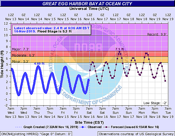
It's a formula for rough surf and storm surge, and a recipe for coastal flooding along the Jersey Shore. The more I look at the tide data and forecasts, the more worried I become. I think we're facing 1 to 2 feet of surge, sparking a few rounds of minor to moderate level tidal flooding over the next few days.
The highest high tide cycle looks to be Sunday morning (around 10 a.m. on the oceanfront, up to several hours later on back bays), with widespread moderate flooding likely.
Second highest would be Monday morning (around 11 a.m. on the Atlantic Ocean), again with moderate category flooding likely.
Water levels during the Saturday morning, Sunday night, and Monday night high tide cycles will likely run higher than normal, possibly popping above flood stage for a brief time.
Moderate flooding is where things get serious — there could be entire streets inundated and closed, property damage, etc. (For reference, New Jersey's last "widespread moderate" tidal flooding event happened at the start of the Columbus Day Weekend in early October.)
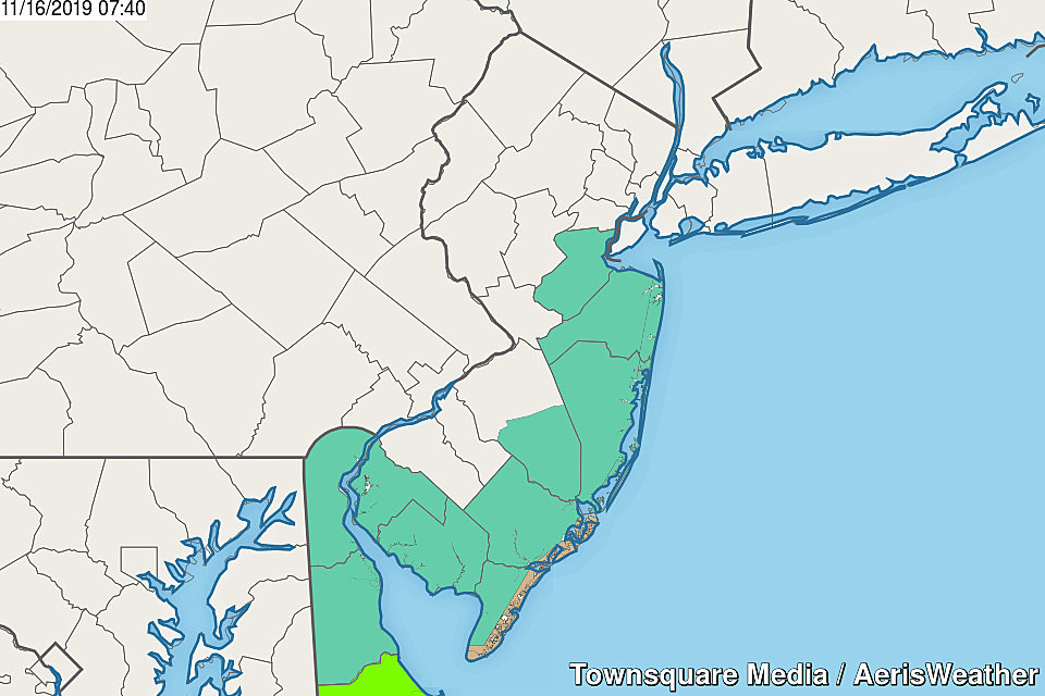
A Coastal Flood Watch is posted from 8 a.m. Sunday to 5 p.m. Monday for the entire New Jersey coastline. That includes Middlesex, Monmouth, Ocean, Atlantic, Cape May, Cumberland, and Salem counties. In addition to the moderate coastal flooding threat, the watch references ocean wave heights growing to 10 to 15 feet!
Mint green = Coastal Flood Watch, Tan = Wind Advisory.
Rain
We've discussed a lot of chaotic weather and surf conditions so far, but haven't touched on rain yet. In Friday's weather blog update, I talked about the high uncertainty in our weekend rain forecast, due to some serious model inconsistencies. I landed on a forecast of Coastal showers likely, steadier rain possible..
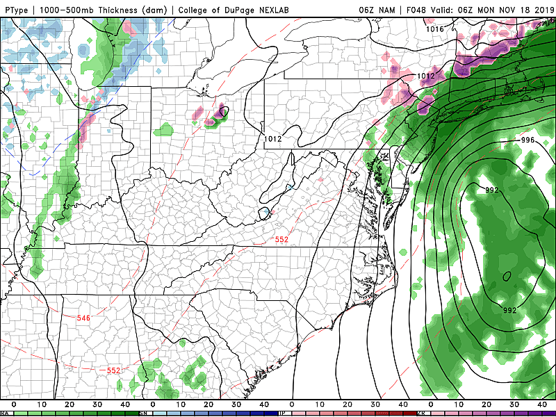
The latest model guidance shows that not much has changed. The NAM model still shows a closer storm track and therefore more impactful, steadier rain from late Sunday through Monday. (Although notably, the center of the storm is trending east in the latest NAM.) The GFS and Euro models, meanwhile, still show only a glancing blow with showers generally limited to the eastern half of New Jersey.
I'm still leaning in the mainly dry direction, so no changes to the going forecast. But we still have to leave the door open for the wetter solution. (Frustrating, I know.)
Anything Wintry?
'Tis the season for snowflakes and icy patches. And so with every passing storm system, we have to ask whether winter weather is possible.
Bottom line, it's possible, but I'm not overly concerned. As usual, it will come down to a matter of timing and geography.
1.) If the storm produces precipitation early Sunday morning (pre-dawn) or late Sunday night, temperatures at both the surface and aloft would support some wintry mix.
2.) If a band of precipitation reaches (colder, far inland) northwestern New Jersey, we could also see some wintry mix.
Having said that, I do not see any threat of extended snowfall or substantial accumulation in New Jersey. A brief dusting, or some slippery spots? Sure, especially in NW NJ in scenario #2. If temperatures were 10 degrees colder? Hoo boy.
Looking Long-Range
Once this storm system finally leaves us alone — Tuesday morning, at the latest — quieter weather will take over. We could see a welcome little warmup through Wednesday and Thursday. But in general, we're still facing a cooler-than-usual second half of November. Just like the first half of the month, of course.
Dan Zarrow is Chief Meteorologist for Townsquare Media New Jersey. Follow him on Facebook or Twitter for the latest forecast and realtime weather updates.
More From 94.3 The Point


