
How Ian will impact NJ this weekend: Rain, wind, surge timeline
The Bottom Line
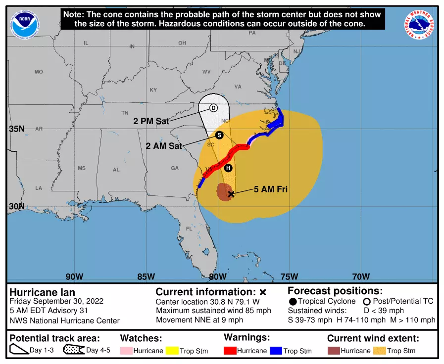
Ian is a hurricane again. As of Friday morning, the storm is centered 600 miles south-southwest of New Jersey, gearing up for its fourth and final landfall along the South Carolina coast Friday afternoon.
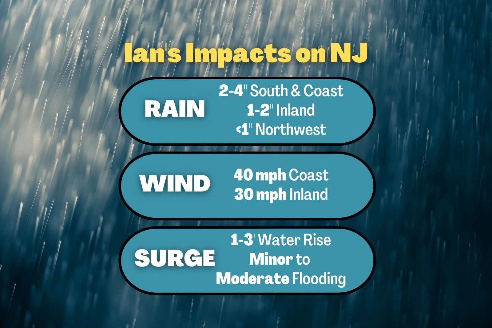
Ian is battling a block of high pressure to our north and some very dry air. That's why initial showers will be very slow to arrive. However, once rain begins in New Jersey, we are going to get soaked. The worst, wettest weather is still expected through the first half of Saturday. (Although I still don't think the day will be a total washout.) The strongest winds will probably hold off until Sunday. And that strong northeasterly wind will likely produce some coastal flooding too.
By early next week, stubborn post-tropical Ian is going to get stuck over the mid-Atlantic. (In fact, some models show it trying to redevelop as it ejects into the Atlantic Ocean.) So we have to keep rain chances in the forecast for Monday and Tuesday, at least. If you're looking for our next sunny, dry, mild weather day, you'll be waiting almost a week.
Friday Daytime
Most of the state should stay during the daytime hours Friday. Showers will eventually bubble up into South Jersey Friday afternoon, perhaps spreading as far north as Interstate 195 through sunset. Initial raindrops will be scattered and light.
Otherwise, it will be a mostly cloudy and calm day. Cool in the morning, near 50 degrees. And relatively cool in the afternoon, topping out in the mid 60s.
Friday Night
Rain will continue spreading north. The northern third of the state (north of Interstate 78) may stay dry until well after Midnight. Eventually — by daybreak Saturday — everyone in the state will be getting wet.
Meanwhile, it will get breezy overnight. Top wind gusts may exceed 20 mph.
Saturday Morning-Midday
The wettest part of the weekend. Let's call it 4 a.m. to 2 p.m. — that's when your outdoor activities will be in trouble.
Pockets of heavy rain will sweep through New Jersey, probably fueling an occasionally gusty wind (over 30 mph). Pretty nasty. Heavy rain may cause ponding and areas of flooding to develop. Despite the downpours, the threat for severe weather (wind, hail, tornadoes) will be low. (Although, not zero.)
Saturday Afternoon-Evening
Potentially better and drier, as the rain lets up. (Especially Saturday evening.) Note: I am not calling it "dry" and "good" — there may be some showers and drizzle and fog around. (In fact, recent model runs suggest more lingering rain than they previously had.). However, I am hopeful that New Jersey will transition to "mainly dry" weather. At the very least, we will lose the threat of heavy downpours and flash flooding.
Sunday
Sunday is tricky, because there will still be some rain showers in the neighborhood. (One piece of energy will be pushing off-shore, with another to our southwest.) So again, it won't be a completely dry day for New Jersey. Just drier.
In addition, as the center of Ian's remnant low approaches, the ambient wind will also noticeably kick up one more notch. Gusts to 30 mph (inland) or 40 mph (coast) are possible.
It is also going to be cloudy and miserably cool on Sunday. Temperatures probably won't climb higher than the 50s statewide.
Also, because of the increased winds, the threat for coastal flooding also kicks in Sunday. Storm surge of 1 to 3 feet is expected. That is enough to cause widespread minor to localized moderate flooding along tidal waterways at high tide. That water rise will likely happen for several high tide cycles in a row, really until the storm exits and our wind shifts (midweek).
Monday
Another generally lull in rain, although we are not done with Ian yet. While we may see a few showers (especially to the south), you may also catch a few peeks of sun (especially to the north). Still breezy, if not windy. And still cooler than normal, with highs only around 60 degrees. (Keep in mind, the long-term average for early October is closer to 70.)
Tuesday
The forecast gets really hazy and muddled by Tuesday, as it's unclear exactly how Ian's remnant low will maneuver. There is a chance of redevelopment, which would drive another round of (potentailly heavy) rain through New Jersey in the Tuesday-Wednesday time frame. On the other hand, there is a decent shot the storm complex just shoots eastward out to sea instead. Sorry to be so wishy-washy — we will see how model consensus evolves over the next couple of days.
The Extended Forecast
Once Ian exits, the wind will shift and the sun will come out. And bother of those factors will send high temperatures shooting back up to 70 degrees. Wednesday-Thursday could turn into a couple of very nice days.
A late-week cold front will likely drive in another quick batch of wet weather, followed by another knockback in temperatures. We're still looking generally cooler-than-normal for the first half of October.
Dan Zarrow is Chief Meteorologist for Townsquare Media New Jersey. Follow him on Facebook or Twitter for the latest forecast and realtime weather updates.
Fright Fest 2022
Gallery Credit: Shawn Michaels
You're Not From Jersey Unless...
Gallery Credit: Jeff Deminski
More From 94.3 The Point


