Icy mix to heavy rain to snow: Messy weather for NJ Sunday-Monday
UPDATE as of 4:05 p.m. Friday...
No sooner had I published this blog update than the National Weather Service popped out a Winter Storm Watch for northwestern New Jersey. It covers the "cold corner" of the state - western Bergen, Hunterdon, Morris, western Passaic, Somerset, Sussex, and Warren counties from Sunday morning through Monday evening. They're calling for 4 to 8 inches of snow, and up to a tenth of an inch of ice. What a dramatic difference from just 36 hours ago, when the forecast was wet and definitely not wintry.
A Watch serves as a formal heads-up to potentially hazardous weather. It may be upgraded to a Warning, which means such dangerous weather is imminent. Or transitioned to a less-severe Advisory, which cautions against minor travel impacts.
ORIGINAL POST from 3:05 p.m. Friday...
Hello and Happy Black Friday, New Jersey.
As I discussed on Tuesday, Wednesday, and Thursday, a powerful storm system is barreling across the continental United States, causing holiday travel disruptions galore. As of this writing, that storm is centered way out west, over the Rockies and Four Corners.
It's time to start getting serious about the very real probability of some messy weather and travel conditions affecting New Jersey for both Sunday and Monday. Forecast models are trending colder and therefore snowier. Yes, I think it's fair to call this New Jersey's first winter storm of the season. And Mother Nature is really going to throw the "kitchen sink" at us in terms of precipitation type and impacts.
To be clear, the rest of Friday and all day Saturday look chilly, but quiet. No travel worries at all.
Sunday and Monday, however, will be a different story. Bad news for the end of the extended Thanksgiving weekend.
As I've done previously, I'm going to break this storm system's timeline into three parts. As confidence continues to grow and we get closer to first flakes/drops, I can offer some more specifics into potential timing and totals.
Phase 1: Midnight to Noon Sunday
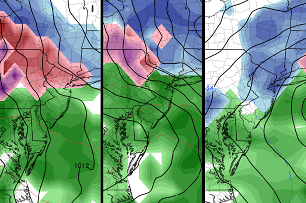
As our storm system arrives in the pre-dawn hours of Sunday, surface temperatures will be just below freezing in North Jersey and just above freezing for the rest of the state.
For areas away from the (warmer) coastal counties, we're looking at a quick hit of wintry mix Sunday morning. That is some semi-nebulous combination of snow, sleet, rain, and freezing rain. And again, we're talking about northern, central, and western NJ.
Roads could get icy in a hurry. And, if temperatures remain cold enough for long enough, a quick half-inch to an inch of snow accumulation is possible. (Especially on colder surfaces like grass, cars, roofs, etc.)
Phase 2: Noon Sunday to 8 a.m. Monday
For most of New Jersey, temperatures will warm sufficiently to force a transition to rain, rain, rain. However, as our storm system taps into some Gulf of Mexico moisture, that rain is likely to become heavy at times Sunday afternoon. So even during that wet period, travel by road or air won't be fun at all.
It looks like drier air will allow for a lull in precipitation from Sunday evening through early Monday morning. Temperatures should generally stay above-freezing overnight, so I'm not worried about a flash freeze or black ice.
Note: there is an important exception in this phase of the storm - far northern New Jersey, from I-80 to the NY state line. Those higher-elevation areas will certainly be colder, and therefore more prone to wintry weather and icy conditions. (It is wholly possible that far North Jersey does not fully transition to rain for the duration of this system.)
Phase 3: 8 a.m. Monday to 2 a.m. Tuesday
Over the last 24 hours, just about all of our forecast model guidance has come around to the idea of colder temperatures and more snow (versus rain) for the grand finale on Monday. I can't say I'm surprised - I've previously mentioned the possibility of such a cold air intrusion on the backside of this system.
So there is resounding evidence toward a forecast of accumulating snow during the daytime hours on Monday. My only hesitation right now in drawing a snow map and promoting the idea of impactful snowfall? Cold air is dry air. And I'm concerned our models are overdoing the last round of precipitation, and therefore overestimating snow totals. (There's still a lot of variety from model-to-model and from run-to-run, so uncertainty remains high.)
If I had to wager a guess, I'd probably draw a 3-6" snow line from Interstate 78 north, 1-3" from Interstate 195 to I-78, and a coating to 1" south of I-195 and away from the coast. Again, these are very early estimates, and subject to change wildly over the next day or so.
The timing of this last piece of the storm is also troubling. We may actually fare OK during Monday morning's commute to work/school. Then falling temperatures allow for light-moderate snow from Monday midday through evening. I hate to say it, but this timeline is reminiscent of the #Snovember #Brinegate storm from November 2018 - everyone got to work fine, but deteriorating conditions made for a truly hellish evening commute. A situation like that could be our worst-case scenario this time around.
What Now?
Our forecast for phases 1 and 2 hasn't wavered much, so I think we're locked in to a semi-icy Sunday morning and a very wet Sunday afternoon. If you have to travel home from the Thanksgiving holiday, doing so on Saturday or waiting until Sunday night would be your best bet.
However, phase 3 is still a low-confidence question mark. And most likely, the messiest part of this whole winter weather event. While I've given my best guess forecast as it stands right now, a little shift in track or temperatures could drastically change what falls from the sky on Monday. Everyone needs to continue monitoring this potential winter storm carefully - especially for those who live, work, or travel through the northern third of New Jersey.
In general, we can start to piece together a detailed winter storm forecast about 48 hours in advance. For Monday, that window is rapidly approaching. NWS will probably issue advisories soon (at least for phase 1).
I'm still committed to updating the forecast (at least) once-daily through the rest of the holiday weekend, so you can make plans accordingly. My next weather blog update will be posted on Saturday (time to be determined). If the forecast for Monday still looks wintry, I'll probably put together a more detailed timeline and/or a snow map at that time.
Ready or not, here it comes! #LetItSnow #IHateSnow
Dan Zarrow is Chief Meteorologist for Townsquare Media New Jersey. Follow him on Facebook or Twitter for the latest forecast and realtime weather updates.
More From 94.3 The Point


