
Insufferable heat and humidity return to NJ, some thunderstorms too
UPDATE as of 8:55 a.m. Thursday...
The latest Drought Monitor was released this morning by the National Drought Mitigation Center. Despite recent rains, the area designating "Moderate Drought" in New Jersey has almost doubled, from 12% last week to just over 23% this week.
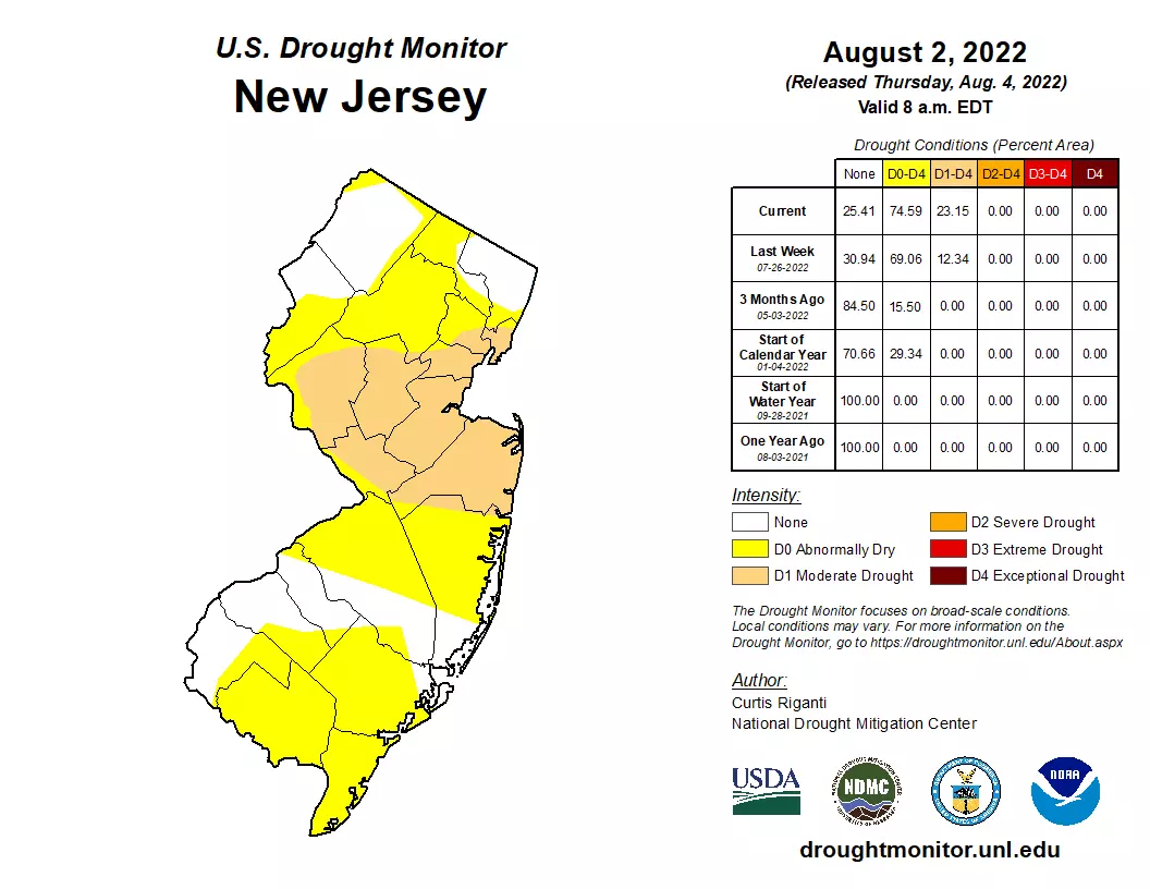
Pieces of Hudson, Essex, Union, Somerset, Hunterdon, Mercer, Middlesex, Monmouth, and Ocean counties are now in the "D2" category.
Meanwhile, about three-quarters of the state is now classified as abnormally dry. The only exceptions are along stretches in northern and southern New Jersey.
Parts of the drought-stricken area need about 6 inches of rain to make up the deficit incurred over the last 60 days. And with each dry day, the situation continues to get more serious.
ORIGINAL POST from 6:37 a.m. Thursday...
The Bottom Line
Heat and humidity are surging into New Jersey once again. And they'll be here, with very little relief, for about the next week. More days than not in the forecast feature highs in the 90s. The heat index will flirt with triple digits.
Meanwhile, we also have to talk about a return to semi-unsettled weather. Showers and thunderstorms are possible on each of the next four days — especially late-day Friday and late-day Saturday. It won't be the widespread drenching we need, deep moisture in the atmosphere will almost certainly produce pockets of heavy rain.
Our next big cold front arrives next Tuesday into Wednesday. A full five days away. Until then, we broil, bake, and fry.
Thursday
Hot. Period, full stop. We return to the heat and humidity "danger zone" on Thursday.
The morning actually isn't half bad, with temperatures around 70 degrees — similar to every other morning this week so far.
I'll also mention that, for the first time since April, the sun is rising at 6 a.m. for part of New Jersey. Days are slowly getting shorter — only 7 weeks until we fall into autumn.
High temperatures on Thursday will shoot into the mid 90s. The hottest part of the state will be the NJ Turnpike corridor, which could touch the upper 90s. On the flip side, the Jersey Shore will benefit from a partial sea breeze, providing some relief.
A Heat Advisory has been issued for most of interior New Jersey. It starts at 11 a.m. Thursday, right around when temperatures will start to push into the 90s. And the advisory will continue until 8 p.m. Friday.
Just to give you a few numbers for comparison purposes. The hottest day so far this summer occurred July 24th: 102 at Newark, 98 at Trenton, and 99 and Atlantic City. And the record highs for this day in history: 100 at Newark, 98 at Trenton, and 98 at Atlantic City.
Dew points are also on the rise, meaning humidity is on the rise. The heat index (or "feels like" or "apparent" temperature) will probably pop above 100 degrees for a few hours across interior New Jersey Thursday afternoon.
Remember, that's our benchmark for going beyond normal, run-of-the-mill, everyday summer conditions. The heat and humidity will be downright dangerous if you don't take care of yourself. Dress for the weather, stay extra hydrated, and take frequent breaks (in air conditioning, if possible).
The daytime hours will be mostly sunny and dry.
There is a chance for a popup thunderstorm Thursday evening, as temperatures cool just before sunset. It would be isolated — nothing widespread.
Otherwise, Thursday night will just be steamy. Low temperatures will only fall into the mid 70s across most of the Garden State. Urban areas may struggle to drop much below 80 degrees — that is uncomfortably warm for late night and early morning.
Friday
Believe it or not, the air gets even thicker.
Friday will still be hot and even more humid than Thursday. Look for highs in the lower 90s. Even though the temperature will be lower than Thursday, dew points will be higher. So the heat index may still flirt with the triple-digit mark.
We had been watching a chance for soaking rain on Friday, which has since fizzled. Now, I would put a spotty shower chance in the morning. And then a few thunderstorms are likely to popup from mid-afternoon through late evening.
We are going to tap into some deep moisture on Friday. Given how juicy the atmosphere will be, I have no doubt that any storm that blossoms will produce some very heavy rain. Wind gusts and lightning would be concerns too.
Is it a washout? No. Will everyone see a storm? No. (In fact, the GFS model has really backed off the idea of appreciable rain on Friday.)
Do we need the rain? Heck yes. Is flooding a concern? Also yes.
Saturday
Same story, different day.
Under mostly cloudy skies, high temperatures will "only" reach the upper 80s on Saturday. Technically, that breaks the latest heat wave (90+) — but such temperatures are still above normal for early August, and still very warm. Humidity will still be moderate to high too.
Saturday also presents another opportunity for scattered showers, thunderstorms, and downpours. The timing is exactly the same as Friday — from mid-afternoon through early evening.
Sunday
Another hazy, lazy summer day.
Although an isolated shower is possible, I have dried out my Sunday forecast.
Partly sunny. Lower to mid 90s.
The Extended Forecast
Monday and Tuesday will come very close to the danger zone again, with highs primarily in the mid 90s. Very little chance of rain there.
Our next substantial storm system — a glorious cold front — is set to arrive Tuesday night into Wednesday. It should drive in some rain, lasting through at least the first half of Wednesday. And we should see an influx of cooler, drier air too.
So by next Thursday, things will turn more seasonable and more comfortable. Only a week away — hang in there!
Dan Zarrow is Chief Meteorologist for Townsquare Media New Jersey. Follow him on Facebook or Twitter for the latest forecast and realtime weather updates.
LOOK: The states with the most UFO sightings
Gallery Credit: Nicole Caldwell & Matt Albasi
LOOK: 31 breathtaking images from NASA's public library
Gallery Credit: Deborah Brosseau
More From 94.3 The Point


