Monday morning NJ winter storm update: 6-12″ snow south, nothing north
UPDATE... This article is outdated...
For the latest winter storm forecast information, please refer to my newest weather blog post.
UPDATE as of 10:50 a.m. Monday...
Entering the midday hours, the block of moderate to heavy snow has shifted farther north. The most widespread (read: most northern) extend of snow is expected through early afternoon.
UPDATE as of 9:25 a.m. Monday...
As expected, the line between "snow" and "no snow" has been very distinct so far. Cutting right through the middle of Burlington and Ocean counties. Unfortunately, that demarkation ended up about 20 miles south than I anticipated. Hence, no snowflakes north of I-195 yet.
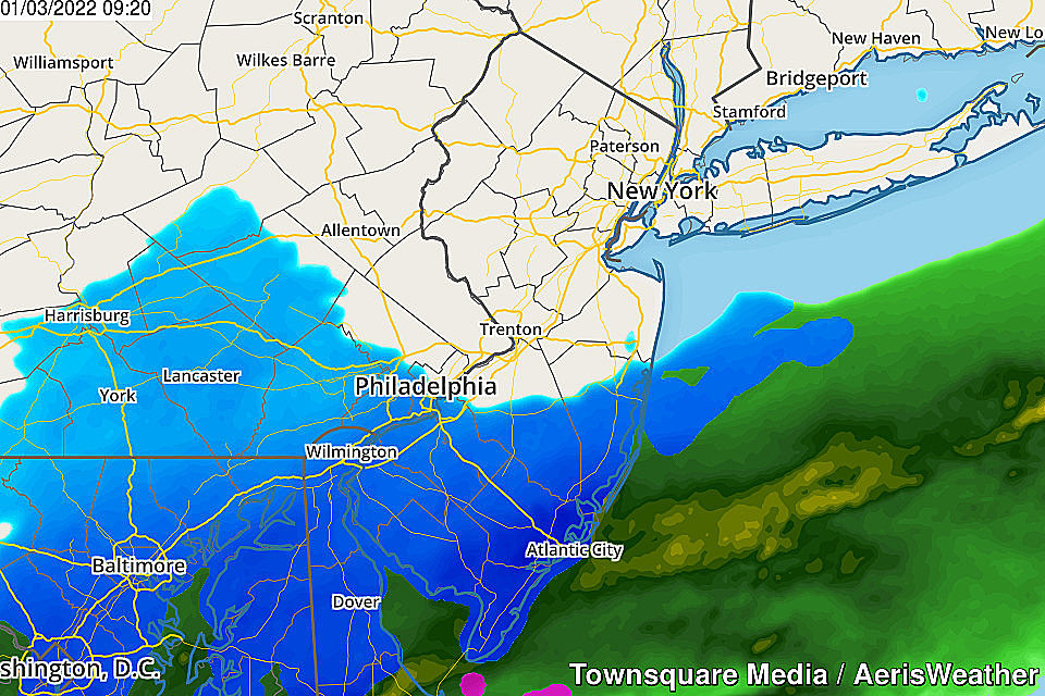
We are still in the peak of Monday's winter storm, as moderate to heavy snow continues to fall over southeastern New Jersey. Several inches are already on the ground around Atlantic, Cape May, and Cumberland counties.
I'm still thinking the snow shield will expand farther into central NJ around midday, before things wind down through the afternoon hours. But whether the snow sticks or accumulates north of the current snow zone? We'll see.
All previous winter weather and coastal flooding warnings and advisories remain in effect.
UPDATE as of 7:45 a.m. Monday...
The epic battle is on. A strong coastal storm system is waging war against dry air and warm ground. And which one wins depends upon where in the state you live.
Watching the latest radar trends, I am very worried about the northern extent of my final snow forecast. There will be a sharp cutoff somewhere over New Jersey between "snow" and "no snow". Likely in my "1 to 3 inch contour". At this point, I even have to wonder if areas north of I-195 ultimately see little to no snow accumulation at all.
Meanwhile, heavy snow has begun over Cumberland, Cape May, and Atlantic counties, clearing the "bullseye" or "sweet spot" for this storm. The ground is already whitening up, and travel headaches have already been reported.
There's a long way to go before our first winter storm of the season winds down, Monday afternoon. Stay warm and be careful out there.
ORIGINAL POST from 6:27 a.m. Monday...
The Bottom Line
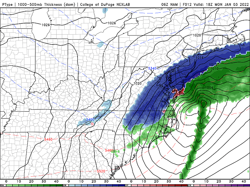
Our first winter storm of the season and of 2022 is here. And the latest guidance and initial observations confirm one big fact: It is going to become a significant snowmaker, for part of New Jersey at least. (That's a very important statement: The "low" outlier scenarios, held in the back of our mind, are really off the table now.)
Early rain and icy mix will change to all snow early Monday morning as temperatures drop. The heaviest and most widespread snow is expected from mid to late morning. Things will start winding down Monday afternoon, ending completely by around dinnertime.
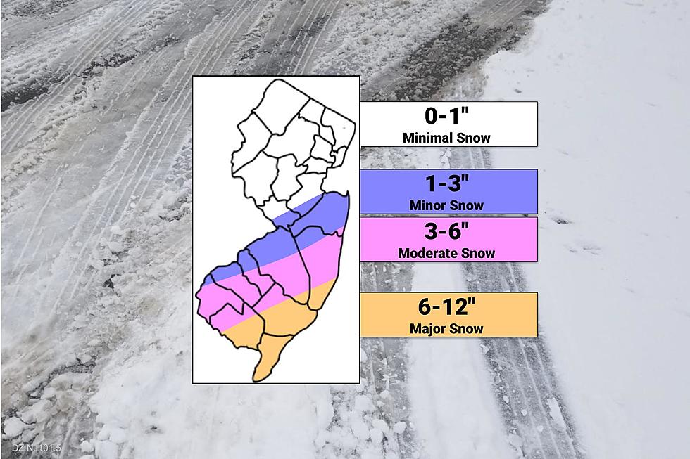
Accumulations will range from nothing in North Jersey to 6-12" along the southern coast. The middle is the tricky part, of course. It's all about where the heavy rain bands set up, and how dry air plays into this stormy, wintry weather scenario.
Travel conditions will be treacherous. Schools and business have already started to close. The wind will blow. The cold air will bite. Coastal flooding will be an issue too.
Let's do it. Winter is here.
Advisories
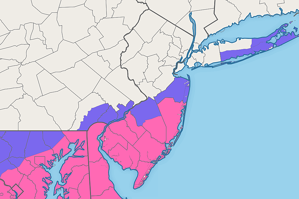
—Winter Storm Warning... Now in effect until 4 p.m. for Ocean, SE Burlington, Atlantic, Cape May, Cumberland, Salem, Gloucester, and Camden counties.
—Winter Weather Advisory... Less-urgent, less-severe extending north into NW Burlington and Monmouth counties, also through 4 p.m.
—Coastal Flood Warning... Posted for Atlantic and Cape May counties, calling for widespread moderate flooding of tidal waterways during the morning-midday high tide cycle.
—Coastal Flood Advisory... Issued for the rest of the Jersey Shore, Raritan Bay, Delaware Bay, and Delaware River with minor category flooding expected.
Timeline
—Start... Initial precipitation bands creep northward early this morning, first as rain and icy mix, then flipping to all snow by around 9 a.m. at the latest.
—Peak... The brunt of the storm, with the heaviest snow and trickiest road conditions will be in the mid to late morning hours, between about 8 a.m. to Noon. The most widespread (farthest north) snowfall will probably come a little later, from around 10 a.m. to 2 p.m.
—End... Snow will start to wind down by mid afternoon, with final snowflakes falling by around 6 p.m.
Accumulations
—Major Snow... 6 to 12 inches of snow accumulation are forecast south of a line between Salem and Toms River. (Note: Some forecast models are still showing raw snowfall output as high as 20 inches. There's no way that's going to happen.)
—Moderate Snow... 3 to 6 inches seems like a good estimate along a swath between Salem and NE Ocean/SE Monmouth counties.
—Minor Snow... North of a line between Camden and Long Branch, it's going to be difficult for more than 3 inches to stick and accumulate.
—Minimal Snow... Although I believe we could see a coating of snow on the ground as far north as the Interstate 78 corridor, this will not be North Jersey's storm.
Other Impacts
—Wind Gusts... Over 30 mph at times. Combined with snow and ice, that could be enough to cause sporadic power outages and knocked-over garbage cans.
—Wind Chill... As temperatures fall from the mid 30s (early morning) to upper 20s (late afternoon), the wind chill (or "feels like" or "apparent" temperature) will be stuck in the teens all day. That air is going to bite — bundle up!
—Coastal Flooding... Up to 2 feet of water inundation is possible during the Monday morning-midday high tide cycle. That may necessitate road closures and could even cause some property damage.
Additional Considerations
—Confidence... Moderate. Dry air and warm ground are still the potential killers of this snow forecast. And also how far north the heavy, accumulating snow will spread. (I'm least confident about the location/presence of the 1-3" contour on my map above.) However, as I mentioned above, forecast models settled on a pretty solid "not a bust" consensus over the last few runs. Just be very careful about what snow forecasts you trust — raw model output is absolutely overdoing the snowfall potential of this storm.
—Boom or Bust... The snowfall forecast ranges I've listed above very specifically cover both the "best/lowest case" and "worst/highest case" scenarios for each segment of the state. I suspect final totals will either end up at the top or bottom of those ranges. Boom or bust.
—Melt... You'd be wise to get shoveling as soon as possible Monday, as temperatures Monday night are going to be very cold. Especially over areas with fresh snowpack. Beware of continuing icy spots overnight. We should see some snow melt on Tuesday, thanks to a combination of bright sunshine and (slightly) above freezing temperatures.
Beyond the Storm
—Tuesday... Sunny, dry, and calm. High temperatures will remain below normal for early January, in the mid to upper 30s.
—Wednesday... Becoming mostly cloudy. An influx of warmer, wetter air will push high temperatures into the mid to upper 40s (especially near the coast). Our next storm system will be a weak one, but could drive in some spotty rain showers.
—Thursday... Quiet and chilly. Clouds and sun, with highs near 40.
—Friday... Models are hinting at some light snow clipping southern NJ early on. Then partly sunny and 30s.
Our news, weather, traffic, digital, and programming teams are hard at work to provide you the latest updates before, during, and after the storm. Stay smart, be safe, and keep warm out there.
Dan Zarrow is Chief Meteorologist for Townsquare Media New Jersey. Follow him on Facebook or Twitter for the latest forecast and realtime weather updates.
The Blizzard of '96 Revisited: Snow totals for every NJ county
Gallery Credit: Joe Votruba
First flakes: When does snow season start in NJ?
Gallery Credit: Dan Zarrow
Counting down New Jersey's top 15 weather stories of 2021
Gallery Credit: Dan Zarrow
More From 94.3 The Point


