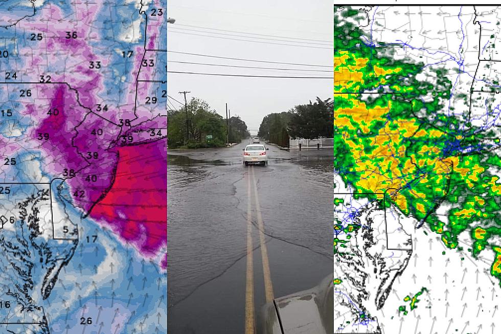
Nasty weather returns to NJ Friday: Wind, coastal flooding, rain
UPDATE as of 2 p.m. Friday...
So far, it's been a breezy, cloudy, cool day. Aside from far southern New Jersey, rain has been minimal. That is about to change as we charge toward this storm system's "prime time" here in the Garden State, still in the 4 p.m. to 2 a.m. window.
Here are some fresh thoughts on this multi-impact forecast:
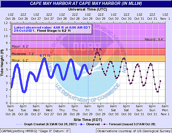
—The Atlantic Ocean is at high tide as of this writing, 2 p.m. Back bays and tributaries will crest 2 to 3 hours later, just in time for the Friday evening commute. The Delaware River won't reach its peak until about 10 p.m.
—The risk of coastal flooding is still pretty notable, and has already occurred in some spots. Check out my colleague Dan Alexander's recent article for more:
—Tidal guidance for the Delaware River, in particular, is showing areas exceeding "major" flood stage. That's serious stuff. Low-lying areas in Salem, Gloucester, Camden, Burlington, and Mercer counties could have some real water trouble tonight. (Again, the river crests around 10pm.)
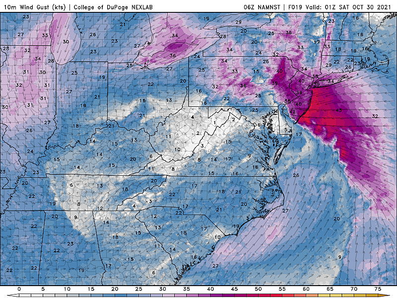
—Top wind gust in NJ so far today: 43 mph. I'm still thinking they go as high as 50 or 60 mph as the storm really kicks in this evening.
—Timing forecast for the stormy weather is holding steady. Prime time kicks in for South Jersey by around 5-6pm, reaching North Jersey by 8-9pm.
Be smart, stay safe, the worst is coming up...
The Bottom Line
For the second time this week, we're staring down a nasty, multi-impact storm system. While rain will be heavy at times, this one is going to be an effective windmaker. That will cause power outages, low visibility in rain, and serious coastal flooding. Peak impacts from the storm will be between about 4 p.m. Friday and 2 a.m. Saturday.

We head into the final weekend of October with a continuing chance of rain on Saturday. But Sunday's trick-or-treat forecast looks much drier, brighter, and less scary.
A Prominent Anniversary
Nine years ago today — October 29, 2012 — a powerful post-tropical cyclone made landfall here in New Jersey. Sandy. The most significant weather event of most New Jerseyans' lifetime.
And what do you know, Mother Nature is celebrating with wind and coastal flooding and heavy rain. I think it's totally fair to mention the coincidence of this being an especially active weather date through history.
But let's be absolutely crystal clear: The impacts from this storm will be nowhere near as severe as Superstorm Sandy's.
Timeline
—Friday Morning... Fairly quiet. Breezy, with a few showers and sprinkles bubbling up from the south. Cool, with temperatures starting around 50 degrees.
—Friday Early Afternoon... Showers become more numerous and more widespread. Mostly cloudy and still cool, with highs barely hitting 60.
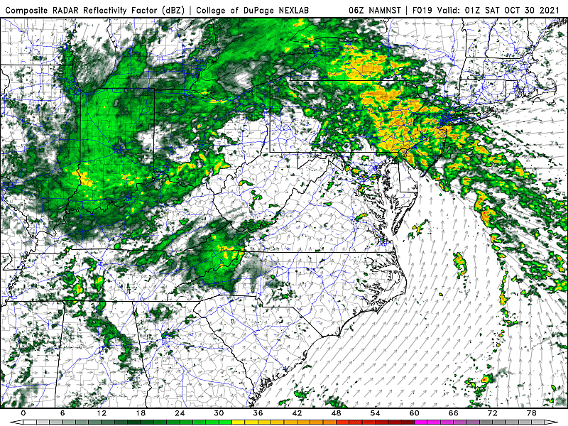
—Friday Late Afternoon... Bands of heavy rain start to arrive, generally driving from south to north. Some embedded thunderstorms are possible.
—Friday Evening... Strong easterly wind kicks in, lasting several hours in any given location. Peak gusts will be found along the coast.
—Friday Late Night... Conditions will calm and our weather will dry out after about Midnight. Scattered rain will remain possible through the day on Saturday too.
Biggest Impact: Wind
Don't be surprised by the easterly winds that will howl during the peak of the storm. Gusts could top 50 or even 60 mph along the Jersey Shore, blowing straight off the ocean. Lighter, but still impactful, farther inland with 40+ mph wind gusts expected.
A High Wind Warning has been issued for the Cape May County oceanfront. The rest of Cape May County, in addition to Atlantic and Cumberland counties, fall under a Wind Advisory from 11 a.m. to 11 p.m. Friday.
Scattered power outages are likely. Downed trees and branches may necessitate road closures. Unsecured Halloween decorations may become projectiles, and your garbage can may become thoroughly relocated. Rain may fall sideways, severely limiting visibility. Leaves will be blown off trees, creating an extra-slippery hazard on the ground. Walking and driving high-profile vehicles could become very difficult as the wind kicks up.
The wind will also be the driver of our next big storm issue...
2nd Biggest Impact: Coastal Flooding
An extended period of strong easterly winds drives ocean water toward the coast. And so the threat for coastal flooding not only continues but intensifies on Friday.
High tide along the oceanfront will occur around 2 p.m. Friday afternoon. Back bays and tributaries will crest a few hours later, in the 4-5 p.m. vicinity. The Delaware River will reach its peak in the late evening hours, around 10 p.m.
An extra 2+ feet of tidal surge will likely push tide levels past "moderate" flood stage. Back bays, the Delaware Bay, and Delaware River are especially susceptible to water rise here, as the strong on-shore wind prevents water from effectively draining after each tide cycle. Some tidal models show part of the Delaware River experiencing "major" flooding Friday evening.
Coastal Flood Warnings and advisories are posted for the entirety of the Jersey Shore, the Delaware Bayshore, and Delaware River communities.
There will be water issues, beyond just "the usual spots". Roads will be closed. And if cars are left in a bad low-lying spot, they could become inundated too.
Never attempt to drive, walk, or swim through flooded areas.
3rd Biggest Impact: Heavy Rain
Yes, it's going to rain. It's probably going to pour. But whereas earlier in the week, we had max rainfall totals in the 4 to 6 inch range, this time around we're only going to see an inch or two. There's not much of a comparison there.
However, the ground is still saturated. And rivers, streams, and creeks are still running high and fast. So it won't take that much of a downpour for ponding or flash flooding to occur. Plus, some spots flood every time it pours. (Looking at you, barrier islands.)
It's important to note that no flood watches or advisories have been issued in New Jersey. In addition, the risk for widespread severe weather is very low here. A Flood Warning continues for parts of the Passaic River in New Jersey from the early week heavy rain and runoff.
The Halloween Weekend Forecast
The main body of our storm system will shove out to sea late Friday night. Even so, one or two additional pieces of energy will swing through New Jersey on Saturday. So we'll see a few pockets of rain throughout the daytime hours. It will be breezy, but no big wind. And thunder and lightning seem unlikely.
Hopefully we'll also catch some peeks of sun along the way on Saturday. High temperatures should hit the seasonable lower 60s.
I do have to keep a shower in the forecast for Sunday morning. But trick-or-treaters will be happy to know that the rest of Halloween looks great. Becoming partly sunny and dry, with pleasant high temps pushing into the mid 60s.
Monday looks very nice, with sunshine and 60s. Election Day Tuesday turns mostly cloudy, with a chance of a late-day shower. The big story for the first week of November will be a slow cooldown. By the end of the week, we could see widespread morning frosts and regular 50s in the afternoons.
Please be smart and stay safe out there Friday and Friday night. Our team is fully mobilized to keep you "weather aware" and informed. Keep an ear on your radio and an eye on our app for the very latest.
Dan Zarrow is Chief Meteorologist for Townsquare Media New Jersey. Follow him on Facebook or Twitter for the latest forecast and realtime weather updates.
BEEP BEEP BEEP: These are the 13 types of Wireless Emergency Alerts auto-pushed to your phone
Haunted Hayrides and Attractions in New Jersey for 2021
More From 94.3 The Point


