
NJ heat wave ends with a bang Monday: Severe thunderstorms likely
UPDATE as of 3:15 p.m. Monday...
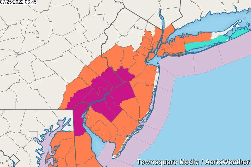
The National Weather Service has issued a Severe Thunderstorm Watch until 10 p.m. for almost all of New Jersey. (Excepting Sussex, Warren, and Morris counties which had thunderstorms early in the day, zapping any chances for late-day convection.)
There have been quite a few thunderstorm cells rolling through North Jersey so far. Some good soakers.
Now our attention turns to the "main event" — a broken line of strong thunderstorms that may produce gusty winds and heavy rain. (Hence, the Watch.) At this point, the most likely location for gusty, drenching thunderstorms will be the southern half of the state — along and south of Interstate 195. Although it is 90 degrees there, cloud cover may limit the intensity and spread of thunderstorm activity.
The ingredients are there — it's just a matter of whether the recipe comes together.
So, from the Delaware River to the Atlantic Ocean, please keep an eye on the sky and stay alert to changing weather conditions over the next several hours.
ORIGINAL POST from 7:02 a.m. Monday...
The Bottom Line
I'm sure I'm not the only one in New Jersey sick of heat and humidity at this point. Monday will be the 8th day in a row with 90+ degree temperatures in New Jersey. But a cold front is approaching that will provide sweet relief — a taste of slightly cooler and much drier air is less than 24 hours away.
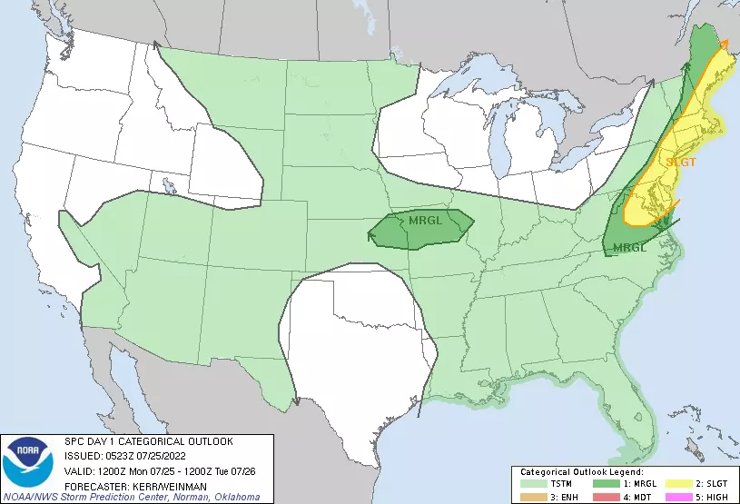
However, as usual, the heat wave grand finale will come with a round of turbulent weather. Thunderstorms. Severe weather. Downpours and wind. Monday is absolutely a "weather aware" and "eyes on the sky" kind of day.
Tuesday and Wednesday will turn "cooler," with seasonable highs in the 80s. But we will maintain unsettled weather throughout the workweek, with hit or miss showers, thunderstorms and downpours possible each day.

Monday
Steamy to stormy.
While I doubt temperatures records will be broken (like on Sunday), we still face dangerous heat for one more day. And the humidity is going to surge again, becoming pretty disgusting.
80 in the morning. Highs in the lower 90s. Heat index in the upper 90s to around 100 degrees. Stay cool, stay hydrated, etc.
We'll start the day with mixed sun and clouds and a stiff southwesterly breeze. Along the Jersey Shore, the surf is a bit churned up with 2 to 4 foot waves and a moderate risk of rip currents posted.
Now let's talk about thunderstorms, driven in by an approaching cold front and fueled by the abundant heat (energy) and humidity (moisture) in the air.
It looks like some showers and thunderstorms may creep into the northwest corner of New Jersey around the Monday midday hours. Those raindrops will actually help to 1.) limit high temperatures, and 2) limit the potential for even more potent storms later on.
The "main event" for strong to severe thunderstorms will be from mid-afternoon through early evening. Let's say 3 p.m. to 9 p.m.
Will everyone in the state see a thunderstorm Monday? Probably not. But everyone - including the coast - should stay alert to changing weather conditions and the possibility of severe weather.
My biggest concern with this line of storms is gusty winds, potentially bringing down trees, causing power outages, etc.
Second big concern is downpours causing ponding and flooding issues. Yes, we need the rain. But 2 to 3 inches of rain in a short period of time is just too much.
The tornado threat is not zero, but it is limited.
After showers and storms exit the coast Monday evening, we'll see partial clearing overnight. Our new air mass will be slow to arrive, so it will still be rather warm and sticky. Low temperatures will bottom out around 70 degrees Tuesday morning.
Tuesday
No more 90s! But highs will still reach the lower to mid 80s — summer-ish and warm. I think the big difference will be in the humidity. As dew points potentially descend into the 50s, the air will become much more comfortable and breathable.
However, that cold front is going to stall just south of New Jersey. That boundary will provide a "highway" for additional impulses and storm systems through the rest of the week.
On Tuesday, that means we could see a few spotty showers around, especially in South Jersey. They'll be very much hit or miss — I think there's a real chance most of NJ stays completely dry. Severe weather is not a concern.
Skies will be mostly cloudy to overcast on Tuesday too.
Wednesday
In terms of temperatures, humidity levels, and cloud cover, Wednesday will be very similar to Tuesday. Mostly cloudy and seasonably warm mid 80s.
Models are picking up on two thunderstorms chances on Wednesday too — one in the early morning, and one in the late evening hours. Either one could be a real soaker
Thursday & Friday
You didn't think we were done with 90s for July, did you?
A west-southwest wind will carry in a wealth of warmth and humidity on Thursday. High temperatures will push into the lower 90s. Even the coast will be toasty. And there could be a late-day popup thunderstorm.
Friday looks very similar. Partly sunny, chance of a popup storm, highs near 90.
The Extended Forecast
If all goes well — if everything plays out during the workweek as I have described — the weekend will be fabulous. Temperatures scale back to the 80s again. (Note: I wouldn't rule out another "technical" heat wave with 90-ish degrees on Thursday, Friday, and Saturday.) Partly sunny Saturday, mostly cloudy Sunday, dry weather all around. And manageable humidity. What a great way to close out the month of July.
Next cold front and chance of rain would be early next week. Long-range models suggest that bigtime heat could surge again by next weekend.
Dan Zarrow is Chief Meteorologist for Townsquare Media New Jersey. Follow him on Facebook or Twitter for the latest forecast and realtime weather updates.
11 reasons why storm chasing in NJ is a very, very bad idea
All about 'Medusa' at Six Flags Great Adventure
More From 94.3 The Point


