NJ to feel Hurricane Dorian’s touch: 9 things to know about timing, impacts
Background
For 12 days now, we have been tracking the storm now known as Hurricane Dorian, ever since its tropical circulation formed in the south-central Atlantic Ocean. The next 48 hours are the critical time for us, as Dorian makes its closest pass to New Jersey. We are not going to see hurricane level conditions. We are not even going to experience tropical storm force winds (sustained 39+ mph). I still think my descriptions of yucky and nor'easter-ish weather are most appropriate.
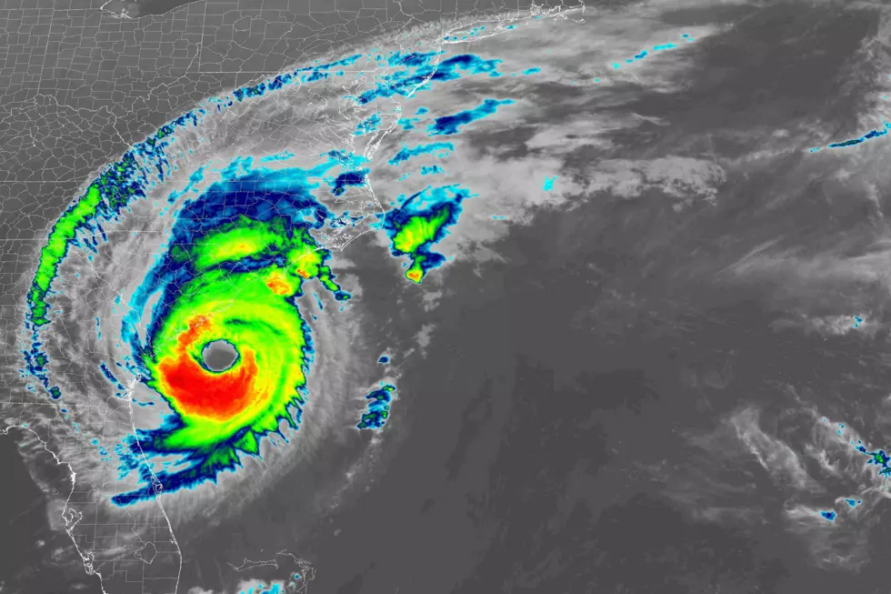
As of 5 a.m. Thursday, Dorian is a category 3 major hurricane with maximum sustained winds of 115 mph. The storm is centered about 80 miles south of Charleston, South Carolina — that is about 550 miles southeast of Cape May, New Jersey. For the rest of Thursday, Dorian will hug the coastline of South Carolina and North Carolina, potentially making one or more brief landfalls. (Especially along the various capes and barrier islands that jut out into the Atlantic Ocean.)
Latest guidance suggests Dorian's center will pass about 200 miles south of New Jersey, late-day Friday. The National Hurricane Center estimates that tropical storm force winds currently extend about 170 miles from the center of the storm (the radius). Boy that's close. Again, we're going to feel the storm, but I think the threat for truly dangerous conditions in New Jersey will be limited.
For the rest of this post, I want to give a no-nonsense, quick recap of what to expect from Dorian as it flies by.
Warnings
There are no Dorian-related watches or warnings in effect for New Jersey at this time. Unless there is a significant shift in the storm track, I do not expect that situation to change.
However, boaters and sea creatures should be aware that a Tropical Storm Warning is in effect for "west-central North Atlantic continental shelf and slope waters beyond 20 nautical miles off-shore".
Cloudy Skies, Cool Temps
See those clouds overhead? That's Dorian. As the storm approaches from the south, New Jersey will experience thickening clouds on Thursday. Meanwhile, we will be feeling the effects of Wednesday's cold front. So it will be cooler and less humid too — we have exited summery "shorts and t-shirt weather" for now.
High temperatures on Thursday will reach the mid 70s. On Friday, we'll be lucky to hit 70 degrees. That is about 10 degrees below-normal for early September.
Wind: Breezy to Blustery
A hurricane is a deep area of low-pressure. Meanwhile, high pressure is building over the Great Lakes. That intense pressure gradient is what causes such a large, strong wind field. Northeasterly winds may gust above 40 mph across southeastern New Jersey (in and around Atlantic and Cape May counties). Gusts to about 30 mph are possible through much of New Jersey. To the northwest (in and around Sussex and Warren counties), winds will be tamer with gusts to about 20 mph.
Those numbers represent what I believe is the most-likely scenario. It is important to note that South Jersey in particular will be right on the edge of some stronger winds near Dorian's core. One little wiggle northwestward in the storm track, and we could see some higher gusts enter the state. (Worst-case scenario, I've calculated as high as about 65 mph.)
It looks like the winds will really start to kick up early Friday morning, peaking Friday evening. Although winds will become less gusty, conditions will remain breezy on Saturday too.
Surge and Coastal Flooding: Minor to Moderate
It is clear that the Jersey Shore — especially the southern coast — will feel the most significant impacts of Dorian. That makes sense, as that's the area that will be closest to Dorian's powerful circulation, wind field, and rain bands.
Of course, another concern for the coast that doesn't affect inland NJ at all is storm surge, probably the greatest hazard of any tropical system. Those powerful east-northeast winds will push a lot of ocean water toward our beaches. A foot or two of surge is enough to cause minor coastal flooding across the Jersey Shore — that's where "the usual" low-lying areas and roadways near to tidal waterways experience water inundation at high tide. There is a chance that pockets of the coast experience 2 to 3 feet of surge, which would push tidal flooding into the moderate category — enough to necessitate even more road closures, and possibly cause some property damage.
The first high tide cycle we'll really have to watch will be Friday afternoon (2 p.m.) Water levels will be higher-than-usual for Saturday morning (2 a.m.) and Saturday afternoon (3 p.m.) as well. (Those are oceanfront high tide times — back bays and tributaries peak up to several hours later.)
Surf: Big Waves Battering Beaches
In addition to the surge, we're going to see some intense swell from Dorian, potentially spawning 6 to 10 foot waves along the entire Jersey Shore. A high risk of rip currents suggests that going in the ocean will be a very bad idea for the next few days. Moderate beach erosion is possible too.
Rain: Showery
As I've mentioned, rain is not our biggest concern. A few showers may bubble up from the south starting Thursday afternoon. Some steadier rain may impact the Garden State from Thursday night through much of Friday. It's hard to pinpoint how wet we get, since it's all about exactly where the bands set up and how far inland they move. I think a quarter-inch of total rainfall is a good estimate for most of New Jersey, with 1+ plus inches to the south and east.
While it's important to not underestimate the deep moisture of a tropical system, I really think tropical deluges are off the table for NJ.
A Farewell to Dorian
By the time you wake up Saturday morning, Dorian will be rapidly charging out to sea. Winds and seas will calm, the rain will exit (by 8 a.m.), and skies will clear by mid-morning.
In fact, the upcoming first full weekend of September looks pretty good with mostly to partly sunny skies and high temperatures on either side of 80 degrees.
The Rest of the Atlantic
Of course, it is important to always keep our eye on the big picture of the entire Atlantic basin. Dorian is still not alone:
—Fernand has become extra-tropical, after making landfall along the Gulf coast of Mexico on Thursday.
—Tropical Storm Gabrielle is still way out there in the eastern Atlantic. While it may intensify a bit, steering currents are expected to carry it north into cooler waters before threatening any land areas.
—A tropical wave just northeast of Bermuda has a small window to develop into a depression or named storm (60% chance). However, it should follow Dorian away from land, out-to-sea, into cooler waters.
—Another tropical wave coming off the African coast may or may not develop into a tropical system over the next few days. It's worth watching, but at least two weeks away from posing any kind of threat to the United States.
Be safe out there! As always, we'll be here when you need us, with the latest weather, news, and traffic updates.
More From 94.3 The Point


