NJ weather: Cold front to spark a breeze, showers, and a big cooldown
The Bottom Line
Wasn't Thursday just a perfect day? All three of New Jersey's climate reporting sites — Newark, Trenton, and Atantic City — hit a high temperature of 75 degrees. I love 70s and sunshine.
We will squeak out one more day of spectacular sunshine and warm temperatures on Friday. But our big weather headline is a cold front, the leading edge of a cooler, drier air mass. The timing of that front has slid a bit later, now set to arrive Friday evening. It will cause three weather changes for New Jersey:
1.) It will turn breezy, with gusts over 20 mph.
2.) A round of spotty showers is likely
3.) Temperatures get knocked back at least 15 degrees
That sets us up for a cool, but dry, weekend. Great weather for pumpkin picking, corn mazes, hayrides, and fall festivals. New Jersey's next widespread chance of rain down the line won't be until next Thursday-Friday.
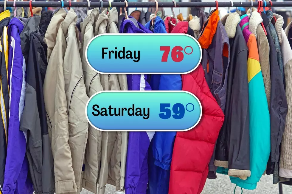
Friday
You might be able to leave the jacket at home Friday.
It is a comfortable cool start to the day, with temperatures mainly in the 50s. (Some pockets of 40s out there too.) Friday's daytime hours will be mostly sunny and warm, as high temperatures push into the mid 70s. I expect it to be a degree or two warmer than Thursday. And we are holding about 5 degrees above normal for early October.
As that cold front approaches, an isolated shower may popup in North Jersey around the late afternoon hours. The best chance for rain would be later though, in the late evening to overnight hours, firing up over central and southern New Jersey. I don't expect any heavy or prolonged rain. Maybe a tenth- to quarter-inch at the most.
It is going to become breezy Friday evening too, with some gusts over 20 mph. As winds become northwesterly overnight, temperatures will start to tumble. We'll end up in the chilly mid 40s by Saturday morning. I don't think we'll end up in the "frost zone" Saturday morning, given lingering raindrops, clouds, and the breeze.
Saturday
Definitely cooler, by at least 15 degrees. Back to jacket weather!
40s in the morning will only warm into the upper 50s by Saturday afternoon. Scattered clouds early on will lead to bright sunny skies in the afternoon. And the day will be completely dry. Just cool.
Saturday night to Sunday morning, we will have perfect radiational cooling conditions: Clear skies, calm winds, and a dry/cool air mass. That will allow temperatures to reach the bottom of the barrel, in the 30s and 40s. For the first time this fall, I do expect patchy frost to form in the coldest corners of the state. (It does not have to be "freezing" 32 degrees for ice crystals to form in the lowest inch of the atmosphere — 36 or 37 degrees is usually cold enough.
Sunday
Following the chilly, potentially frosty morning, thermometers will return to the 60s by the afternoon. Still below seasonal normals, but a nice day overall. Especially with the abundant sunshine.
Monday
The warming trend continues. 40s in the morning, upper 60s in the afternoon. Expect a mix of sun and clouds. And again, a rain-free day.
Tuesday & Beyond
Seasonable 70-degree temperatures will resume for Tuesday and Wednesday. Eventually, sun will turn to clouds. But no rain concerns yet.
Model guidance is painting a slow-moving cold front over New Jersey in the Thursday-Friday time frame next week. As it stands now, the forecast calls for periods of rain with embedded thunderstorms from Thursday midday until early Friday morning.
Dan Zarrow is Chief Meteorologist for Townsquare Media New Jersey. Follow him on Facebook or Twitter for the latest forecast and realtime weather updates.
These Scary Movies All Have an Interesting NJ Connection
10 NJ Frights Even Scarier than Horror Movies
Gallery Credit: Diana Tyler
More From 94.3 The Point