
NJ weather: Starting another active weather week with rain
Happy Monday! How nice it was to have quiet, seasonably cool weather over the weekend! (Especially after Friday, one of the craziest weather days of my career with the fog-rain-thunderstorms-wind.) Sure, there were a few conversational snow showers on both Saturday and Sunday. But it was nice to catch our collective meteorological breath.
We are kicking off another active weather week. But yet again in this tame winter season, the threat for wintry weather will be very limited.
As of this writing Monday morning, our next storm system is slowly creeping in from the west. Rain will first impact the northern and western edges of the state, eventually hitting the Jersey Shore by Monday afternoon. And with temperatures starting off above freezing, it's going to be all-rain for the duration.
So expect a generally wet day. But I don't think it will be a total washout for the Garden State, but it might be close — it all depends on where the axis of steady rain ends up. Rainfall totals (2-day) will end up between a half-inch and an inch — not quite enough to raise flooding alarm bells.
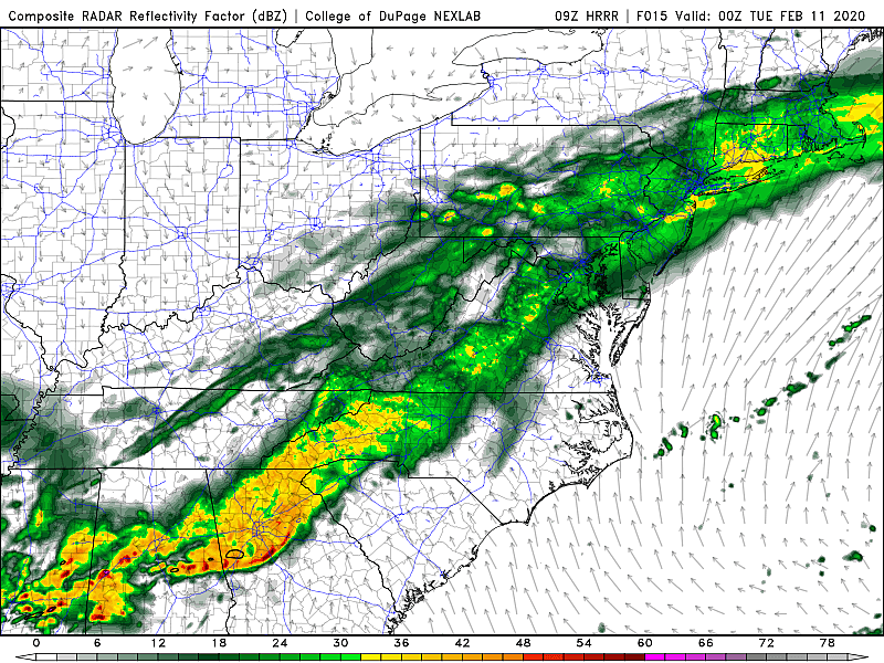
Winds might get a bit breezy or gusty at times. (Models have shown some 30+ mph gusts — nothing like Friday's fierce wind, but certainly worth a mention.) High temperatures Monday will reach about 45 to 50 for all but far northern New Jersey.
Monday night will be wet too, with temps falling only a few degrees into the lower 40s.
We'll keep scattered light rain in the forecast Tuesday morning. This storm system will finally exit and rain will finally taper off by Tuesday afternoon. High temperatures should spike to around 50 degrees on Tuesday. (Although don't expect much, if any, sunshine.)
Wednesday will be slightly cooler, with highs limited to the lower to mid 40s. Mostly cloudy to overcast skies will persist for most of the day. And then, before you know it, our next storm system rolls in — and this one could get interesting.
Models show first raindrops arriving between Wednesday late afternoon and Wednesday dinnertime (between about 4 p.m. and 8 p.m.) As temperatures drop Wednesday evening, it could get cold enough for some light snow and/or wintry mix in northern New Jersey. I'm especially eyeing the area north of Interstate 78 for a quick taste of wintry weather, but I wouldn't rule out snowflakes as far south as Interstate 195. As for accumulations, my gut says the threat will be very limited. But raw model data is suggesting minor snowfall, on the order of an inch or two. Bottom line, this won't be an overly impactful "winter storm," just something to watch for now.
As showers wrap up Thursday morning, we'll finally see skies clear out. High temperatures on Thursday will be as warm as 60 degrees (in South Jersey). But that's not going to last long, as arctic air makes an appearance and temperatures tumble dramatically. (A rare occurrence this season!)
Friday is Valentine's Day, and it's going to be frigid. Friday morning's low temperatures could dip into the single digits (in North Jersey). And with a brisk wind, northerly in the 15 to 25 mph range, the wind chill ("feels like" or "apparent" temperature) could fall below zero. That combination of cold and wind presents the danger for frostbite and hypothermia, so it's important to take it seriously.
High temperatures on Friday afternoon could be stuck in the 20s. That is almost 20 degrees below normal for mid-February. And if my latest forecast holds, it would be New Jersey's coldest day in over a year, since February 1, 2019. Hey, at least skies will be bright and sunny.
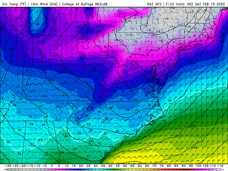
We'll do a little better Saturday afternoon, with mostly sunny skies, dry weather, and lower 30s.
And 40s return to thermometers on Sunday, as our next storm system rolls in late-day. Given that warmup, it looks like just rain for now.
Bottom line: Brace yourself for another week of crazy weather! (Although hopefully not as crazy as last week.) From rain to snow, from relative warmth to bitter cold. From umbrellas to snow shovels (eh, not really) to t-shirts (again, not really) to winter parkas. Enjoy, stay warm, and stay safe!
Dan Zarrow is Chief Meteorologist for Townsquare Media New Jersey. Follow him on Facebook or Twitter for the latest forecast and realtime weather updates.
More From 94.3 The Point


