NJ weather: Timeline of rain, wind, cooldown, and possible snowflakes
The Bottom Line
Thursday looks good. But big changes arrive in New Jersey with a strong cold front and an active weather day on Friday. Umbrellas up and windshield wipers on!
By the end of the upcoming weekend, you might be reaching for a heavier coat, with a wintry chill in the air. Easily the coolest air of the season so far.
One More Nice, Mild, Dry Day
I wish we could "copy and paste" Tuesday's and Wednesday's weather a few more times. Blue skies, comfortable temperatures, mainly dry weather. Lovely! But unfortunately, that's not how meteorology works.
The chill is back in the air Thursday morning, with some spots across inland New Jersey seeing a frost or even a light freeze to start the day. Closer to the coast and to urban areas, it is a bit warmer, in the 40s and 50s.
High temperatures will reach into the lower 60s Thursday afternoon. Not as warm as the past two days. But still running about five degrees above seasonal norms.

Skies will be mostly cloudy, but we'll stay dry and calm and pleasant through the daytime hours.
As humidity rises and clouds continue to thicken, temperatures will be tricky Thursday night. It looks like thermometers will dip a few degrees between sunset and midnight, before rising to about the 60-degree mark between midnight and daybreak.
The Rain
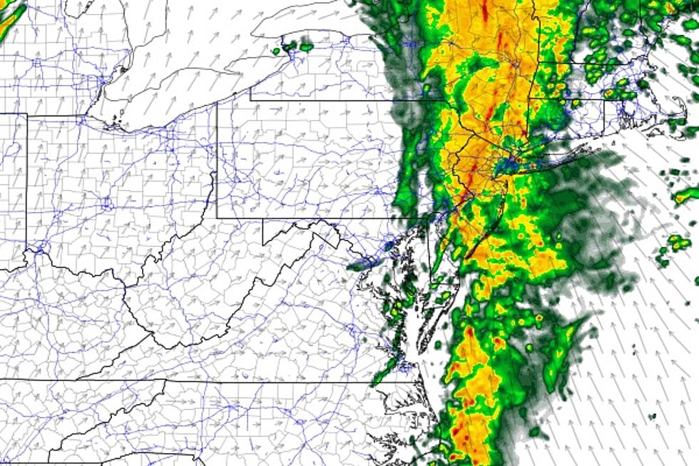
A shower may creep into New Jersey starting around 10 p.m. Thursday evening. And then we really get soaked Friday morning, as a band of steadier, heavier rain sweeps from west to east across the entire state between about 6 a.m. and 2 p.m. (It looks like the heaviest stuff will fall toward the later end of that time window.) Showers may linger through late Friday afternoon, but they'll become widely scattered and relatively light.

Model guidance for rainfall has gone up. Total rainfall will likely end up just below an inch in South Jersey. Farther north, we could see a bit more, possibly over 1.5" in the bucket. Since that rain will be falling in a short 3 to 6 hour period of time, raising the potential for some ponding and flooding issues.
Meanwhile, there will be enough warmth, moisture, and instability in the air to sustain some elevated embedded thunderstorms. You may notice some rumbles of thunder and extra wind gusts as the heaviest rain blows through Friday morning. But I do not expect widespread, dangerous severe weather here.
The Wind
Between the heavy rain and the eventual arrival of a cooler air mass, a period of elevated wind is a guarantee. Forecast models show top gusts approaching 40 mph around Friday midday and afternoon. There could be some sporadic power outages. And that's certainly strong enough to add a "blustery" or "nasty" characteristic to the day.

Saturday looks breezy, if not gusty, too. That westerly wind will continue pushing colder air into New Jersey.
The Cooldown
The first day of November was mild (high of 64 degrees at Newark Airport). The following six days turned quite chilly (56, 56, 54, 55, 56, 57). November 8th through the 10th were wonderfully warm and pleasant (68, 74, 69). And the temperature forecast for Thursday (62) and Friday (67) remains on the mild side too.
But here comes the big cooldown, arriving just in time for the weekend.
Saturday morning won't be horrible, with lows in the 40s. I could see some patchy frost forming, but only in the coldest corners of NJ: Northwest and Pine Barrens.
Saturday will be noticeably cooler, but really we're only getting knocked back to more November-ish levels. My forecast puts high temps Saturday afternoon between the lower 50s (North Jersey) and the upper 50s (South Jersey and the coast). Some models do push out some 60s, but I think it's just too warm given the clouds, wind, new air mass, and rain chance. (More on that in a moment.)
Sunday is going to have a wintry chill in the air. A morning frost/freeze is likely away from the coast. And we'll see high temperatures only around 50 degrees. That's almost more typical of early December than mid November. And it could be reason to reach for a heavier coat, hat, and/or gloves.

The unseasonably cool weather will continue for early next week, with highs in the upper 40s for Monday and Tuesday. Hopefully things will moderate into the 50s and even 60s for the second half of next week.
Additional Showers
Two weak waves riding through our atmosphere will bring two additional precipitation chances to New Jersey over the weekend.
The first one will be the more prominent one. A quick round of scattered rain is expected Saturday afternoon. It won't last long, but it looks like there could be some pockets of moderate to heavy rain involved. Rainfall totals could hit a quarter-inch.

Now let's talk about the snowflake potential. On Saturday, because precipitation will occur during the warmest part of the day, the chance for snowflakes mixing in is very limited. I wouldn't completely rule out that potential in and around Sussex County, N.J.
Sunday night into early Monday morning, a few more light showers will clip through the Garden State. Hardly worth even a mention. But given the nighttime timing, there's a legitimate chance some of those showers will be of the snowy variety. Given the light intensity, I doubt it would be anything more than flurries. And accumulations or travel difficulties are not expected. However, first flakes of the season are worth a mention. (Especially since you know there will be many more snowflakes to come this winter season.)
Dan Zarrow is Chief Meteorologist for Townsquare Media New Jersey. Follow him on Facebook or Twitter for the latest forecast and realtime weather updates.
The 10 Most Stolen Vehicles In New Jersey
Gallery Credit: Jeff Deminski
9 of the nation’s most miserable cities are in New Jersey
Gallery Credit: Jeff Deminski
More From 94.3 The Point


