
NJ weather: What in the world is a “Red Flag Warning” and why should you care?
UPDATE as of 3 p.m. Thursday...
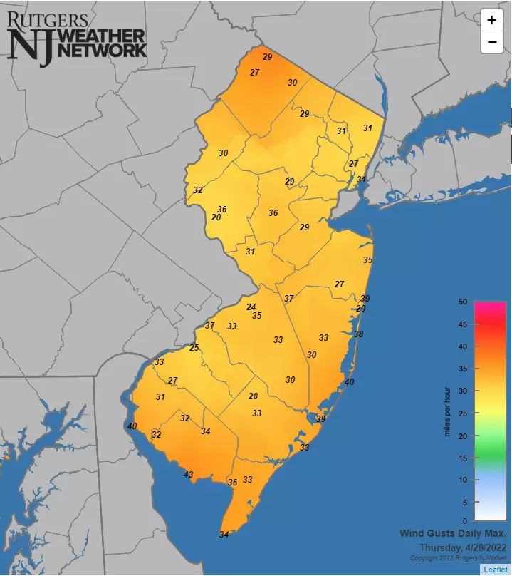
The winds are still whipping across New Jersey. According to the NJ Weather Network at Rutgers University, Thursday's top wind gusts have been in the 30 to 40 mph range. Definitely blustery. And definitely a concern for wildfire danger.
I have received a few comments that the wildfire danger is mitigated due to our recent rain soaking the ground. While that may be true, the other two ingredients of the fire danger formula - strong winds and dry air - are just as important for explosive wildfire growth. That's why we still have the Red Flag Warning for Thursday. And a Fire Weather Watch for Friday.
Keep reading for more details. And stay warm out there.
ORIGINAL POST from 6:06 a.m. Thursday...
The Bottom Line
The combination of dry air, dry brush, and strong winds raise the concern for wildfires. So the National Weather Service has issued a Red Flag Warning for all 21 counties of New Jersey for Thursday. That doesn't mean the Pine Barrens are going to spontaneously combust on Thursday. But those conditions can lead to rapid spread of wildfires, and would make firefighting efforts very difficult. Outdoor burning (including a casual "flick" of a cigarette) is a terrible idea.

Meanwhile, weatherwise, temperatures will be stuck below normal for a few more days. And winds will remain elevated too. But we do have a stretch of sunny and completely dry weather ahead. Our next threat of raindrops is four days away (Monday).
Thursday
Cool and blustery.
Thursday morning is starting off in the 30s across the vast majority of NJ. Some wind chills have even dipped into the 20s. You'll definitely want a sweater or jacket heading out the front door. Four weeks ago, Thursday morning's temperatures would have been totally typical. So we're not talking about a "dead of winter" kind of cold snap here. But it's still unseasonable and rather unusual.
High temperatures Thursday afternoon will only reach the mid 50s, at best. That is about 10 degrees below normal for late April. Wind gusts could top 30 mph for part of the day, keeping the cool air mostly around. There could be a few clouds early on, then sunshine will dominate the sky. And again, there is a zero chance of precipitation.
Thursday night will be just as cold as Wednesday night, with lows in the lower to mid 30s for most of the state. Patchy frost or even a light freeze are possible, away from cities and the coast. It will be clear, with a chilly breeze.
Friday
Not as cool, but still breezy.
30s in the morning, then 60 for an afternoon high. Not bad, but still 5 degrees below seasonal norms. It will be sunny and dry. And still breezy too, although top gusts look to only reach about 20 to 25 mph.
In addition, the threat of explosive wildfire growth will be present again on Friday. A Fire Weather Watch is currently posted, which will likely become a warning Friday morning.
Saturday
The warmup continues.
The final day of April looks pleasantly springlike. We'll have more sunshine and (finally) lighter winds. High temperatures will push into the lower 60s.
Sunday
Even though clouds will increase on Sunday, temperatures will keep rising too. And we should stay dry (during the daytime hours, at least).
Highs on Sunday should reach the upper 60s. 70 degrees is a possibility. It will be our first "above-normal" day in over a week (April 22nd).
The Extended Forecast
The warmup will continue next week, likely ending up mainly in the 70s. I think we could even see a few 80s around by midweek.
However, next week will turn a bit unsettled too, with approximately three rounds of rain pushing through the Garden state.
Best chance of wet weather next week will be 1.) early Monday morning, 2.) early Wednesday morning, and 3.) late Thursday to early Friday. That late-week storm system will probably produce the steadiest, most widespread rain of the bunch. (Of course, as always, we'll give you a detailed "play-by-play" of the forecast as it becomes clearer.)
Dan Zarrow is Chief Meteorologist for Townsquare Media New Jersey. Follow him on Facebook or Twitter for the latest forecast and realtime weather updates.
Smoke from West Coast Wildfires Reaches New Jersey
2022 Seaside Heights Polar Bear Plunge photos
Gallery Credit: Andrew Miller/For Townsquare Media NJ
More From 94.3 The Point


