NJ’s weather goes downhill Monday: Rain, wind, coastal flooding, limited snow
The Bottom Line
There's a bunch of hype swirling around a coastal storm system set to impact New Jersey starting Monday afternoon.
Yes, it's going to get rainy and windy.
Yes, we could see one round of coastal flooding along the Jersey Shore.
Yes, there's even a limited chance of late-season snow or wintry mix in northwestern New Jersey.
Yes, you could technically call this a nor'easter. (Although given the dramatic, wintry connotations of that term, I'd prefer not.)
In the end, we face a period of inclement and inconvenient weather developing across New Jersey on Monday. Nothing earth-shattering, or inherently dangerous.
Let's run through the details, grab the umbrella, and get on with our day.
Rain
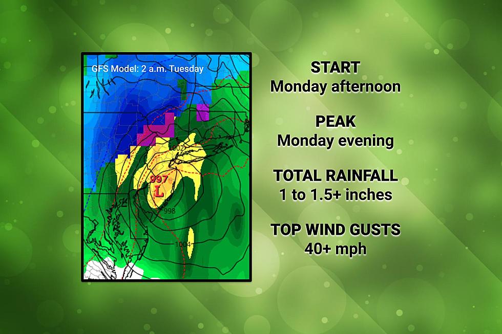
—First Raindrops... 11 a.m. to 3 p.m. Monday (southwest to northeast)
—Peak (Heaviest Rain)... 6 p.m. Monday to 4 a.m. Tuesday
—Tapering Off... Midnight to 6 a.m. Tuesday (again, southwest to northeast)

—Total Rainfall... 1" to 1.5" looks likely for most of NJ, with locally higher amounts (up to 2") possible
—Flooding Risk... During downpours, low-lying and poor-drainage areas could experience ponding and flooding issues. Road conditions may go downhill significantly toward the end of Monday evening's commute.
—Thunder/Lightning Potential... Low
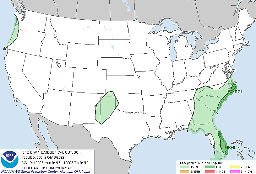
—Severe Weather Threat... Low (including severe wind, hail, and/or tornado)
Wind
—Ambient Wind... Becoming increasingly breezy during the day Monday, initially out of the east-southeast at 10-20 mph.
—Brunt of the Storm... Between about 8 p.m. Monday and 4 a.m. Tuesday, east-northeast gusts will peak as the storm system's center passes by NJ.
—Top Gusts... 40+ mph, highest along the coast.
—Impacts... Sporadic power outages are possible. Downed trees, branches, and wires could cause road issues. Lawn furniture and garbage cans may become projectiles.
Coastal Flooding
Any time there is a powerful storm system over the western Atlantic Ocean, we have to consider the possibility of storm surge. Especially when strong winds are at play.
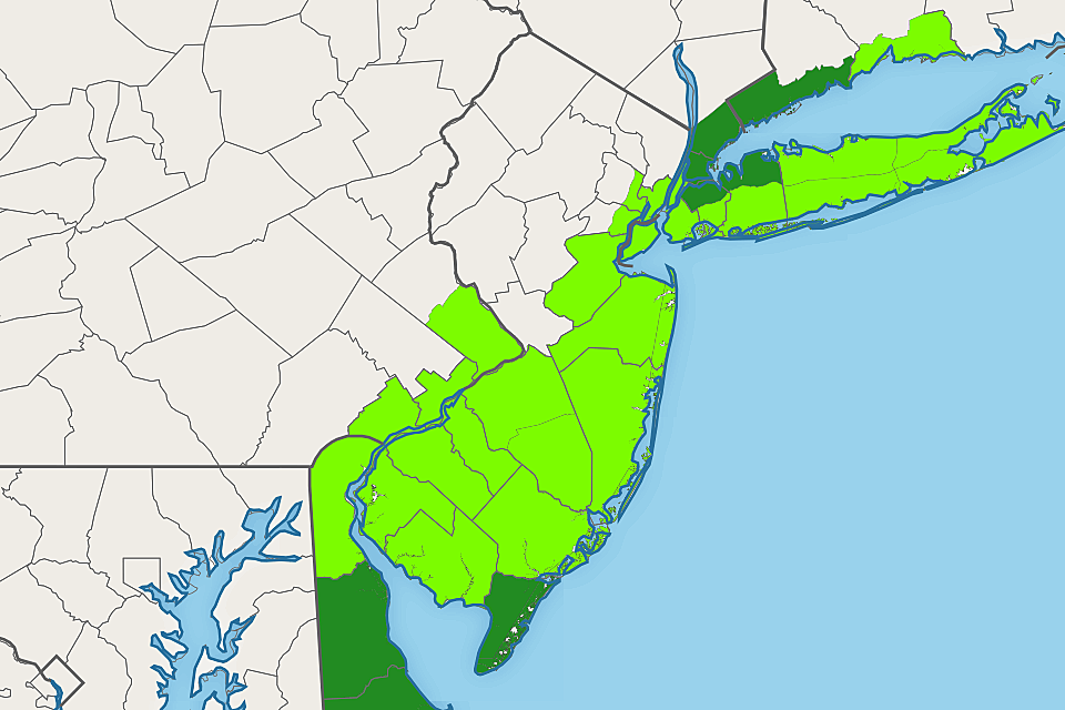
The latest tidal models are in. And it looks like we are going to face one round of coastal flooding at the Jersey Shore, during Monday evening's high tide cycle. (Around 9 p.m. on the oceanfront, several hours later along back bays and tributaries.) An extra foot or two of water will be enough to cause widespread minor to localized moderate flooding of tidal waterways. That may necessitate road closures and detours, particularly in spots that "always" flood during a big storm.
A Coastal Flood Warning has been issued for Cape May County, in effect from 7 p.m. Monday to 3 a.m. Tuesday. A Coastal Flood Advisory is posted for the rest of the Jersey Shore, including areas along the Delaware Bay, up Delaware River, and up the Hudson River basin too.
Remember to never attempt to drive, walk, or swim through flooded areas.
Snow
It is tricky. Both the GFS and Euro models have been very consistent for about a week now, suggesting a period of snow in NW NJ from this storm system Monday night. And yes, that potential is still alive. In fact, just north of New Jersey, the recent intrusion of cold air has New York and New England ringing alarm bells for several inches of snow accumulation. Winter storm warnings have been issued from the Poconos to the Catskills to the Adirondacks.
Here in the Garden State, I think the development of substantial snow or wintry will be limited. We're really just talking about the "usual" area for any snowflakes — north of I-78 and west of I-287. And temperatures would only be cold enough for wintry mix during the overnight hours — after 8 p.m. Monday.
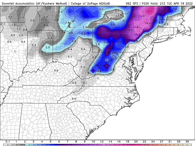
As for the accumulation potential, I think it's fair to also call it very limited. The ground is quite warm — 5-centimeter soil temperatures are at or above 50 degrees now. And again, temperatures both at the surface and aloft would only sustain snowfall for a short period of time.
Could we see a healthy coating to an inch along the hilltops of Sussex, Morris, and Warren counties by Tuesday morning? Maybe — if the snow comes down hard enough to overcome that warm ground. Do I expect snow for "most" of New Jersey? No. Do I expect substantial travel issues for Tuesday morning's commute? No.
Can I believe we're still talking about accumulating snow on the 18th of April? Eh, I guess so. It's rare this late in the season, but not totally unheard of.
Extended Forecast
High temperatures for both Monday and Tuesday will be similar to Sunday, stuck in the lower 50s. That's about 10 degrees below-normal for this time of year. And a far cry from anything resembling "springlike" or "comfortable" or "mild" weather.
Skies will brighten on Tuesday, but it will stay pretty blustery.
Wednesday looks good, as high temperatures approach 60. Recent forecast model runs have spit out a rain shower chance on Thursday, but the latest data suggests it will fizzle and we catch a mainly dry (although mostly cloudy) day.
Highs will spike to 70-ish on Friday, before our next storm system arrives for the final full weekend of April. At the moment that looks to bring scattered rain showers on Saturday, followed by cooler, more seasonable weather for early next week.
Dan Zarrow is Chief Meteorologist for Townsquare Media New Jersey. Follow him on Facebook or Twitter for the latest forecast and realtime weather updates.
NJ beach tags guide for summer 2022
Gallery Credit: Heather DeLuca
NJ county fairs are back! Check out the 2023 summer schedule
Gallery Credit: Mike Brant
More From 94.3 The Point


