
Storm #1 update: Monday looks sloppy, with rain and some wet snow
This storm is NOT the big one
Just to be crystal clear — I am only talking about Monday's storm in this post. It is the first of two systems aiming for New Jersey this week. And it almost certainly will be the less impactful one.
The next system upstream is the one to really watch, in the Wednesday-Thursday time frame. It's still too early for concrete details on that potential nor'easter — although significant snow, rain, wind, and coastal flooding are looking very likely. Sunday afternoon, I will publish a breakdown of what we know (and what we don't) for that one.
Overview
As colder air returns to New Jersey and the entire Northeast Sunday night into Monday, an area of low pressure will churn through Virginia. So the Garden State will be on the northern side of the storm system — the colder side. But temperatures will not quite support an all-snow/ice event. Still, up to an inch of rain in South Jersey and limited snow/ice/slush accumulations in North Jersey will make for a sloppy day overall. Especially since the worst weather will come during the middle of the day.
Timeline
First raindrops will push in from the west around mid-morning Monday (9 a.m.) Initial precipitation may be snow or mix in far northern New Jersey (if the storm reaches up that far).
Starting midday (Noon), as temperatures continue to crash, rain will change to snow along and northwest of the NJ Turnpike corridor.
Precipitation will taper off as the storm departs in the early evening hours (5 p.m.)
Accumulations
Unsurprisingly, the critical pieces of this snow accumulation here are 1.) when the changeover from rain to snow happens, 2.) how quickly the snow sticks to the (wet) ground, and 3.) how hard the snow falls and accumulates. I think we have pretty good model consensus regarding #1. #2 always seems to happen faster than expected. So for "the sweet spot" where accumulation actually occurs, this forecast hinges on #3, snowfall intensity.
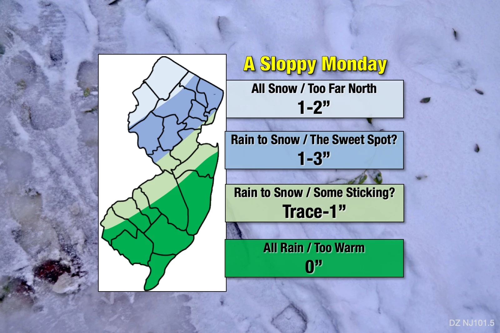
Please refer to the forecast map above for a visual depiction of our latest snowfall forecast:
—Too Far North... For northern New Jersey, around Sussex and Warren counties, it will likely be cold enough for snow (or at least wintry mix) at onset. However, the center of the storm system will be 300 miles away. So I'm not sure substantial precipitation bands will make it to North Jersey to accumulate tons of snow. I've limited this corner of the state to the 1-2" range for now.
—The Sweet Spot... In the area generally northwest of the Route 1 corridor, rain will quickly change to snow by lunchtime, accumulating through the afternoon. There could be some minor travel impacts in this section, with 1-3" of fresh snow on the ground by the end of the day.
—Some Sticking... By the end of the storm, the rain-snow line may drift as far south as the I-195 corridor and as far east as the I-295 corridor. Although probably the most uncertain piece of this snow forecast, let's not rule out a healthy coating and/or some slippery spots through southwestern and central NJ.
—Too Warm... Southern and coastal New Jersey, this ain't your storm. Well, it is if you like rain, rain, and more rain. Don't expect anything wintry — but a cold, uncomfortable rain will still make for a rather yucky day.
If anything, I think I'm leaning conservative with my snowfall estimates here, especially in the northern quadrant of the state. Previous model estimates of snowfall were considerably higher for this storm, in the 4-8" range. But the forecast has trended warmer and tamer over time. So, while I wouldn't rule out some over-performance — an isolated report of 4 inches, perhaps — I do not think New Jersey is facing a major snowstorm here.
Impacts / Action Steps
Overall, Monday is going to be a rather unpleasant and sloppy day across the state, no matter what's falling from the sky. But still, it's a minor winter weather event — no big snow, no flooding, no coastal flooding, no wind. (Of course, the Wednesday-Thursday storm will be a different matter.)
The worst part of this weather event? It's happening right in the middle of the day. A "9 to 5" storm. Which means weather and road conditions will be drastically different between the morning and evening commutes.
This will also be a dynamic storm system. Falling temperatures forcing a change in precipitation type adds a certain "fuzziness" to the forecast. It's going to be very important to stay alert to changing conditions. (And keep a close ear to the latest forecast too!)
So what should you do to prepare for Monday? Possibly nothing. At the very least, consider any travel plans carefully (including commuting to/from work/school). Dig the shovels and cold weather gear out of storage if you haven't already.
Next Update
My next forecast blog update is planned for mid Sunday afternoon. As I mentioned, that one will focus mainly on the high-impact midweek storm. But I'll certainly update Monday's sloppy forecast too.
Dan Zarrow is Chief Meteorologist for Townsquare Media New Jersey. Follow him on Facebook or Twitter for the latest forecast and realtime weather updates.
The 10 Best Sunrises in Seaside Park
More From 94.3 The Point


