
Storm #2 update: Midweek nor’easter looks like major storm for NJ
The Bottom Line
A high-impact winter storm — a nor'easter, in fact — will impact New Jersey from Wednesday to Thursday this week. Heavy snow accumulations are becoming increasingly likely for inland New Jersey. But there's a lot more in play here than just snow — heavy rain along the coast, potential icing, strong winds, coastal flooding, and extreme cold.
Even with just 72 hours to go until the storm arrives, it is still premature to be discussing concrete details like snow accumulations and the exact timeline. There are two reasons why we're not talking numbers yet:
1.) One storm at a time. New Jersey faces a minor rain/snow event coming up on Monday. The ultimate track and impacts of the first storm could absolutely affect the bigger storm. (In addition, concentrating on one storm at a time makes communicating weather hazards easier and clearer too.)
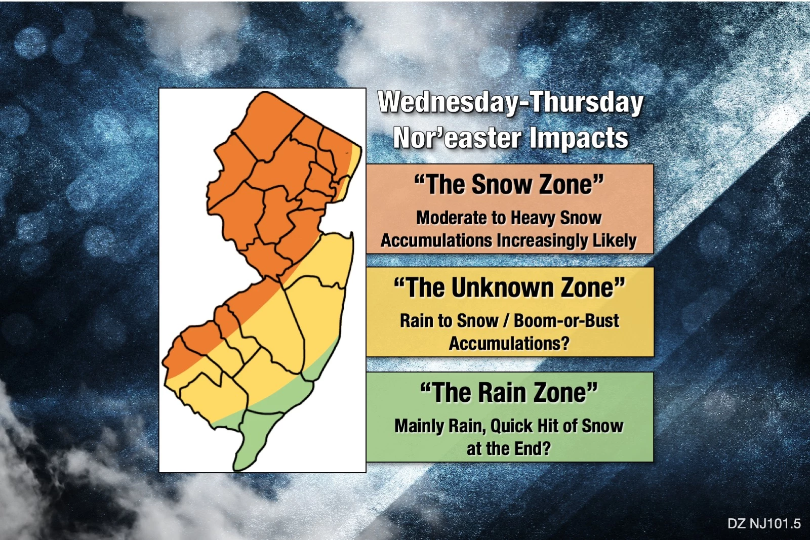
2.) This forecast is a nightmare. Given the track and temperature profile, it looks like we're going to have an incredibly tight "boom or bust" gradient in snow totals. You may literally be able to drive ten miles inland from the coast, and you'll go from zero snowfall to over a foot on the ground. One little "wiggle" or "wobble" in the storm track, one little miscalculation, and the forecast becomes a complete bust.
On Saturday, I threw out the half-joking notion that New Jersey could see "0 to 28 inches of snow". (And boy did I get torn apart on social media for that!) Let me rephrase: It is totally possible that opposite ends of New Jersey will see both 0 inches of snow and 20+ inches of snow. Where's the line? That's the puzzle we have to piece together between now and Wednesday.
Background
This is shaping up to be a pretty classic nor'easter. An area of low pressure (a storm system) digs through Virginia and North Carolina, ejecting out over the Atlantic Ocean. As it does, the system curves up the Atlantic seaboard, strengthening over the open water. A big dome of sinking air (blocking high pressure) over Canada serves as both steering mechanism and source of cold air.
Nor'easters are so named because of the predominant northeasterly wind direction such a track produces over New England and the Mid-Atlantic. Most of New Jersey's biggest blizzards have come from nor'easter type storms. And then can produce the full meteorological spectrum of winter weather hazards: snow, sleet, freezing rain, rain, wind, flash flooding, coastal flooding, and extreme cold.
There is good reason this week's storm is getting so much attention. It could be a beast!
Timeline
There are still some differences in the exact timing of the onset, transition (rain to ice to snow), peak, and tapering of this dynamic storm system. But here's a first stab at what I'm thinking, for the precipitation at least:
—Start... First flakes and drops arrive around midday Wednesday.
—Peak... Conditions go downhill Wednesday evening, with the worst weather coming late Wednesday night.
—End... Wrapping up sometime Thursday morning.
Keep in mind, we'll refine that further (with actual times) in the coming days. Additionally, the timing of the non-precipitation impacts (wind, surge, cold) will be different.
Snow
Once snowfall exceeds 6 or 7 inches, I think you'll agree that the impact on New Jersey's roadways and infrastructure is pretty significant. So, by that definition, New Jersey is practically guaranteed "major" snow on Wednesday-Thursday.
Just how high will those totals go though? Model guidance has consistently pumped out "double-digit" snowfall totals (10+ inches) for a large swath of inland New Jersey. Sometimes even suggesting 20+ inches — not unprecedented from a winter storm, but certainly impressive!
Who gets clobbered with the most snow? As I depicted above, the area along and west of the NJ Turnpike is most likely to see the most snow. However, the freezing line will be constantly in motion during the storm, especially as temperatures drop Wednesday evening. Snowfall is highly uncertain in that "unknown zone" farther south and east. Could be boom (a lot) or bust (not much).
So what's the forecast? We just can't call it right now. There are so many factors still in play: The strength of the high, the track of the low, timing, temperatures at the surface, temperatures aloft, and so on.
Rain
It is totally possible that the Jersey Shore won't see a single flake of snow, as temperatures stay (barely) above freezing for the duration. Upwards of 2 inches of cold rain will be quite unpleasant and comfortable. And could lead to visibility, traction, and ponding issues.
Ice
A strong, dynamic storm system like this one, which causes rapid cooling throughout the atmosphere, has the potential to produce Mother Nature's most precarious precipitation types: sleet and freezing rain. Some models have hinted at the possibility of such icing, which adds another layer of slipperiness and heft to heavy snow.
For now, just know the possibility of ice is there. Thunder and lightning too. This is a layer of detail we'll focus on more later.
Wind
A rapidly intensifying area of low pressure is forecast to pass just a few miles off-shore. Of course there's going to be gusty winds. Right now I'd put top gusts in the 40 to 50 mph range.
Combine wind with the heavy weight of snow and ice, and power outages are a real concern. Those depending on electricity for work-from-home or remote-learning arrangements could have problems on Thursday. Loss of heat could be a big problem with the subsequent cold weather too.
Coastal Flooding
We're just starting to get estimates of potential storm surge — tidal models only look 72 hours out. And I don't like what I see.
2 to 3 feet of surge would probably cause widespread water inundation issues along the Jersey Shore. Timing will be extremely important here — hopefully, the strongest wind (and surge of ocean water) will occur at low tide, which is around 2 a.m. Thursday morning.
If you live, work, or commute along tidal waterways, you'll want to watch this piece of the forecast very, very closely.
Cold
If you're hoping for an immediate warmup and quick melt after the storm, think again. The coldest air of the season so far will settle in through the end of the week. By Friday, we'll see widespread teens in the morning and only 30s in the afternoon. Yeah, that's cold.
UPDATE... Winter Storm Watch
As of 7:15 p.m. Sunday, the National Weather Service issued a Winter Storm Watch in advance of the Wednesday-Thursday storm.
The watch specifically mentions the possibility of 12+ inches of snow accumulation in Hunterdon, Morris, Somerset, Sussex, and Warren counties. And 5+ inches for NW Burlington, Camden, Gloucester, Mercer, Middlesex, western Monmouth, and Salem counties.
That is in line with the "red" area of my impacts map above. These watches will likely become warnings on/about Tuesday.
What's Next?
I realize it is frustrating to only have an empty shell of a forecast here, for what looks like a significant winter storm. But please understand this is such a dynamic, low-confidence, boom-or-bust forecast. If I were to offer any real detail, it's guaranteed it would be wrong. And I'd much rather be right than first.
I've got a full day ahead in the weather center on Monday covering storm #1. I will probably issue an actual snowfall map for Wednesday-Thursday in the morning, with a subsequent update later on.
We're already starting our internal preparations at the radio station (staffing, supplies, etc.) You should consider your plans for Wednesday-Thursday very carefully at this point too.
Dan Zarrow is Chief Meteorologist for Townsquare Media New Jersey. Follow him on Facebook or Twitter for the latest forecast and realtime weather updates.
SNOW STATS: When is the last time it really snowed in NJ?
August 19th Monmouth County Tornado Damage
More From 94.3 The Point