
Thursday NJ weather: Soaking, gusty, noisy thunderstorms return
UPDATE as of 2:30 p.m. Thursday...
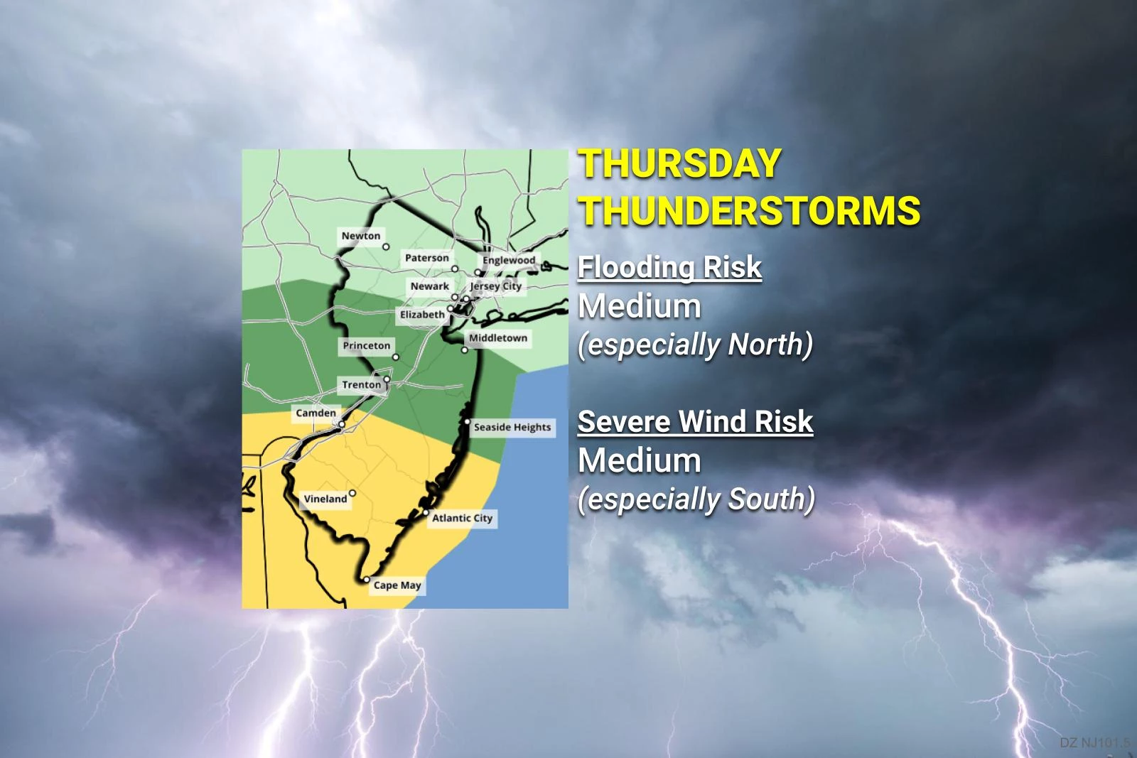
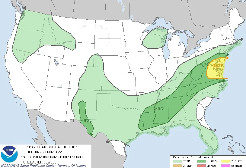
A Severe Thunderstorm Watch has been issued until 9 p.m. Thursday for 10 counties in New Jersey, from Mercer and Monmouth on south. A watch is a formal "heads-up" that the ingredients are coming together in the atmosphere for powerful, potentially dangerous storms. The area corresponds with the half of the state that has 80+ degrees — the "juiciest" air in the state.
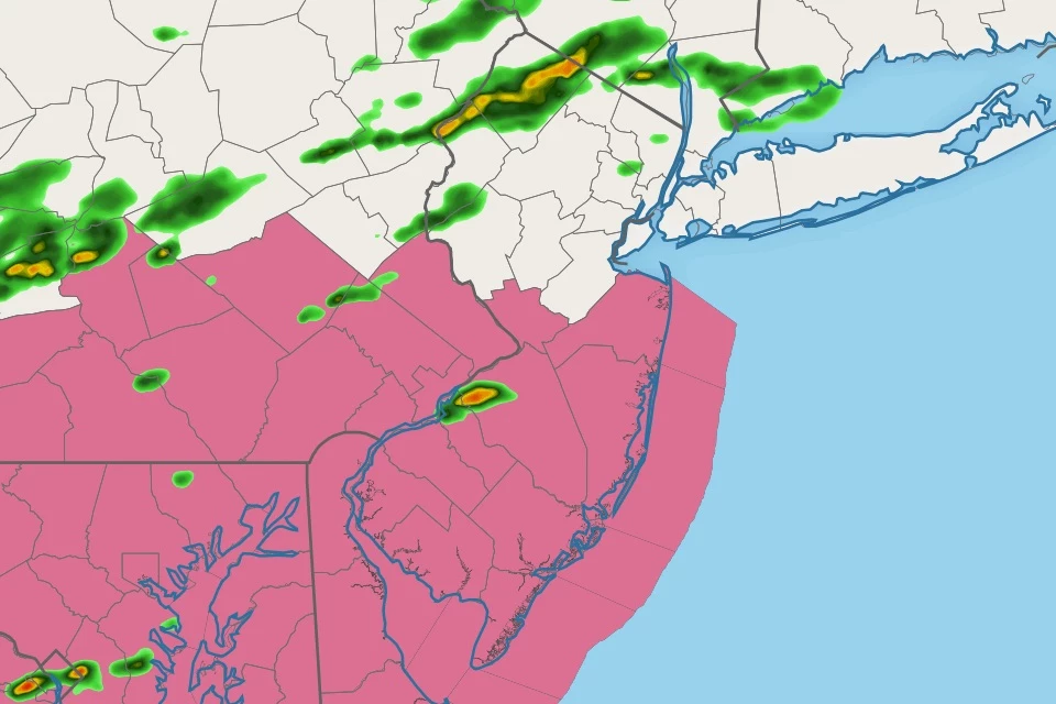
Storms have started to develop, especially in waterlogged North Jersey so far. Our weather is likely to turn nasty statewide over the next few hours.
The biggest concern is for gusty winds — hence, the need for a watch. Heavy rain may lead to flooding too. Wicked lightning and small hail are also possible.
Keep an eye on the sky through Thursday evening, and be prepared to seek shelter in a sturdy building if storms arrive and/or warnings are issued.
ORIGINAL POST from 6:55 a.m. Thursday...
The Bottom Line
The forecast for Friday, Saturday, Sunday, and even Monday is splendid. Sunshine, low humidity, seasonably warm temperature. But we have to get there first.
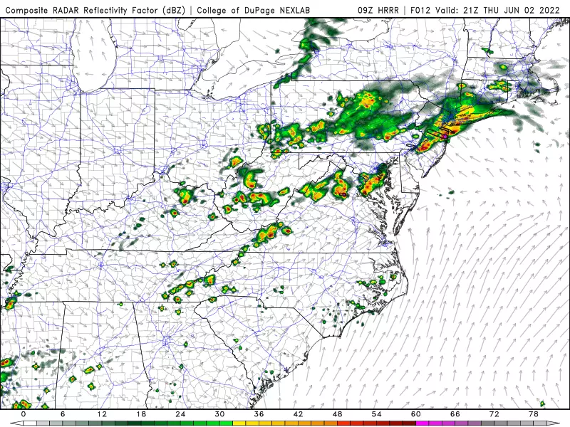
Wednesday's storms held together way better than expected. Radar suggests upwards of 5 inches of rain fell over North Jersey over the last 24 hours. The thunder and lightning were intense, with some spotty wind damage around too.
We're going to do it all over again on Thursday, as strong storms develop in the afternoon and evening hours. This time around, however, it will be an entire-state affair. Top concerns will be drenching rain (especially in North Jersey) and gusty winds (especially in South Jersey).
By definition, every thunderstorm produces lightning. Therefore, every thunderstorm is potentially dangerous. It is important to stay "weather aware" Thursday, keeping alert to changing weather conditions. If warnings are issued, seek shelter inside a sturdy building.
Thursday
As of this writing (6 a.m.), overnight storms have exited the Garden State. We still have some patchy fog and mist and wet roads. Temperatures are starting out in the 60s, with moderate humidity in the air.
The first part of Thursday looks OK — you might squeeze out some "beach" or "outside" time. Mostly cloudy to the north. Brighter partly sunny skies to the south.
Temperatures on Thursday will be a bit more sensible and diurnal. Highs will end up around 80 degrees — but there's a lot of "give and take" with that number. We'll end up in the 70s in NW NJ and along the Jersey Shore. But SW NJ will probably soar well into the 80s, making for another summerlike day.
The differences in 1.) Wednesday's stormy weather, and 2.) Thursday's sky cover and temperatures means the inevitable thunderstorms will carry different concerns for opposite corners of the state.
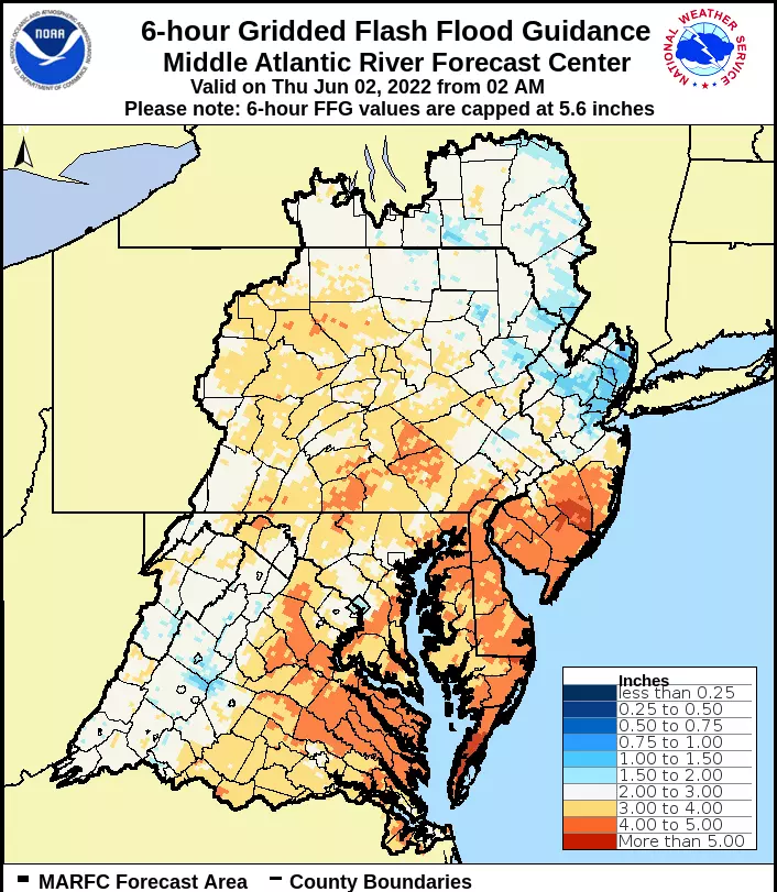
A few showers may creep in from the west at any time. It looks like things will really start firing up in North Jersey around the early afternoon hours. And because the ground is so saturated there, it won't take much heavy rain to cause ponding and flooding issues. Some models are pumping out a swath of 2+ inches of storm total rainfall.

Meanwhile, those storms will develop southward into central and coastal New Jersey by late Thursday afternoon. South Jersey might stay dry and storm-free through early evening. However, the atmosphere over the southern half of the state will be unstable and juicy, allowing for some severe storm cells. Gusty wind is the big worry here — the hail and tornado risk are relatively low this time around.
Bottom line: Rain plus wind plus lightning will make for a pretty nasty situation Thursday afternoon and evening, no matter where in the state you are.
Storms will fade away by late evening, although showers may linger until well after Midnight. It's going to stay pretty sticky and humid after the rain ends. Overnight low temperatures will only dip into the lower 60s.
Friday
And so begins a beautiful stretch of weather.
Humidity levels will steadily drop throughout the day Friday, as drier, more comfortable air arrives. Skies should quickly clear to sunshine. And we'll see seasonably warm high temperatures in the upper 70s. Truly a pleasant early June day.
Saturday
Not much to say here. With high pressure in control of our atmosphere, it will be another sunny, dry, warm day. Highs will once again end up around the upper 70s.
Sunday
Still great, although some clouds will creep into the sky. I'll push high temperatures down into the mid 70s because of it. We will stay dry for another day.
The Extended Forecast
I'm 50/50 about Monday. It may be just as nice as the previous three days, with a bright sky and temperatures between 75 and 80 degrees. There is a chance of a shower popping up on forecast models, so that's something to watch.
New Jersey's next substantial chance of rain will come in the Tuesday time frame. Scattered showers and thunderstorms are possible throughout the daytime hours.
One important item to watch for that next rain chance is the development of a storm system just off the Yucatan Peninsula of Mexico. That cluster of showers may organize into a tropical storm over the next day — the first name on the list for 2022 is Alex.
While all model guidance keeps "future Alex" away from New Jersey, we could still feel some indirect impacts from the storm. Enhanced rainfall and dangerous rip currents come to mind. Just something to watch in the medium- to long-range.
Dan Zarrow is Chief Meteorologist for Townsquare Media New Jersey. Follow him on Facebook or Twitter for the latest forecast and realtime weather updates.
11 reasons why storm chasing in NJ is a very, very bad idea
Gallery Credit: Dan Zarrow
BEEP BEEP BEEP: These are the 13 types of Wireless Emergency Alerts auto-pushed to your phone
Gallery Credit: Dan Zarrow
More From 94.3 The Point


