Tuesday NJ weather: Sideswiped by gusty thunderstorms, more warmth ahead
The Bottom Line
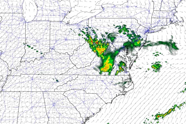
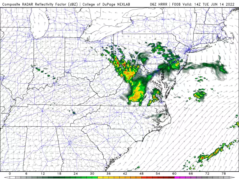
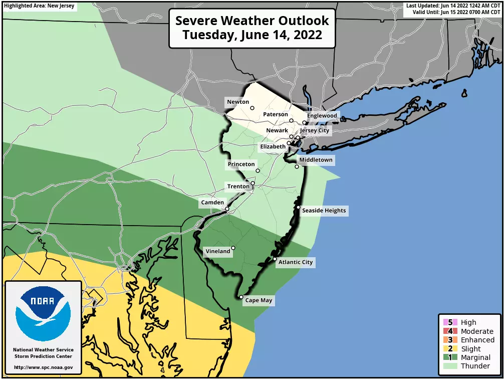
Tuesday's big weather headline is a cluster of thunderstorms — a Mesoscale Convective System — scraping past New Jersey. The worst weather will stay well south and west of New Jersey. However, part of the state is facing some stormy weather, including some heavy rain, gusty winds, and frequent lightning. At the very least, we'll be close to some nasty weather — it's a good idea to keep an eye on the sky Tuesday.
Meanwhile, warm, humid weather roll right along this week. Although Tuesday is unsettled, Wednesday will be pleasant and summer-ish. Our next rain chances for Thursday and Friday will be minimal, but again there could be some more thunderstorms around.
We're also gaining clarity on the Father's Day Weekend. And the forecast is still looking great.
Tuesday
As of this writing (6 a.m.), the main cluster of thunderstorms we're watching is diving through Ohio, West Virginia, and Pennsylvania. There is one concerning piece of energy approaching Lancaster, Pa. — about 70 miles west of New Jersey. That will push into the southern half of the state starting mid-morning, around 8 or 9 a.m.
If the storm cell holds together, a period of heavy rain, gusty winds, and wicked lightning is likely south of about Interstate 195.
Additional pockets of rain may clip western and southern New Jersey through the midday hours. By about 1 or 2 p.m. at the latest, we'll be able to put all rain chances behind us.
It's important to note that it's not going to rain everywhere in NJ on Tuesday. And even to the south, it's certainly not going to storm all day. The entire state should transition from clouds to sun by late afternoon.
Pinpointing Tuesday's high temperature is tricky. It depends a lot on how much rain you get, and when the sun comes out. I think areas in the "storm zone" of South Jersey will see upper 70s. Dry spots will probably push into the lower 80s again. That gives us an average of 80 degrees — not far off from "normal" for mid-June.
Tuesday night will be fairly uneventful weather-wise. It will be clear and dry, with low temperatures falling into the lower to mid 60s. Just a hint of stickiness in the air.
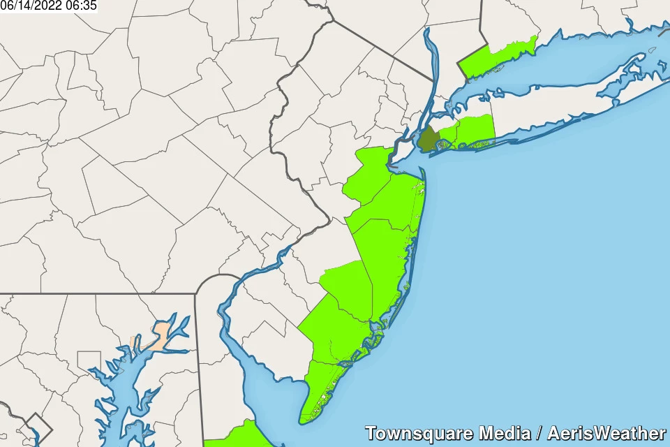
There is a Coastal Flood Advisory posted for the Jersey Shore for the Tuesday evening high tide cycle. Due largely to the full moon, a round of minor tidal flooding is possible.
Wednesday
Well to our south — in Virginia, the Carolinas, and Georgia — some intense heat is building this week, with temperatures in the 100s. Here in New Jersey though, we're doing fine. With a nice, warm, summer-ish day on deck for Wednesday.
Expect mostly sunny skies, moderate humidity, and high temperatures in the lower to mid 80s. The wind will shift to a southeasterly (on-shore) direction in the afternoon, forcing temperatures along the coast down late-day (toward 70 degrees).
Thursday
The flip-flopping between "nice" and "not" will continue on Tuesday, as skies become mostly cloudy again. A stiff south-southeast breeze will pick up. And temperatures will turn a bit cooler, only reaching the upper 70s or so.
Additionally, our next rain chances will come into play Thursday. But they look pretty minimal. A few showers and thunderstorms are possible Thursday morning. And then again Thursday evening, a thunderstorm may visit. At the moment, I do not see the need to ring alarm bells for severe weather or flooding.
Friday
The hottest day of the week. Highs will surge into the lower 90s away from the coast, as we tap into that steamy southern air mass. But it's only temporary.
Friday is also a cold front day. That frontal boundary is currently forecast to push across New Jersey around midday Friday. (That timing is very much subject to change.) As it does, spotty thunderstorms are possible. (Models are pretty meager on rain chances Friday, but given the heat and humidity and strength of the front, I can't imagine we'd stay completely storm-free.)
Any storms on Friday should be brief. Skies will clear while temperatures and humidity start to drop into Friday evening.
The Weekend & Beyond
The next 12 weekends are precious — summer is almost here, and it's definitely "Shore season" already. At this point of the year, I don't care what Mother Nature throws at us during the week. As long as Saturday and/or Sunday we catch some great weather for outdoor activities.
And that's exactly what's shaping up this time around, for the upcoming Father's Day Weekend. The entire weekend looks sunny and dry. Humidity will be nice and low. High temperatures are expected to end up just shy of seasonal normals, in the mid to upper 70s. Saturday might be a little breezy. Overall, there is a lot to like about the weekend forecast.
Of course, the pleasantries can't last forever. Rain returns to the forecast early next week — around the Monday-Tuesday time frame.
Dan Zarrow is Chief Meteorologist for Townsquare Media New Jersey. Follow him on Facebook or Twitter for the latest forecast and realtime weather updates.
11 reasons why storm chasing in NJ is a very, very bad idea
Gallery Credit: Dan Zarrow
BEEP BEEP BEEP: These are the 13 types of Wireless Emergency Alerts auto-pushed to your phone
Gallery Credit: Dan Zarrow
More From 94.3 The Point


