
Wednesday NJ weather: Summer ends with one more nice, warm day
The Bottom Line
Happy last full day of summer. We are about to "fall" into fall, as the Autumnal Equinox officially arrives on Thursday evening at 9:04 p.m.
And a strong cold front will lead to a big weather transition as the season changes. This forecast progresses from warmth on Wednesday, to rain on Thursday, to a chilly autumn wind on Friday.
The time for swimming pools, shorts, and air conditioning is about to come to an end. Have the umbrella handy for Thursday. And then get those jackets and hoodies ready for Friday and beyond.
Wednesday
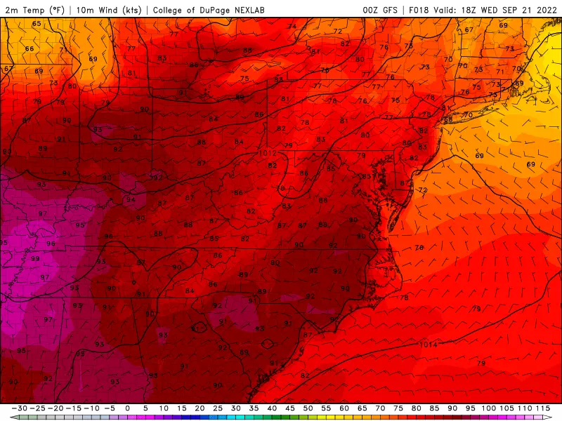
Soak in the sunshine, with some fair-weather clouds dotting the sky Wednesday. Just like Tuesday.
And temperatures will be fairly similar too. We're starting out in the 50s (inland) and 60s (cities and coast). High temperatures will reach the lower 80s for most of the state Wednesday afternoon. That is about 5 to 10 degrees above normal for this time of year.
Even Wednesday night stays pretty quiet. A stray shower is possible, especially in North Jersey. Otherwise, expect increasing clouds and increasing humidity. It's probably going to feel a bit sticky, with low temperatures averaging upper 60s by Thursday morning.
Thursday
Everyone in New Jersey will get wet. You'll probably need the umbrella and windshield wipers for a few hours. But it will not be a total washout. And I really don't need to ring alarm bells for potential severe thunderstorms, flooding, and/or wind.
Raindrops will likely begin in North Jersey before sunrise Thursday morning. The wet weather will then progress toward the southern coast by Thursday late afternoon. So, in the "middle" of the state, you'll see rain through the "middle" of the day. There could be some stronger storm cells and pockets of heavier rain along the way. Rainfall totals will probably average a half-inch statewide.

In general, it just won't be a pretty day. Mostly cloudy, wet, and eventually breezy.
High temperatures on Thursday are tricky, dependent on the arrival time of the rain and the (eventual) cooler air. North Jersey will probably be stuck in the 60s all day. Most of NJ will peak in the 70s. South Jersey might touch 80 degrees, before temps tumble into the 70s too.
By dinnertime Thursday, we should start to see some clearing overhead. And temperatures will tumble. If skies clear fast enough and dew points drop far enough, we could see widespread 40s across interior New Jersey by Friday morning. Back to jacket weather!
Friday
40s and 50s in the morning. And highs will only reach the lower to mid 60s. It's not just going to feel like fall, it's going to be a positively October-ish day.
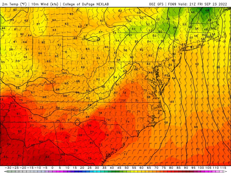
Skies will be mostly sunny. And the wind will be brisk and blustery, blowing out of the northwest between 15 and 25 mph. Occasional gusts over 30 mph are possible.
Saturday
Our weather settles down as we dive into the first weekend of autumn. But Saturday will still have a definitive "fall fell" in the air.
Under partly sunny skies, high temps should improve to about 70 degrees. Winds will be considerably lighter. And both our weather and air will be completely dry.
Sunday & Beyond
Clouds roll back in Sunday. And we're warming up again, to the upper 70s (at least).
One hiccup for Sunday will be a few rain showers in the afternoon and early evening hours.
High temperatures settle into the 70s for early next week. Good looking weather as we look toward the end of September.
The Tropics
The Atlantic has fired up so much, tropical weather deserves its own section in this morning's weather blog post!

Major Hurricane Fiona is packing maximum sustained winds of 130 mph — Category Four on the Saffir-Simpson scale. It is scraping along the eastern edge of the Bahamas on Wednesday, aiming for Bermuda next. And then potentially making landfall in eastern Canada this weekend.
Fiona is going to spit out some big surf and swell, dramatically churning up the waves along the Jersey Shore over the coming days. (I'm glad the weather is turning cooler, so the beaches become far less popular.)
Tropical Storm Gaston is way out in the Atlantic, heading toward the Azores and eventually Europe. Little chance of intensifying. And no threat to North America.
Finally, a strong tropical wave will pass from the Atlantic to the Caribbean over the next 24 hours. It is expected to organize into a tropical storm and possibly a hurricane in the coming days. (The next name on the Atlantic hurricane list is Hermine.)
That storm is absolutely worth watching, as it could have impacts on the U.S. within the week. Lots of directions it could go, ranging from the Gulf Coast to the Carolinas. And most of those options could have some weather/surf impact on New Jersey within 7 to 10 days. Stay tuned on this one — hurricane season is far from over.
Dan Zarrow is Chief Meteorologist for Townsquare Media New Jersey. Follow him on Facebook or Twitter for the latest forecast and realtime weather updates.
Say you’re from Jersey without saying you’re from Jersey
Gallery Credit: Jeff Deminski/Townsquare Media
Each State in America and Their Favorite Type of Cereal...
Gallery Credit: Jimmy G
More From 94.3 The Point


