
Friday NJ weather: Cool temps, brisk wind, rough surf
The Bottom Line
Welcome to the first full day of fall! I love the meme going around suggesting "The temperature went from 80 to 65 like it saw a state trooper!" That's exactly what happened — Friday will be a full 15+ degrees cooler than Friday. Even running well below normal for late September.
A brisk wind will be the big weather nuisance on Friday, keeping the cool air moving around. The ocean will also be very angry, due to increased swell from Hurricane Fiona.
The last weekend of September will bring moderating temperatures and calmer winds. Our weather turns a bit unsettled on Sunday, with some showers in the forecast.
That is our one and only substantial rain chance for the next week though. Fall is all about cool temperatures and incredibly dry air.

Friday
It's cool. Although Friday morning is not quite as cool as expected, thanks to a thin layer of clouds and a light breeze. We are starting the day in the 50s.
There are also a few very isolated showers and sprinkles showing up on radar. That's from the northwest wind carrying moisture our way from Lake Ontario. (It's the same mechanism that can cause snow squalls after a cold frontal passage.)
Other than that, we'll see lots of sunshine Friday. High temperatures will only reach about 60 to 65 degrees. NW NJ will likely be stuck in the 50s all day.
It will be windy too, blowing out of the northwest up to 20-30 mph. That will add a blustery characteristic to the day, keeping the cool air moving around. Likely jacket weather all day.
With mainly clear skies, calming winds, and insanely dry air, Friday night looks quite chilly. We'll probably average mid 40s by Saturday morning. There could be some 30s in the northwest hills and possibly the Pine Barrens — close to the frost point, but not quite there.
One more important note about Friday... A High Surf Advisory is posted for the Jersey Shore, technically in effect from 6 a.m. to 8 p.m. (So... all day.) Hurricane Fiona is making its closest pass to NJ, sliding just west of Bermuda. And it's spitting out some heavy swell. 5 to 8 foot ocean waves will make surf conditions very dangerous. A high risk of rip currents is posted. Beach erosion is possible. However, widespread coastal flooding is not expected to be a concern. (Water levels for some may reach flood stage, especially with a New Moon this weekend.)
Saturday
Saturday will be more comfortable than Friday. Once temperatures warm up a bit from those chilly 40s early on, that is.
Highs will pop to around 70 degrees, with sunshine and some passing clouds. It will be a dry air, dry weather day. And winds will be considerably lighter than Friday.
With some clouds overhead and a hint of humidity in the air, Saturday night won't be quite as chilly. We'll probably bottom out in the 50s. Still jacket-worthy, feeling much more "September-ish" than "October-ish".
Sunday
Warming up even more, to the upper 70s. Maybe even 80 degrees in South Jersey. So we swing back to above normal, for one day at least.
Skies will become mostly cloudy Sunday. And a storm system will produce a round of scattered showers and thunderstorms. The rain may get in the way of part of your Sunday — especially around the early evening / dinnertime hours. But it's not a huge, all-day thing. Rainfall totals will probably stay less than a quarter-inch.
Monday
A weak cold front will knock back temperatures on Monday. It will be breezy. But mid 70s with sunshine should make for a nice day.
The Extended Forecast
Next week looks pretty quiet. New Jersey will be on the southern edge of a storm system. We will have to watch for potential showers, but I favor a dry forecast for now. High temperatures probably on the cool side, in the 60s or 70s each day.
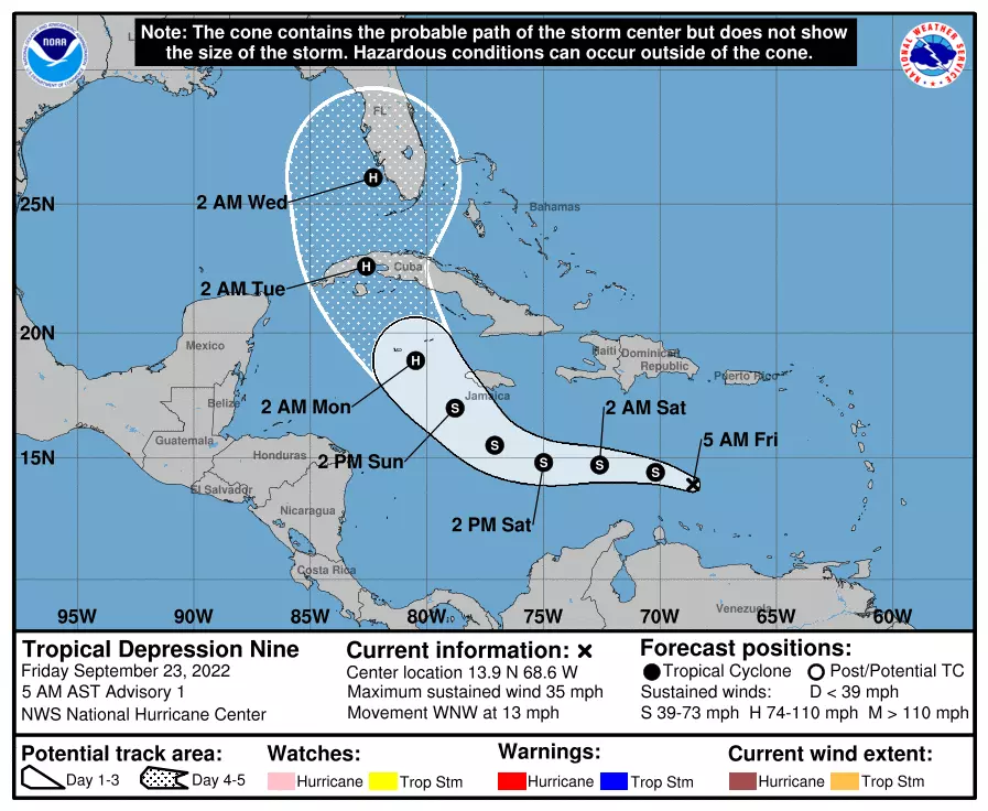
One thing we have to watch closely is the development of newly upgraded Tropical Depression #9 in the Caribbean. It will likely strengthen into a tropical storm as it enters more open waters. (The next name on the list is Hermine.) And the model consensus track now has the storm clipping the western edges of Jamaica and Cuba before aiming for the Florida Gulf Coast.
Still lots of time for the system to wiggle and decide exactly where it's going. Where it makes landfall along the U.S. Gulf Coast will largely impact what direct or indirect impacts head our way. If it happens, that is still more than a week away — sometime around the first few days of October.
Dan Zarrow is Chief Meteorologist for Townsquare Media New Jersey. Follow him on Facebook or Twitter for the latest forecast and realtime weather updates.
A little slice of Jersey (and U.S.) history: A look at Cowtown Rodeo
POP QUIZ: Can you name all 10 interstate highways in New Jersey?
More From 94.3 The Point


