
Here we ‘snow’ again: Winter Storm Watch for NJ, Thursday-Friday
What's New?
—Overnight, forecast model consensus shifted our impending winter storm slightly southward. That is a slightly colder and snowier solution.
—Those models have also come into much better agreement regarding the timing of the start, peak, and wintry mix transition.
—Having said that, the end time of this storm system is a bit hazy now — precipitation could linger over New Jersey through much of Friday.
—I remain very concerned that icy mix (sleet and freezing rain) will be the ultimate "snow buster," especially across for the southern half of the state.
—You'll notice I tweaked my snowfall contours slightly to the south. And I added an area covering the southern coast. But I'm opting to kick any significant shifts down the road to the next update.
—The bottom line remains the same: No matter where in New Jersey you are, Thursday will become wintry and messy.
Wednesday
Quiet, although cold. Wednesday morning temperatures are in the 20s, with an icy wind pushing the wind chill ("feels like" temperature) into the single digits and teens. Wind dies down, sun comes out, and high temps only reach about the freezing mark Wednesday afternoon. Clouds will start to increase late-day.
Storm Timeline
—Early Thursday Morning (2 a.m. to 6 a.m.)... A few snow showers will overrun the Garden State. Dry air will make it difficult for those flakes to reach the ground, and only minimal accumulation is expected by sunrise Thursday.
—Mid Thursday Morning (6 a.m. to 10 a.m.)... A burst of steady snow will spread from southwest to northeast. Once flakes start to fall, conditions will go downhill quickly, with moderate to heavy snow likely for several hours.
—Midday Thursday (10 a.m. to 1 p.m.)... The brunt of the storm continues, with heavy snow bands delivering 1+ inch an hour snowfall. Meanwhile, warming in the mid-atmosphere will cause a transition from snow to wintry mix along the southern coast.
—Thursday Afternoon (1 p.m. to 5 p.m.)... The mixing line will continue to drift north, as mid-level warmer continues. Still snowing (north) and sleeting (south) pretty steadily.
—Thursday Night to early Friday Morning (5 p.m. to 5 a.m.)... Precipitation intensity should lighten up through the evening and overnight hours. Southern and coastal NJ transition to rain. Central NJ falls under wintry mix (snow, sleet, and freezing rain) for most of the overnight. Northern NJ should keep light to moderate snow, with some sleet potentially mixed in.
—Friday Daytime (5 a.m. to 5 p.m.)... A surge of colder air will enact a final transition to more snow and sleet, rather than freezing rain and rain. Previously, I was hoping precipitation would end in the early morning hours. But I'm not so sure now — wintry mix could persist into part of the afternoon.
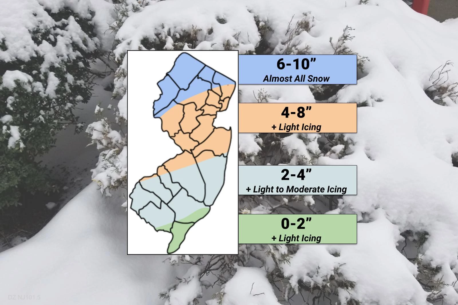
Accumulations
—6 to 10 inches of almost all snow to the north.
—4 to 8 inches of healthy snowfall between Philly and NYC. Based on 00Z model guidance, I was so tempted to bump the entire northern half of the state to a 6-10" forecast. But the sleet. Oh, the sleet! I'm still very concerned that warming in the mid-atmosphere will force that transition to icy mix as far north as about the I-78 corridor Thursday night. That will put a swift end to accumulation, and possibly cause a light glaze of ice.
—2 to 4 inches for most of South Jersey. A substantial period of mixing and icing (due to sleet and freezing rain) and dry-slotting will be issues south of a line between Bellmawr and Belmar. (I always wanted to mention those two towns in the same sentence!) A quarter-inch of ice accumulation is possible here, which is quite significant.
—0 to 2 inches for the southern coast, with a quick burst of snow at onset, then wintry mix and plain rain through the rest of the storm. Depending on the length and makeup of that mix, there could be some light icing concerns.
In addition, some models are still pushing an additional 1-2" of snowfall during the day Friday. Eh. Given the fuzziness of the end time, and the unknown of whether that snow will actually stick to the ground, I opted to stay conservative for now.
Coastal Flooding
Tidal guidance shows about a foot of storm surge on Friday. That's enough to cause minor flooding of coastal waterways for one or both high tide cycles on Friday.
Winter Storm Watch
No change to our watch, in effect for inland New Jersey from Thursday morning through part of Friday.
What's Next?
—I can't wait to see what the 12Z model suite does with the mixing line. I want to see good consensus about the northern edge and timing of that surge of mid-atmosphere warmth and sleet and freezing rain. Only then will I feel more confident about who'll get solid snow and who'll get busted.
—Expect the National Weather Service watch to be upgraded to warnings and advisories by Wednesday afternoon. Who gets what will depend on 12Z model output.
—Next weather blog update will come by about 5 p.m. Wednesday, with more details and specifics, and an updated snow/impacts map.
—I'll publish one more weather blog update early Thursday morning with my final call.
—As always, we'll have on-air and online updates for the duration of the storm.
Dan Zarrow is Chief Meteorologist for Townsquare Media New Jersey. Follow him on Facebook or Twitter for the latest forecast and realtime weather updates.
YUM: Fast food items you love that are no longer around
More From 94.3 The Point


