How could Hurricane Ian affect NJ’s weather later this week?
UPDATE... This article is outdated...
For the latest storm forecast information, please refer to my newest weather blog post.
The Bottom Line
As of 5 a.m. Monday, Ian is officially a hurricane. The storm continues to strengthen over the Caribbean Sea — a full 1,500 miles away from New Jersey.
I decided to strategically frame this post's headline around Hurricane Ian for two reasons. First, a lot of New Jerseyans are already talking about and watching the storm. And second, there is really not much else going on in our weather world.
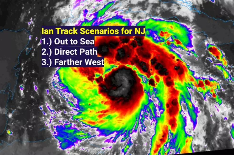
Tropical weather forecasting is very delicate — we have to play out these forecasts very slowly and carefully. This far out, finite forecast details are just too hazy to talk about confidently. Still, in this article, I want to lay out the three Ian scenarios that I believe could play out for New Jersey later this week. Possible impacts range from tropical rainfall to nothing at all.
The Short-Term Forecast
Sunday was a rather unsettled weather day across New Jersey, with a few rounds of heavy rain and noisy thunderstorms. Some spots in the state picked up over an inch of beneficial rainfall.
All's clear on radar Monday morning, although I have seen reports of patchy fog. Temperatures are starting out in the comfortable 50s across most of the state, with some 60s along the southern coast. Will you need a jacket? Maybe, maybe not. (For the record, I personally left it at home this morning.)
High temperatures Monday will reach the mid 70s. Very similar to Sunday, and close to the long-term average for late September. We'll enjoy plenty of sunshine and a fresh southwesterly breeze (20+ mph). With some unsettled weather just to our north, I can't rule out a few spot showers. Especially in the late afternoon to early evening hours. But most of NJ should stay dry and pleasant all day.
Monday night also looks uneventful. Let's call it partly cloudy and comfortably cool. Low temperatures will dip into the mid 50s — again, typical for this time of year.
On Tuesday, we flip back to sunshine. And it'll probably be breezy again for part of the day. The air will turn slightly cooler and drier. High temperatures will be limited to around 70 degrees.
And we'll hold on to slightly-below-normal temperatures through the final few days of September. Wednesday will feature increasing clouds and highs near 70. For Thursday, expect a mix of sun and clouds with highs around the upper 60s.
By Friday, we may have to start watching for clouds to bubble up from the southwest, in advance of Ian. Until (and unless) it rains, temperatures will hold steady. Again, high temperatures will flirt with 70 degrees to close out the workweek.
Ian Background
As of 5 a.m. Monday, Ian was upgraded to a category 1 hurricane, with maximum sustained winds of 75 mph. It was centered about 90 miles southwest of Grand Cayman and 315 miles southeast of the western tip of Cuba. That puts it about 1,500 miles away from New Jersey.
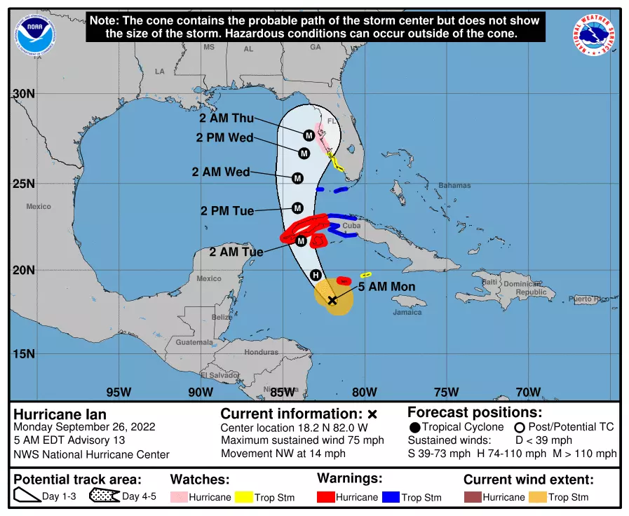
The storm will barrel through the western half of Cuba Monday night, and is expected to reach the Florida Gulf Coast Wednesday into Thursday. Possibly as a Major Hurricane (> 110 mph). Bad bad news.
As it makes landfall in Florida, the exact track and trajectory of the storm will directly affect when and how the storm may ultimately impact New Jersey. There are several possible outcomes on the table at this point, with so much time and distance left to travel.
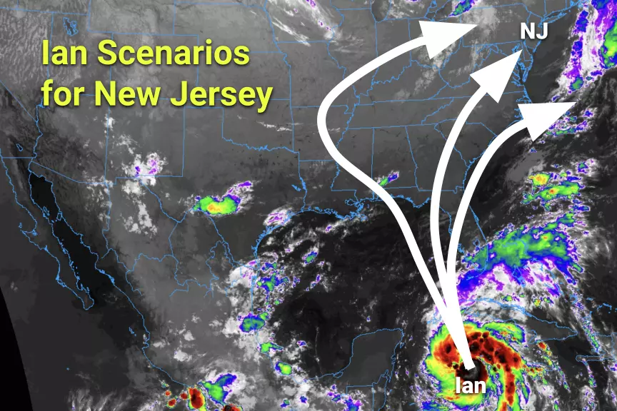
We can break down NJ's Ian forecast into three possible scenarios, which I am labeling Out to Sea, Direct Path, and Farther West.
Ian Scenario #1: Out to Sea
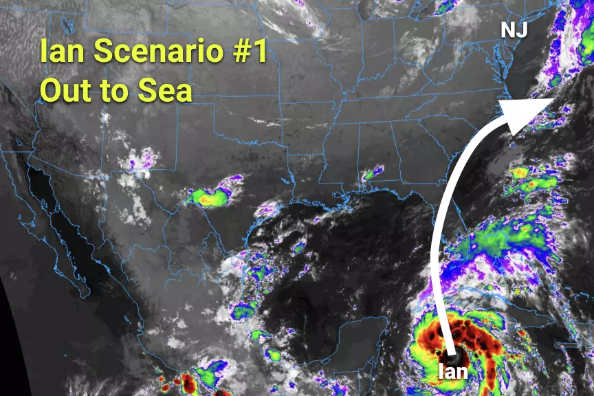
One of the newer tracks to emerge from our tropical forecast models is the idea of the storm making landfall around or just north of Tampa. Then charging through the Southeast U.S. and making a sharp right turn, ejecting into the Atlantic Ocean before reaching the Carolinas.
This is almost a "nothing at all" solution for New Jersey. We may feel some increasing cloud cover, wind, and/or humidity. And the surf would get rough as the storm eventually passes our latitude. But rainfall (and the threat of "dangerous" weather) here in New Jersey would be very limited.
Ian Scenario #2: Direct Path

Note: I'm not calling it a "direct hit". This track would involve a landfall just south of Tallahassee — right inside the "corner" of Florida's peninsula. The storm's momentum would continue to carry it to the north-northeast, directly toward New Jersey.
This would be a potentially rainy solution, for at least the southern half of the state. (It depends just how far inland Ian tracks.) It could also become a tornadic track, if the center of the storm maintains its energy and passes directly overhead.
More than likely, this brand of stormy impacts would be felt over the upcoming weekend, from about Saturday 10/1 to Sunday 10/2.
Ian Scenario #3: Farther West

The biggest danger New Jersey faces from tropical storms is water. Period, full stop. Many New Jerseyans are still very sensitive to that fact, after the catastrophic flooding impacts of Ida's remnants just over a year ago.
That's why a Panama City, Pensacola, Alabama, or Mississippi landfall would probably become a "worst-case scenario" for the Garden State. That track would shove the storm's remnants (and tropical moisture) far inland, possibly over the Great Plains. That would allow it to gather steam again before sweeping toward the East Coast. Heavy rain is the one and only concern with this kind of setup. Some models are pumping out 3 inches of total rainfall at the moment. Storm systems of tropical original make great drought busters. But — as we unfortunately experienced with Ida in September 2021 — a lot of rain in a short period of time can cause massive flooding issues.
This scenario would play out a bit later than the others too, likely in the Monday-Tuesday time frame.
The Ian Forecast: What Happens Next
As I've mentioned, the direction, speed, strength, and size of Ian as it makes landfall in Florida will directly dictate how and when the storm's remnants will affect New Jersey. There is still plenty of time and distance for all of those factors to "wiggle". And any little change could yield a huge difference in our ultimate forecast.
So we remain in a holding pattern at the moment. We will gather more information and insight over the next 48 to 72 hours. And then, if there are alarm bells to be rung, we will start talking more seriously by the end of the workweek.
Dan Zarrow is Chief Meteorologist for Townsquare Media New Jersey. Follow him on Facebook or Twitter for the latest forecast and realtime weather updates.
These First Names Will Title Each Hurricane This 2022 Season
Gallery Credit: Jimmy G
LOOK: The most expensive weather and climate disasters in recent decades
Gallery Credit: KATELYN LEBOFF
More From 94.3 The Point


