How the remnants of Zeta will impact NJ later this week
The Bottom Line
I decided to break from my usual "day by day" weather blog format, to focus on our big weather maker of the week: the remnants of Hurricane Zeta. Again, it will be remnants by the time it reaches New Jersey, a non-tropical storm system by the time it reaches New Jersey. Having said that, the variety of impacts will definitely be noticeable.

Before Zeta: Short-Range Forecast
Monday was even drearier and damper than I expected. And we still have some patchy fog and drizzle around New Jersey to start Tuesday morning. However, a weak cold front is passing from northwest to southeast across the state as I type this. This front is the leading edge of slightly cooler and especially drier air. Basically, it's going to sweep out the "junk".
I'm optimistic we'll see pops of sun by midday Tuesday. High temperatures will be close to seasonal normals, in the lower 60s (some 50s far north, some mid 60s far south). While it will turn into a decent fall day, another round of clouds and showers are expected Tuesday evening. Nothing heavy, just occasionally damp weather.
After those showers wrap up mid-morning Wednesday, we'll enjoy a mostly cloudy day with highs again in the lower 60s.
Our weather will go downhill as Zeta's remnants arrive Thursday morning.
About Zeta
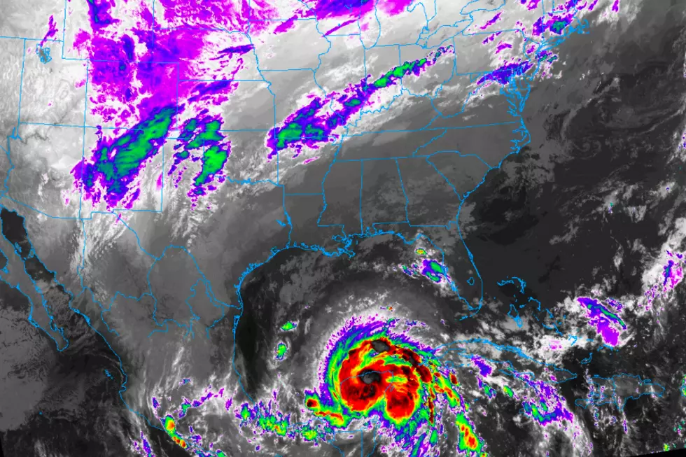
Zeta is the 6th letter of the Greek alphabet, and the 27th named storm of the 2020 Atlantic hurricane season. The storm is 1,500 miles southwest of New Jersey, after landfall upon the Yucatan Peninsula late Monday night as a hurricane. The topography there is relatively mountainous, weakening Zeta slightly to a tropical storm as of early Tuesday morning. As Zeta's center ejects into the Gulf of Mexico, it will re-intensify into a hurricane.
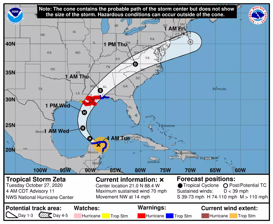
Zeta is forecast to make another landfall near the Louisiana-Mississippi coast Wednesday night. The remnant low will then track toward New Jersey, impacting us in the Thursday-Friday time frame.
In case you're keeping score, this is not the first storm system of tropical origin to impact the Garden State this year. Zeta will join Delta, Beta, Sally, Laura, Isaias, Fay, and Bertha. Quite the dysfunctional family there.
Soaking Rain
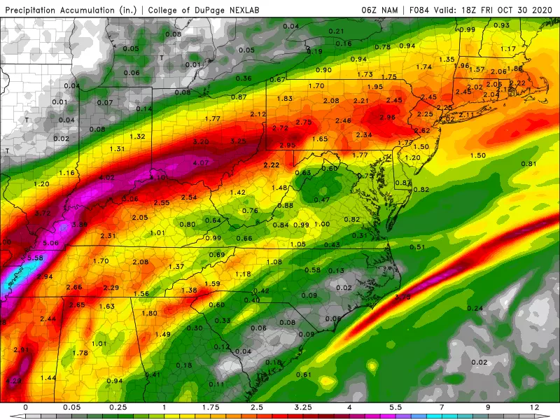
The biggest impact from Zeta will be an extended period of moderate to heavy rain. Forecast models are pretty much in lockstep regarding the timing. First raindrops arrive pre-dawn Thursday, becoming heavier and steadier around mid-morning. The heaviest rain is expected Thursday afternoon. While the rainfall will subside a bit Thursday night, the wet weather will be on top of New Jersey until (at least) Friday morning. That probably makes Thursday a total washout.
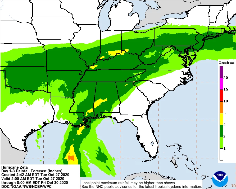
There is some variance among model rainfall totals, with solutions ranging between about 1 and 3 inches. In any case, it's going to be a widespread soaker.
As I like to say, the ground will be relatively "thirsty" — it will soak up slow, steady rain fairly well. The problem, however, will be the foliage. This time of year, fallen leaves can block storm drains and exacerbate any flash flooding issues. Leaves also become very slippery when wet, and can lead to increased vehicle spin-outs.
Wind
Not a huge deal, but definitely contributing to the "miserable-ness" of this impending inclement weather. I'm seeing top gusts out of the northeast at 20 to 30 mph. That puts us in the breezy to windy range.

Coastal Flooding
Because that wind is partially blowing from the northeast, and because the remnant low will track directly over the coast Friday morning, we are facing one or two rounds of high tide flooding.
Latest surge models show Thursday's afternoon high tide cycle will be OK. Then the concern grows, as 1 to 2 feet of storm surge causes minor to moderate flooding both Friday morning and Friday afternoon. That degree of water inundation will be similar to a moderate-strength nor'easter.
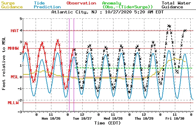
We'll have more detail and more insight on the flooding potential within the next day. For now, keep the threat in mind and prepare to not park your car in a vulnerable spot on Friday.
Big Cooldown
On the backside of Zeta, a strong north-northwest wind will drag a pool of downright cold air over New Jersey. Easily the coldest of the season so far.
Thursday will start with thermometers around 60 degrees — that will be the high temperature for the day. By Friday morning, they'll be knocked back to about 50.
And Saturday morning low temperatures will range from the upper 20s in NW NJ to about 40 degrees along the southern coast. Brrr! I expect most of the state (away from coastal and urban areas) to experience the first frost of the season. And areas well inland (i.e. "north and west") could fall below the freezing mark.
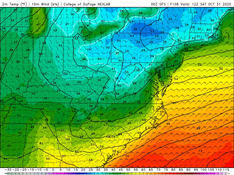
Of course, Saturday is Halloween. And the day will be bright and calm, but chilly. High temperatures will only reach around 50 degrees — so plan for an extra layer or two under your costume.
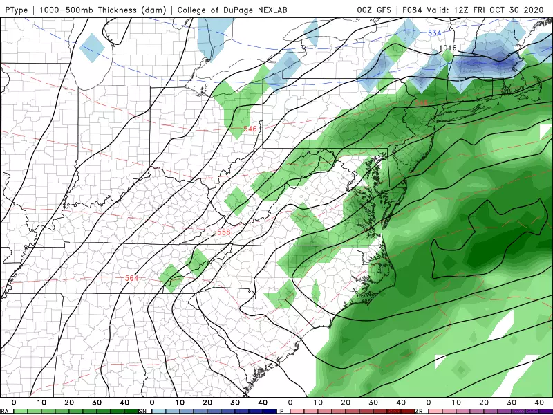
The "S" Word
So the two biggest impacts from Zeta's remnants are rain and cold. But what if the temperatures plummet enough before the precipitation ends? Snow.
Models have gone back and forth about just how south any frozen precipitation will reach — and the timing of the cooldown and precipitation has a lot to down with that. We're really just talking about some wet snowflakes mixing with rain throughout the northern third of New Jersey (above I-78). No accumulation or travel impacts are expected.
After Zeta: Long-Range Forecast
The weekend will be cool and generally pleasant, with highs near 50 on Saturday (Halloween), 60 on Sunday. One more cold front Sunday evening will drive through a round of rain showers, followed by another shot of cooler air. Next week looks pretty dormant, with temperatures mainly holding below normal in the 50s.
Dan Zarrow is Chief Meteorologist for Townsquare Media New Jersey. Follow him on Facebook or Twitter for the latest forecast and realtime weather updates.
The 10 Best Sunrises in Seaside Park
More From 94.3 The Point