NJ Memorial Day Weekend forecast: Unsettled start, nice finish
The Memorial Day Weekend is upon us, arriving with lighter-than-usual fanfare given the current state of the world. Still, I suspect backyards and beaches and boardwalks will be busy over the holiday weekend. Unfortunately, the weather will provide an unsettled start to things, with showers and clouds and rough surf. But the forecast for the end of the weekend into next week improves dramatically.
We're starting this Friday morning, with temperatures around the 50-degree mark — notably warmer than Thursday morning, by about 10 degrees. High temperatures Friday afternoon will be highly dependent on how thick the clouds get and how much rain we see, ranging from the mid 60s to lower 70s. (It is totally possible that northern New Jersey will be warmer than southern New Jersey.)
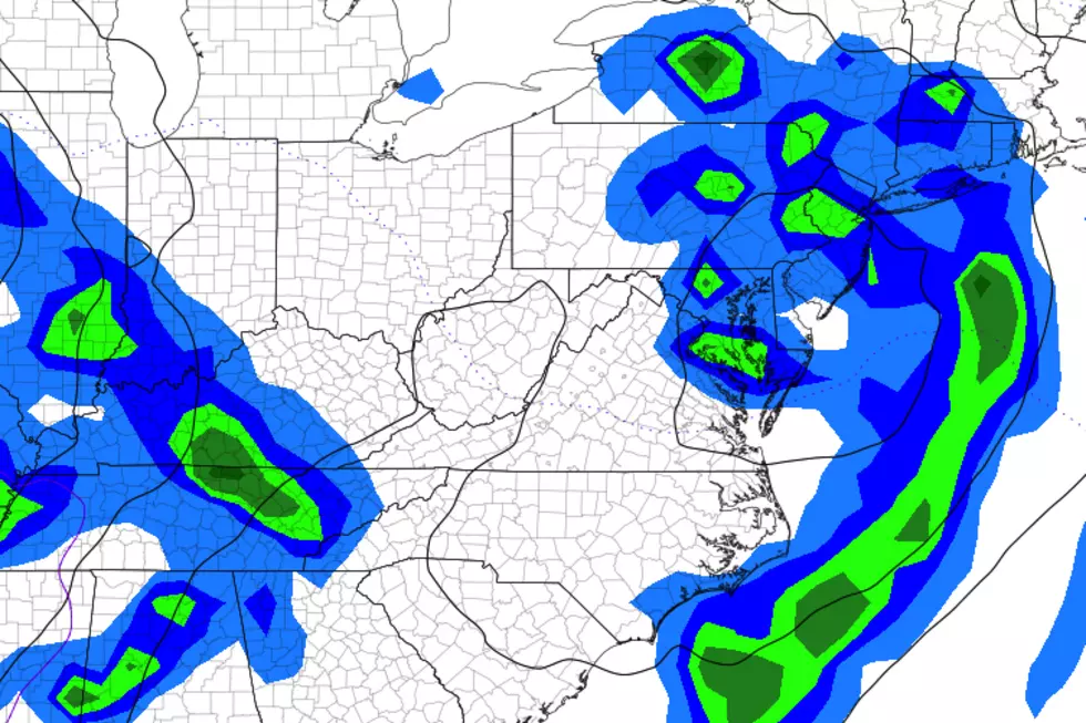
We have been watching a storm system crawl through the southern U.S. all week long, dumping torrential rain along the way. It has finally started moving in our direction. As of this writing (5 a.m.), the leading edge of rain is over Maryland and Delaware. Skies will rapidly become mostly cloudy through the morning. Showers could bubble up into SW NJ as early as 8 a.m. Friday, potentially reaching NE NJ by around 4 p.m. So, for most of the state, the best chance for scattered raindrops Friday will come from around midday through the afternoon.
In addition, a high risk of rip currents and rough surf is posted once again for the Jersey Shore. Even though Tropical Storm Arthur is but a distant memory at this point, 4 foot waves are still possible. Seas will continue to calm through the weekend.
The chance for spotty showers will continue Friday night. It's going to feel mild and pretty humid overnight, as thermometers only dip to around 60 degrees. That kind of nighttime temperature would be typical in mid-June or early September.
Saturday looks pretty unsettled, as the center of that low pressure (storm system) passes directly over New Jersey. I still maintain it won't be a washout though. Scattered pockets of rain are likely from morning through evening, with rumbles of thunder possible along the way. Saturday's high temperatures will be similar to Friday's, in the mid 60s to lower 70s. (Note: Models have suggested that IF the rain tapers off soon enough and IF the sun peeks out for an hour or two, SW NJ could pop into the mid 70s.)
As the rain tapers off late Saturday, the wind will kick up a bit — potentially gusting to about 30 mph through Saturday evening. That wind, on the backside of our storm system, will kickoff a drying trend through the second half of the holiday weekend.
So Sunday will be drier and slightly cooler, with morning lows near 50 and afternoon highs in the mid 60s (at best). Still lots of clouds around, but you should get pleasant pops of sun too.
Memorial Day Monday is the shining star of this weekend's forecast. Partly sunny skies and highs bumping into the seasonable lower 70s — nice! (It will be cooler along the Jersey Shore, likely in the 60s.)
And most of next week looks dry and reasonably pleasant too — as long as you like it hot. As I've been promising, as soon as we get rid of the on-shore breeze, temperatures will skyrocket. Latest guidance suggests 80s return away from the coast on Tuesday. Could we push close to 90 degrees by Wednesday and Thursday?
Despite the clouds and the rain and the state of the world, I truly hope you have a refreshing and reflective Memorial Day Weekend. Be safe and stay healthy, my friends. The weather blog will return after the holiday, on Tuesday 5/26.
Dan Zarrow is Chief Meteorologist for Townsquare Media New Jersey. Follow him on Facebook or Twitter for the latest forecast and realtime weather updates.
More From 94.3 The Point


