
NJ weather: September will end quiet and cool, still watching Ian
The Bottom Line
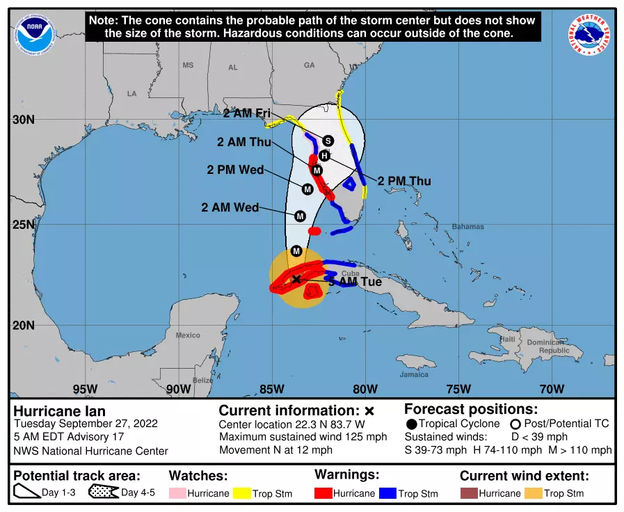
All eyes in the meteorological world are on Hurricane Ian, which made landfall along Cuba's southwest coast as a category 3 major hurricane early Tuesday morning. Florida is next. And then New Jersey could start to feel impacts from the storm as early as the weekend. But exactly what we'll see and when is still very much up in the air.
Meanwhile, the theme of the forecast through the final few days of September? Slightly below-normal temperatures. Alongside generally quiet weather conditions.
Tuesday
Monday's weather was fabulous. (With the exception of spotty afternoon showers, I suppose.) I wish we could "copy and paste" that weather over again a few more times.
Mother Nature will almost do just that for Tuesday. We will once again see lots of sunshine, with some fair-weather clouds around both early and late. It will be breezy at times, with gusts to about 20 mph. And temperatures will end up a couple degrees cooler than it has been: mainly 50s in the morning, lower 70s for highs in the afternoon.
I can't completely rule out a sprinkle at some point. Especially to the northwest, as a weak cold front crosses the area Tuesday evening. But I would not bet on it.
Tuesday night, we may descend into "jacket weather" again. Low temperatures will bottom out on either side of 50 degrees, under mainly clear skies.
Wednesday
Both our air and our weather will be dry on Wednesday. (Although there will be a batch of rain traveling just north of NJ.) I'll call skies partly sunny. And the slow cooldown continues, as highs only reach the upper 60s to around 70. Now we're talking about 5 degrees below normal, feeling more like October than September.
Thursday
Still dry. But clouds will continue to build, and temperatures get slightly cooler temperatures once again. My forecast puts highs squarely in the upper 60s.
Friday
On Friday, we may start to fall until the thumb of Hurricane Ian's outermost bands and tropical moisture. (For more on Ian, keep reading.) At least one model solution shows a block of thick clouds and even a band of precursor showers creeping into southern New Jersey on Friday.
I'll be honest — a Friday arrival seems early, given what we know about Ian's forecast track at this point. But still, the chance is there, so it is worth mentioning.
Even with possible clouds and showers, high temperatures on Friday will hold steady from the days before, around the upper 60s.
The Extended Forecast: Ian
As storm recovery begins in Cuba and storm preparations accelerate along Florida's, we are still monitoring the chance of potential Ian impacts here in New Jersey within the next week.

In Monday's weather blog entry, I laid out three potential track scenarios for Hurricane Ian. 1.) Cutting across the southeastern U.S. and heading out to sea, 2.) Skirting up the Appalachians toward NJ, and 3.) a path farther west that would allow the storm to gather steam before shoving east again.
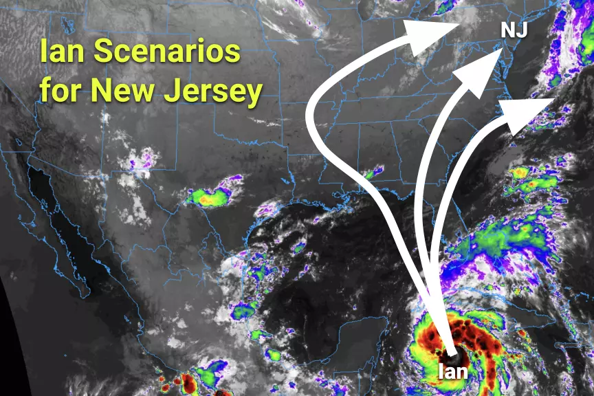
At this moment, I think the middle outcome (#2) is most likely. That is a potentially rainy outcome for New Jersey. (Especially to the south.)
I want to stress again that the storm is still far away, over a thousand miles south-southwest of Cape May, N.J. That leaves plenty of time and distance for things to "wiggle". But let me take a stab at some of the most pressing forecast questions. We will update these answers with more confident information as time goes on.
—When? Ian's impacts (showers and clouds) may creep into New Jersey as early as Friday or Saturday. Even more likely on Sunday. And "prime time" would potentially be Monday into Tuesday, with a period of nasty, rainy, windy weather.
—Who? Latest model consensus shows New Jersey's biggest storm impacts would be felt in the southern half of the state. That's where the most prolonged and potentially heavy rainfall would fall. The current consensus forecast puts little to no rain over northern NJ.
—Rainfall? The biggest question mark at this time. But potentially Ian's biggest impact on NJ. I have seen model forecasts that suggest only a few raindrops, limited to the southern tip of the state. I have seen 3+ inch rainfall predictions. And the latest Euro model happens to pump out 6+ inches of rain for South Jersey. That is a wide range of possibilities, with a wide range of potential impacts. For now, just know that flooding is absolutely on the table. As we saw with Ida last September (and many other tropical storms before that), never underestimate the rainfall potential of tropical moisture.
—Severe? If the center of Ian's remnant low passes over New Jersey, there would be a risk of twisting thunderstorms, yielding tornadoes. Not our primary concern, but worth mentioning.
—Wind? Ian will not be a hurricane or tropical storm when it reaches New Jersey's latitude. I do not think there's any scenario that pushes destructive winds through the state. But it could certainly get windy and nasty for a time, with possible gusts over 30 mph.
—Surf? Since the storm will be attacking us from the southwest — the inland side — storm surge and coastal flooding will not be an immediate concern. There could be some surge and swell on the backside though, as it shoots out to sea.
Lots to watch and lots to think about. I realize this forecast is still rather generic and vague. Unfortunately, that is the truth of tropical weather forecasting. It is a delicate, slow process. Once Ian reenters the Gulf of Mexico and approaches Florida — within the next 24 to 48 hours — we should start piecing together a much clearer picture of what's ahead for the great Garden State.
Dan Zarrow is Chief Meteorologist for Townsquare Media New Jersey. Follow him on Facebook or Twitter for the latest forecast and realtime weather updates.
NJ school holidays with the biggest buzz
Gallery Credit: Erin Vogt
Every major Spirit Halloween location in New Jersey for 2024
Gallery Credit: Mike Brant
More From 94.3 The Point


