Winter’s final blow: Rain, wind, cold, snow, flooding for NJ Thu-Fri
The Bottom Line
Remember exactly one week ago? Sunshine and record warmth. Widespread 70s across New Jersey? Ahhh, what a tease.
We do have sunny, dry, pleasant, warmer weather on the way this weekend, as we spring into Spring. But first, a powerful storm system will combine with yet another cold air mass to bring a multitude of weather impacts to New Jersey in winter's final days. (By the way, this is the same system that sparked a significant tornado outbreak in Mississippi and Alabama on Wednesday.)
The headline of this post lists New Jersey's primary impacts in time order: Rain, wind, cold, snow, and (coastal) flooding.
What are my biggest concerns, looking at the next 36 to 48 hours as a whole?1.) Heavy rain Thursday, with embedded thunderstorms, will make for sloppy conditions.2.) Fierce winds will blow around garbage cans and make for bitter wind chills Thursday night.3.) And last but not least, a quick burst of snow and wintry mix could make for treacherous travel during Friday morning's commute.
Let's dive into the details, so you can plan your day(s) and stay safe. And let's all look forward to the arrival of Spring at 5:37 a.m. on Saturday, with a warmup to follow shortly thereafter!
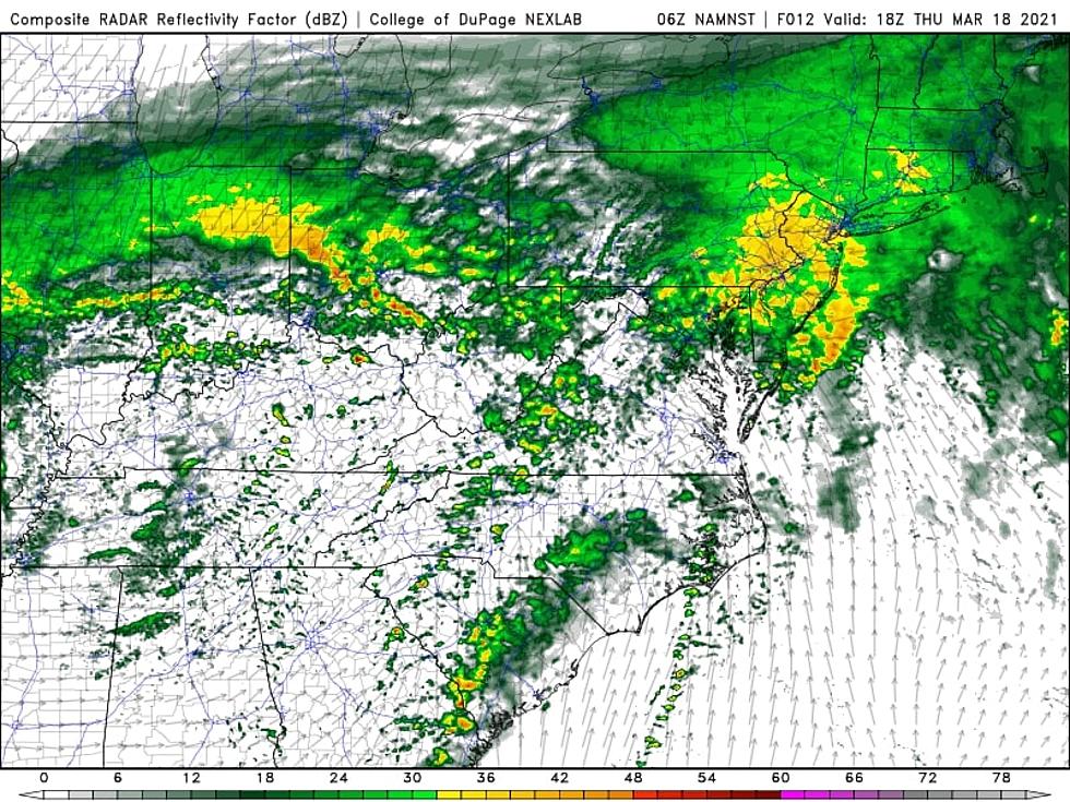
Rain: Thursday Almost a Washout
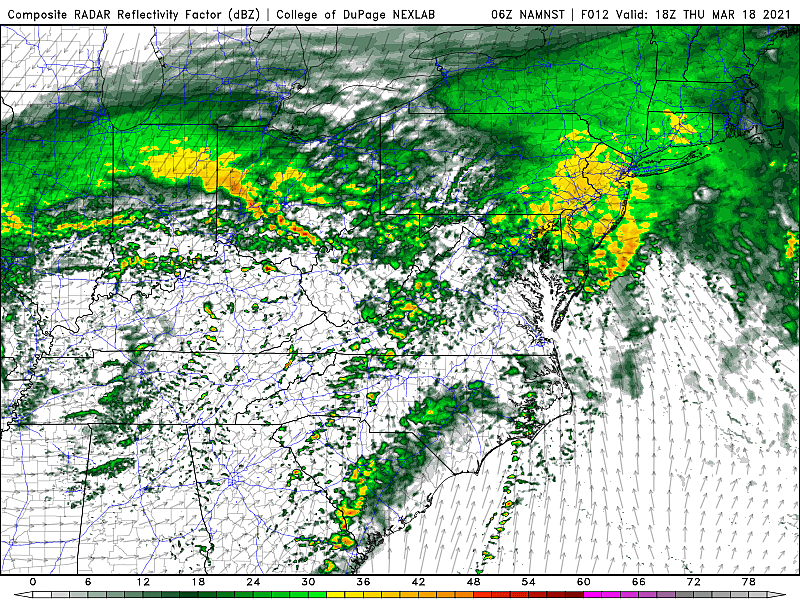
—Start... First raindrops will spread from southwest to northeast between about 6 a.m. and 11 a.m. Thursday morning.
—Peak... Downpours and embedded thunderstorms are expected Thursday afternoon.
—Tapering... Thursday evening (around 5 p.m.) should bring pockets of dry air, especially in South Jersey. However, expect wet conditions to continue through Thursday night and Friday morning.
—Totals... 0.75" (South) to 2+"
—Impacts... The ground is thirsty after a 2-week dry stretch, so widespread flash flooding is unlikely. Be vigilant for low visibility and big puddles, especially during the heaviest rain Thursday afternoon.
Wind: 40 mph Gusts Thursday Night
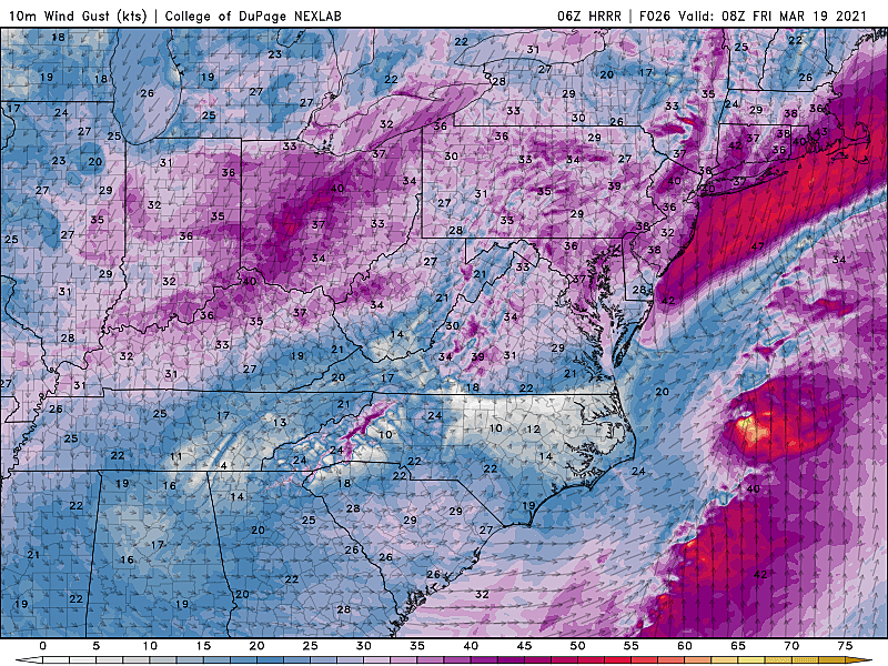
—Timing... The strong north wind will kick up around Midnight, with peak gusts through about 8 a.m. Friday morning.
—Top Gusts... 40+ mph.
—Impacts... Garbage cans and light lawn furniture will blow around. Driving may be difficult, especially in high-profile vehicles (vans, trucks, etc.) Wind-driven rain will further reduce visibility. And the wind will carry in cold air, causing bitter wind chills by Friday morning.
Cold: Bitter Wind Chills Friday
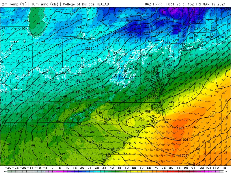
—Temperatures Start to Drop... Our temperature trend will generally be "diurnal" on Thursday - in other words, thermometers will start to go down after sunset Thursday evening.
—Below Freezing... For most of the state (away from the southern coast), thermometers will dip below 32 degrees between 2 a.m. and 7 a.m. (Keep reading for details about the potential for wintry weather.)
—Friday AM Low Temperature... 27 (North) to 34 (South)—Friday AM Wind Chill... 5 (North) to 20 (South)
—Friday PM High Temperature... 37 (North) to 42 (South)
Snow: Quick Burst Friday Morning

—Note... While a changeover to snow is not guaranteed, most models show at least a brief period of wintry mix at the tail-end of this storm system. Especially to the north, although there is a chance of snowflakes across all corners of the state. You'll notice I'm not calling this a "winter storm" - the potential for snow and sleet and freezing rain is not the primary impact from this system.
—Changeover Time... 1 a.m. (NW) to 8 a.m. (SE)
—End Time... A couple of hours after it begins. Precipitation should end completely in NJ by about 10 a.m. Friday.
—Accumulations... While over an inch of snow may fall from the sky, it's going to have a very hard time sticking to the wet, relatively warm ground. So little to no accumulation is expected. Maybe a coating of slush.
—Impacts... The timing of the potential snow is what concerns me the most, coinciding with Friday morning's commute. I highly doubt school delays or closings will be necessary, although occasional low visibility and slushiness could become issues for drivers.
Coastal Flooding: One or Two Rounds of Minor Flood
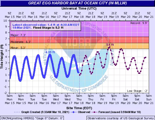
—When... Both Friday morning's and (especially) Friday evening's high tide cycles will run slightly normal than usual due to the storm.
—How Much... Tidal models at some (not all) gauges are suggesting a brief spike above Minor flood stage. Probably measuring the water rise in inches, rather than feet.
—So What... That's enough surge to cause water issues for vulnerable coastal areas. The "usual spots," if you will. (Barrier islands, I'm looking at you.)
Looking Ahead
After about 24 hours of yuck, we're looking at a very nice forecast for the first weekend of Spring. (The Vernal Equinox occurs at 5:37 a.m. Saturday morning.)
After the storm, despite partial clearing, Friday will stay cold and blustery. High temperatures will struggle to reach 40 degrees. With a continuing wind chill, of course.
Bright sunshine will take over Saturday, as seasonable temperatures return too. Highs will pop into the 50 to 55 degree range - precisely normal for mid-March. The only exception will be the Jersey Shore. With a southeasterly (on-shore) breeze for the foreseeable future, the immediate coast will end up cooler (in the 40s) each day.
Sunday and Monday look even better, as inland thermometers climb into the 55 to 60 degree range. Again, we'll enjoy splendid sunshine and dry conditions.
On Tuesday, more temperatures could hit the 60-degree mark. Sunshine will win the sky for the first part of the day, with late-day clouds.
Our next chance of rain? A chance of showers on Wednesday.
Please be smart and stay safe during and after this nasty storm. We'll be with you on-air and online for the duration.
Dan Zarrow is Chief Meteorologist for Townsquare Media New Jersey. Follow him on Facebook or Twitter for the latest forecast and realtime weather updates.
Strange NJ Laws You've Never Heard Of
More From 94.3 The Point