70 degrees! Thursday will probably be NJ’s warmest day of the year so far
The Bottom Line
For most of New Jersey, the warmest day of the year so far occurred earlier this week. (A few spots hit 70 degrees on Tuesday.) All signs point to thermometers besting that mark on Thursday (for all but the Jersey Shore), as our warm, springlike weather pattern continues.
Friday will be warm too, but less perfect with spotty rain showers around. And then a burst of cold wind will pave the way for colder temperatures for the final full weekend of winter.
Thursday
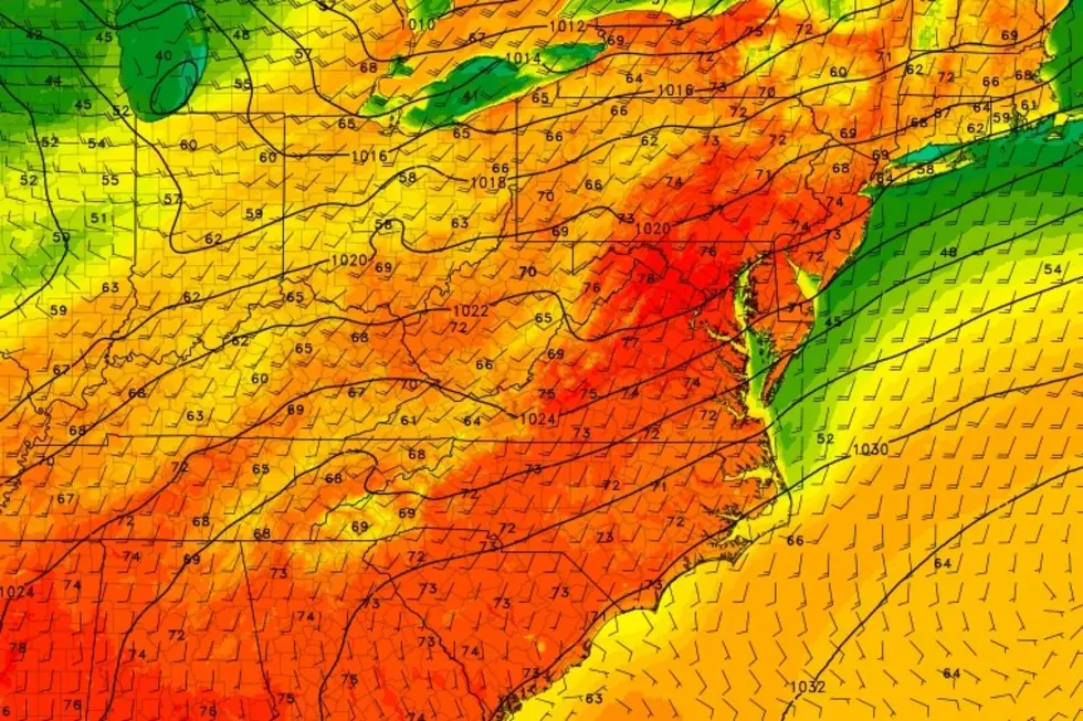
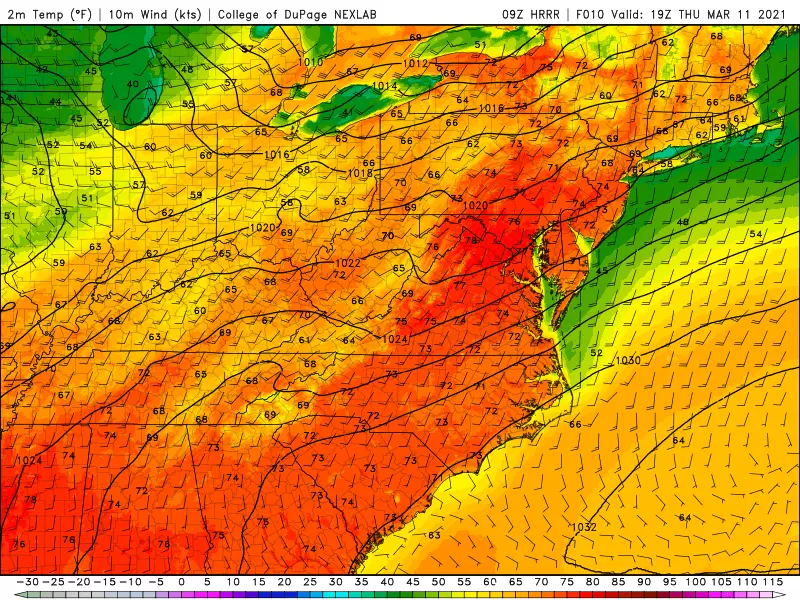
We will come close to record high temperatures on Thursday. But I think we'll come up just shy. Records: 71 at Newark (1977), 72 at Trenton (1977), 79 at Atlantic City (1967). My latest forecast: 67 at Newark, 70 at Trenton, 71 at Atlantic City.
Even so, we're running an astounding 20 degrees above seasonal normals right now!
You may have to battle patches of dense fog early on this Thursday morning. (My ride to work was especially dark and harrowing.) Visibility has been as low as a quarter-mile. Fog should start to mix out after sunrise. And I expect it to be completely done by around 9 a.m.
Skies won't be as brilliantly sunny as the past two days, with some clouds in the mix. Highs will reach the lower 70s across inland central and southern New Jersey. Upper 60s to the north. And at the Jersey Shore, a sea breeze will probably kick in by the afternoon. That will limit temperatures to the 50s along the immediate coast. A big difference from the inland blast furnace, but certainly better than Wednesday's chilly 40s.
Temperatures will actually stay on the mild side Thursday night, only falling into the lower 50s. A few model solutions put a shower or sprinkle over North Jersey Thursday evening - it's enough of a chance to warrant a mention in the forecast.
Friday
One more warm day, but not a perfect forecast.
A batch of spotty rain showers will drive through the state Friday morning, sweeping from northwest to southeast between about 4 a.m. and Noon. Just a brief period of light rain.
We should see breaks of sun into Friday afternoon, especially the farther north in the state you go. High temperatures will push into the mid 60s, on average. Sea breeze may or may not become an issue again. (Depends how much sunshine we see along the coast - that's what causes the sea breeze machine to turn on.)
Although it has felt like Spring this week, it's not actually Spring yet. So you knew a cooldown was coming eventually.
Our inevitable cold front will arrive Friday evening. It looks mainly dry, although I wouldn't rule out an isolated (snow) shower through early Saturday morning. A brief period of cold gusty wind is likely overnight, perhaps over 30 mph. And, of course, temperatures will nosedive.
Although not all model guidance agrees, I suspect the vast majority of NJ (all but the southern coast) will drop below the freezing mark Saturday morning.
Saturday
Chilly, jacket weather returns. The wind should lighten up quickly, and it turn into a sunny and dry day. But high temperatures will be stuck in the mid 40s. Back to below normal.
Sunday
Mostly sunny, breezy, and seasonable. Highs will pop back to around 50 degrees, give or take. Not bad - just a far cry from the week's wonderful warmth.
The Extended Forecast
I've been endlessly stressing that winter isn't over yet. And that our weather pattern looks more active starting around the midpoint of March.
Well, here we go again. A storm system is forecast to pass south of New Jersey from Monday night into Tuesday. The current consensus track shows precipitation clipping the southern half of the state. And given the timing, and the fact we're on the northern (colder) side of the storm, that precipitation may take the form of snow or wintry mix. Light accumulations are possible.
With almost 5 days to go until first flakes, that's about all I have to say about the storm potential right now. Once we're a bit closer - let's say Saturday - we'll dig into the timing, impacts, and potential totals picture much more closely.
Dan Zarrow is Chief Meteorologist for Townsquare Media New Jersey. Follow him on Facebook or Twitter for the latest forecast and realtime weather updates.
Have You Seen Them? Monmouth County's Most Wanted
More From 94.3 The Point