How Hurricane Isaias might affect NJ: Scenarios, impacts, timeline
I can't believe that, for the second time in less than a month, we are talking about a tropical cyclone that could bring some nasty sky and surf conditions to New Jersey. (The first, of course, was Tropical Storm Fay on July 10.)
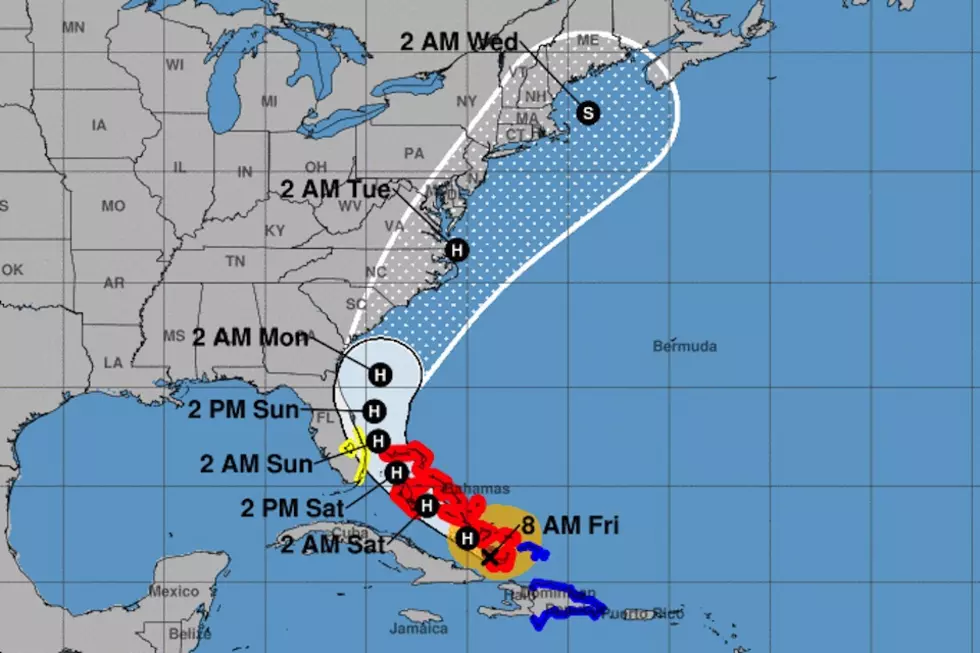
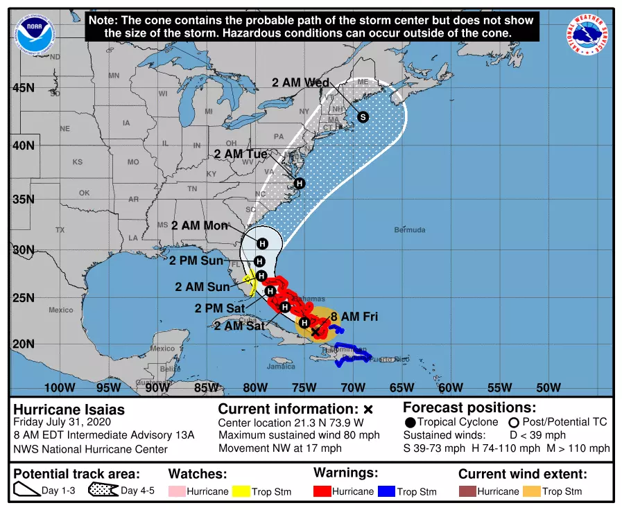
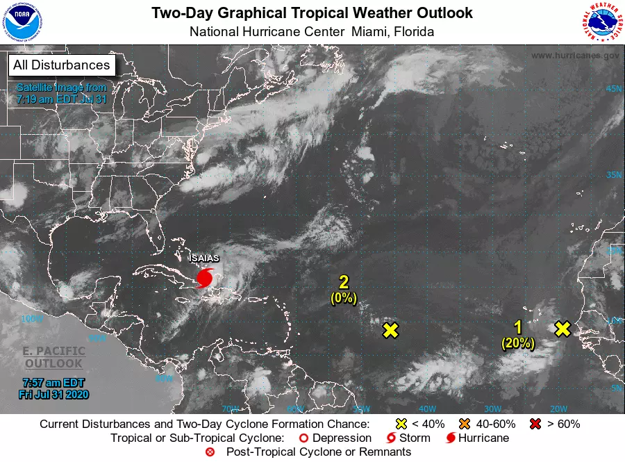
Hurricane Isaias (pronouned ees-ah-EE-ahs) was upgraded to a category 1 hurricane overnight, following an investigation by the Hurricane Hunters aircraft. As of 8 a.m., maximum sustained winds were holding at 80 mph. The storm is centered about 1,220 miles south of Cape May, N.J. and will drive heavy rain and wind through the Turks & Caicos Islands and the southern Bahamas on Friday.
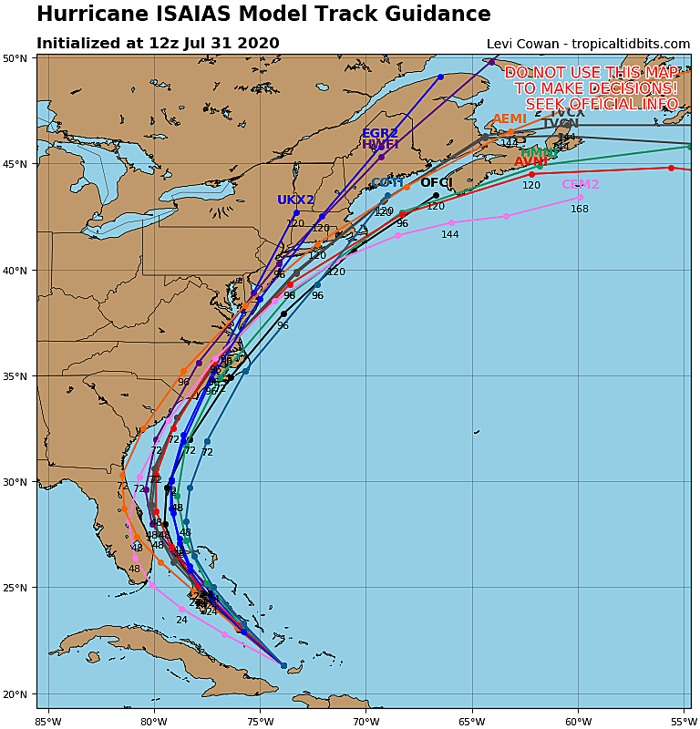
As the National Hurricane Center forecast above shows, New Jersey is firmly on the western edge of the 5-day forecast "cone of uncertainty". That shaded area represents a two-thirds (67%) probability of the location of the center of the storm plotted every 12 hours.
The purpose of this special weather blog post is to discuss both what we know and what we don't know about Isaias's trajectory and potential impacts. I'm going to highlight some of the forecasting challenges and benchmarks here, followed by three possible storm scenarios. I'll be focusing on the four primary weather and surf concerns from tropical storms and hurricanes: Heavy rain, damaging wind, storm surge (coastal flooding), and rough surf (erosion).
Fair warning: There are a lot of "possible"s and "could be"s here — if you're looking for more specific, confident details, you'll have to wait another day or two. That's just how the science of meteorology and tropical forecasting works.
Forecast Facts
1.) It is becoming increasing likely that Isaias will significantly impact the U.S. East Coast in the coming days.
2.) However, forecast models have done an incredibly poor job with this storm so far, especially with regard to intensity and speed.
3.) Model guidance shows an abnormally wide spread in the timing of the storm impacts arriving in New Jersey.
4.) Therefore, even though we are zeroing in on a consensus forecast storm track, uncertainty remains pretty high.
5.) We usually get more solid resolution on a tropical system's rain, wind, surge, and surf forecast about 72 hours (3 days) out.
Timeline
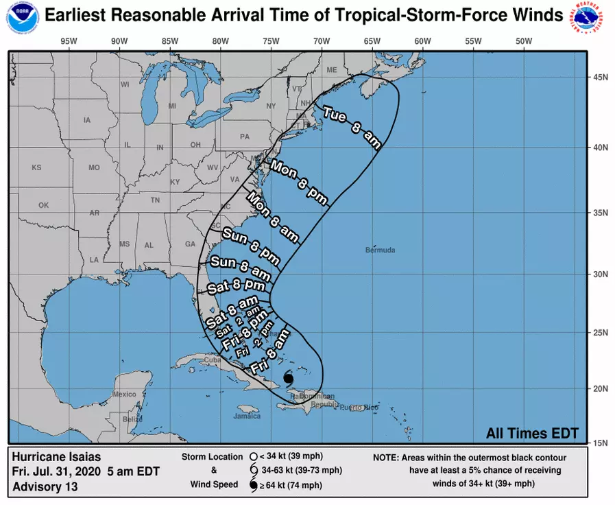
The first impact of the hurricane we're going to feel here in New Jersey will be a churned up Atlantic Ocean. Throughout the weekend, the risk of dangerous rip currents along the Jersey Shore will be elevated. And especially late Sunday, I suspect the ocean will start to get pretty rough.
Timing for everything else is unfortunately still fuzzy. The heaviest rain will be found along the "front half" of the storm, which may starting pushing into the Garden State as early as Monday evening (after 5 p.m.). Impacts may linger as late as Wednesday morning.
Middle of the Road / Most Likely Scenario
My favored forecast track at the moment has the center of Isaias passing about 100 to 200 miles east of the Jersey Shore sometime on Tuesday, as a strong tropical storm or weak category 1 hurricane. That is reasonably close to the GFS model forecast, which suggests the following weather and ocean impacts:
—Rain... Totals ranging from about a quarter-inch in NW NJ to about 3+ inches closer to the coast.
—Wind... Top gusts between 40 and 60 mph at the Jersey Shore. More like 20 to 30+ mph inland.
—Surf... 6+ foot ocean waves, causing minor to moderate erosion.
Best Case Scenario
If high pressure over the central Atlantic shifts or weakens, Isaias's storm track will "wiggle" to the east (the out-to-sea direction). Many members of the GFS Ensemble suite are showing a track along this vein. If such a solution plays out, here are the approximate minimum impacts for NJ.
—Rain... Little to no rain along the Delaware River in western New Jersey, maybe over an inch of rain along the oceanfront
—Wind... Top gust at the Shore only about 25 mph.
—Surf... 6+ foot ocean waves, causing minor to moderate erosion.
Worst Case Scenario
Following closely with this morning's runs of the Euro and Euro ensembles, the upward bound for Isaias is honestly a little scary: I hesitate to post such (overly?) dramatic numbers — but I want you to understand why there is real concern about this storm. This scenario would be highly dependent on both the track of Isaias's center and the orientation of the heaviest rain bands and fiercest wind.
—Rain... 6+ inches, with the highest totals along the southern coast.
—Wind... I mean, if this thing maintains it's strength and the track is perfect, a period of hurricane force winds can't be ruled out. Sustained 60+, gusts to 100?
—Surf... 12 foot ocean waves crashing at the beaches, causing moderate to severe erosion.
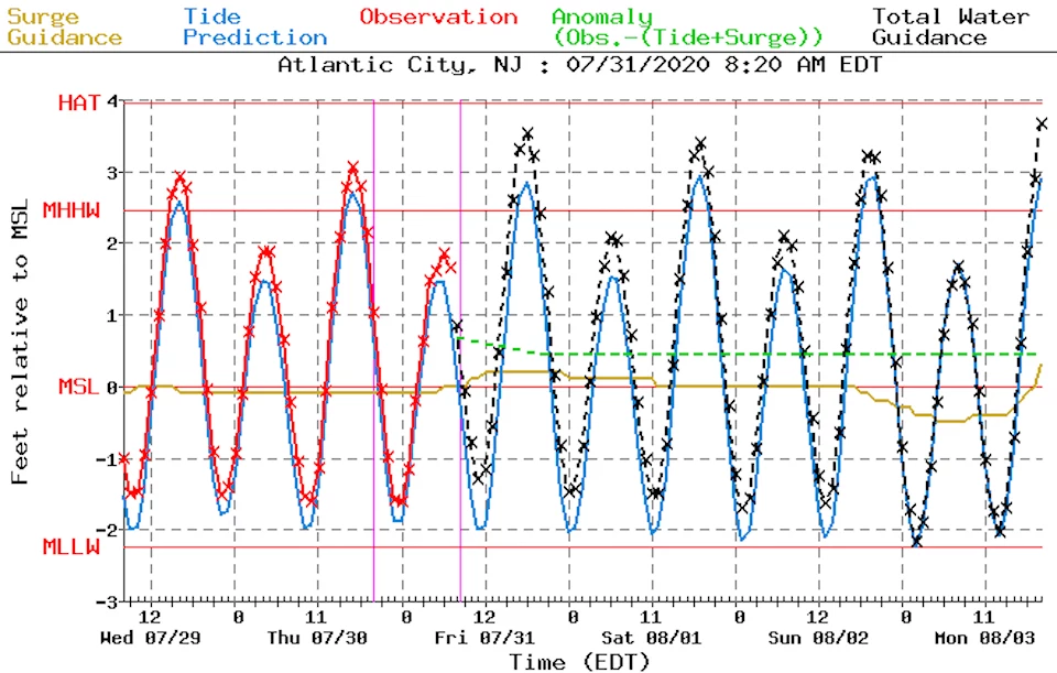
A Note on Storm Surge
You'll notice I omitted once storm impact from my scenarios above. And that is storm surge, the primary driver of coastal flooding along the Jersey Shore. We just don't have model guidance on surge (in feet) or tidal flooding magnitude (in categories) until about 72 hours beforehand. So I don't feel comfortable making a blind guess at how the numbers may play out.
I will say that some degree of coastal flooding is likely. And I will point out that we have a Full Moon coming up on Monday 8/3. Other than that, I'm going to withhold an opinion on potential surge until my next forecast update.
Warning Signs a.k.a. When to Really Worry
My heart sank as I reviewed the data this morning, and saw the potential for Isaiac to go beyond "inclement" here in New Jersey. As I've mentioned over and over, there's still the need a lot of "wiggle room" built into this forecast — that's why I've opted to lay out the three scenarios above. You do not need to go overboard in planning, preparing, and/or panicking over the storm just yet.
But here are three events that would make me more concerned:
1.) If Isaias intensifies further at any point. (Very few major models are suggesting it will become a category 2+ storm.)
2.) A landfall (or near-landfall) of the eye on the east coast of Florida on Sunday. (Suggesting a more westerly track.)
3.) Tropical storm or hurricane watches are issued along the Jersey Shore about 48 hours prior to arrival. (I feel like this is almost a certainty at this point.)
What Comes Next?
Enjoy Friday's rain and cooler temperatures. And have a great weekend. Keep an eye on the forecast. And be extra careful if you'll be jumping in the ocean.
Unless the forecast swings dramatically, I'm committed to at least once-daily weather blogs through the weekend. (Next one coming sometime Saturday morning.) And then starting Monday, I suspect I'll be on the weather desk around the clock until the storm threat is over. Our news, traffic, programming, and digital teams are ready to go too.
By the way, there are two more tropical waves charging across the Atlantic behind Isaias. This already record-breaking Atlantic hurricane season is just starting to heat up.
More From 94.3 The Point